General Geology of Barnstable County, Massachusetts
(Reprinted from the Soil Survey of Barnstable County, Massachusetts,
Fletcher, 1993)
Recommended Books: Roadside Geology of Massachusetts (James William Skehan)
Cape Cod and the Islands: The Geologic Story (Bob Oldale)
Recommended Links: Geologic History of Cape Cod Massachusetts
Glossary of
Landform and Geologic Terms (NSH)
Robert N. Oldale, geologist, U.S. Geological Survey, helped prepare this section.
The landscape of Barnstable County owes its origin to the last continental glacier and to the rise in sea level that followed glaciation. The moving ice scraped, ground, and picked up the bedrock of southern New England and deposited it as the glacial and postglacial sediments of Cape Cod. The rock debris, called drift, was carried south by the ice and deposited along the ice front. The result was the glacial landforms of Cape Cod. Later, as the sea drowned the glacial cape, the drift along the shoreline was eroded and re-deposited as beaches and spits. Windblown sand was deposited as dunes.
The exact age of the glacial deposits is not known. The deposits do not date back to more than 18,000 to 20,000 years ago, when the continental glacier reached its maximum advance and extended as far southward as Nantucket and Martha's Vineyard (7). They are older than the glacial deposits near Boston, which, according to radiocarbon dating, are about 14,000 years old (4).
The glacier in southeastern Massachusetts was formed into lobes by basins in the underlying bedrock (13). The lobes occupied the present sites of Buzzard's Bay, Cape Cod Bay, and the Great South Channel to the east of Cape Cod. Generally, the two western lobes contributed drift to the inner part of Cape Cod and the South Channel lobe contributed drift to the outer part. Retreat of the lobes was sequential from west to east. Generally, the oldest deposits were laid down by the Buzzard's Bay lobe and the youngest deposits were laid down by the South Channel lobe (9).
A generalized geologic map of Barnstable County was compiled from detailed 7.5-minute geologic maps made by the U.S. Geological Survey at a scale of 1:31,680 or 1:24,000 (8, 11). The map shows the distribution of geologic units (fig. 3).
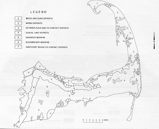
Figure 3. Geologic Map of Barnstable County.
Click Here for a Soil Parent Material (Surficial
Geology) Map.
Rock debris carried southward by the continental glacier was deposited along the ice front. In areas where the debris was laid down directly by the ice, deposits are unsorted and unstratified. Unstratified drift, or till, is made up of rock material of all sizes, ranging from boulders tens of feet in size to tiny particles of clay. Till is commonly associated with moraines and areas of knob and kettle topography.
In most places the debris was sorted by meltwater streams and deposited as stratified drift. In the ice-contact zone the depositional environment was chaotic. It was characterized by rapid changes in stream volume and stream course. In this zone the stratified drift is coarsest, mostly gravel and sand, and includes till and boulders deposited by the ice. Away from the ice-contact zone, the stratified drift becomes increasingly more sorted and finer grained. These outwash deposits are mostly sand and gravelly sand. On Cape Cod most of the meltwater streams flowed into pre-glacial lakes where very fine sand, silt, and clay were deposited (9).
Glacial deposits make up the distinctive landforms that are the basis for geologic mapping on Cape Cod. The most prominent landforms are the Buzzard's Bay and Sandwich Moraines. These landforms were formed by re-advances of the Buzzard's Bay and Cape Cod Bay lobes against ice-contact margins of the Mashpee Pitted Plain and the Barnstable Outwash Plain. Advancing ice displaced the deposits underlying the outwash plains by thrusting and folding (10). The moraine surface is characterized by ridges, knobs, and kettles and by ridges that run approximately parallel to the trend of the moraine.
Outwash plains are the most common glacial landform. On the inner part of Cape Cod, the outwash plains slope southward. They were formed by streams that drained the Cape Cod Bay lobe. On the outer part of the cape, the outwash plains slope westward. They were formed by meltwater that drained the South Channel lobe.
All outwash plains on Cape Cod are incomplete formations in that their downstream ends have been washed away by marine erosion. Except for the Harwich Outwash Plain and possibly the Eastham Outwash Plain, the ice-contact heads have been destroyed by overriding waves or by marine erosion. The ice-contact head of the Harwich Outwash Plain has been preserved, however, because it was protected from marine erosion by glacial deposits between it and Cape Cod Bay.
The surface of the outwash plains in Barnstable County is interrupted by kettle holes that were originally the sites of ice blocks buried by outwash deposits. In some areas the kettle holes are deep enough to expose the water table and are ponded. The outwash plains are cut by valleys that are dry in all but their lower reaches, which are drowned by the sea. The valleys were cut by streams under a cold, nearly glacial climate after outwash deposition ceased and before the buried ice blocks melted. Permanently frozen ground may have influenced the formation of these valleys, but there is no undeniable evidence of permafrost.
Knob-and-kettle topography or large isolated kames formed when stratified drift filled holes in the ice. In places the stratified drift surface formed areas that did not have a broad, stream-graded surface. These areas are mapped as ice-contact deposits.
A thin ubiquitous layer of windblown silt and sand caps the glacial deposits. Generally only a few feet thick, the material was deposited when the drift surface was covered with little vegetation. The windblown deposits were mixed with the underlying drift by frost action and contain wind-polished stones called ventifacts.
The oldest postglacial deposits on Cape Cod are freshwater sediments laid down in depressions on the glacial surface. These sediments include reworked glacial drift, mostly sand, silt, clay, and organic material. Organic material from freshwater clay is 13,200 years old (9). Freshwater peat deposits probably started to form about the same time as the basal peat from Martha's Vineyard, which contained tundra vegetation and is 12,700 years old (3). Peat deposits form marshes and swamps in kettle holes and broad areas of collapsed drift.
Marine sedimentation, including saltwater peat and beach deposits, began about 6,000 years ago, when the postglacial marine transgression reached the glacial cape (17). Saltwater peat from the Great Marshes in Barnstable County is 5,480 years old (12). It formed marshes in areas of collapsed drift and behind spits along the shore. The beach deposits, mostly sand, were derived from the glacial deposits of wave erosion. This material was transported along the shore by currents and redeposited above and below sea level. Beach deposits formed spits and narrow strands at the base of sea cliffs.
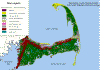
Dune deposits probably started to form about the same time as the saltwater marsh and beach deposits. Dune deposits are made up of sand winnowed from the beaches. Winds carried the sand inland and to the top of sea cliffs, where it was re-deposited as extensive dune fields atop spits and dunes (fig. 4).
The geology of Cape Cod remains dynamic as the postglacial landforms continue to evolve. Wave erosion maintains the sea cliffs cut in the drift. Spits, beaches, and dunes expand and are reshaped by major storms. In response to rises in sea level, plants grow in the marshes and the size of the marshes increases. Eventually, the glacial cape may be worn away and replaced by barrier islands and shoals.
Geology Links:
A
Hypertext in Glacial Geology - Excellent glacial geology
information
A Tapestry of
Time and Terrain
Friends
of the Pleistocene
Geologic
Ages of Earth History - Download the excel spreadsheet
Geology
Wing Entrance (Geologic Time & Plate Tectonics)
Glacial
Geology at the University of Cincinnati
Link to
USGS Glossary of Geologic Terms
Maine
Geology - Glacial Geology Photo Gallery
This
Dynamic Earth (USGS)
URI Geology Department
References:
(3) Kaye, C.A. 1964. Outline of Pleistocene geology of Martha's Vineyard, Massachusetts. U.S. Geol. Surv., Prof. Pap. 501C, pp. C134-Cl39, illus.
(4) Kaye, C.A., and E.S. Barghoorn. 1964. Late Quarternary sea-level change and crustal rise at Boston, Massachusetts, with notes on the autocompaction of peat. Geol. Soc. of Am. Bull. 75: 63-80, illus.
(6) MacConnell, W., D. Swartout, and J. Stone. 1984. Land use update for Cape Cod and the Islands with area statistics for 1951, 1971, and 1980. Massachusetts Agric. Exp. Stn. Res. Bull. 686., 97 pp., illus.
(7) Michilson, D.M., Lee Clayton, D.S. Fullerton, and H.W. Borns, Jr. 1983. The late Wisconsin glacial record of the Laurentide Ice Sheet in the United States. In Late Quaternary environments of the United States, Vol. 1, pp. 3-37, illus.
(8) Oldale, R.N. 1976. Notes on the generalized geologic map of Cape Cod. U.S. Geol. Surv. Unpubl. Rep. 76-765, 23 pp., illus.
(9) Oldale, R.N. 1982. Pleistocene stratigraphy of Nantucket, Martha's Vineyard, the Elizabeth Islands, and Cape Cod, Massachusetts. In Late Wisconsinian glaciation of New England. 34 pp.
(10) Oldale, R.N., and C.J. O'Hara. 1984. Glaciotectonic origin of the Massachusetts coastal end moraines and a fluctuating late Wisconsinan ice margin. Geol. Soc. of Am. Bull. 95: 61-74.
(1 1) Oldale, R.N., and R.A. Barlow. 1986. Geologic map of Cape Cod and the Islands, Massachusetts. U.S. Geol. Surv., Misc. Invest., Map 1-1763, 1 sheet.
(12) Redfield, A.C., and Meyer Rubin. 1962. The age of salt marsh peat and its relation to recent changes in sea level at Barnstable, Massachusetts. Natl. Acad. of Sci. Proc. 48: 1728-1735.
(13) Stone, B.D., and J.D. Peper. 1982. Topographic control of deglaciation of eastern Massachusetts; ice lobation and marine incursion. In Late Wisconsin Glaciation in New England, pp. 145-166.
(17) Zeigler, J.M., S.D. Tuttle, H.J. Tasha, and G.S. Giese. 1965. The age and development of the Provincelands Hook, outer Cape Cod, Massachusetts. In Limnology and oceanography, Vol. 10, Suppl., pp. R298-R311, illus.