Soil Temperature Data for Study Sites
Monitored by the New England Hydric Soils Technical Committee
Other Soil Temp Sites:
Marshfield Ma Site |
Mattapoisett Ma. Site | Franklin County, Ma. Sites |
Histosol Site (Freetown soils) |
Bridgewater Well Site (Raynham Soils)
Rhode Island Soil Climate Data |
Real time
soil temp data from PD Family (Milford MA.) |
Ridgebury Soil, Warwick, RI |
Woodbridge Soil, Chopmist, Hill RI |
Mansfield Soil, Jamestown, RI
Background:
In 2007 the New England Region of the USACE purchased soil temperature
probes (Onset HOBOs) for the New England Hydric Soils Technical Committee (NEHSTC)
to be used to provide data on the growing season for the
regional wetland
supplement. Most of the soil temp loggers were buried at 30 cm (12 in) below
the soil surface and some
also collected data at 50 cm. The loggers ran for 1 to 2 years and data collection is
on-going, information about plant growth (bud score) was recorded by the NEHSTC
but is not provided here. Location of study sites are available on the
Google Earth (Map)
soil observation point file, water table links from the study sites will be
posted shortly.
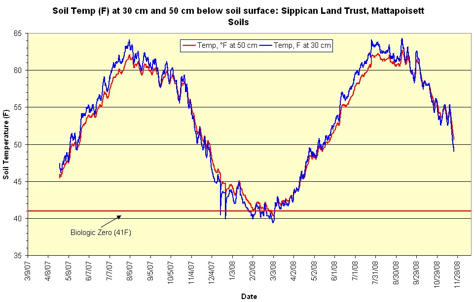
Soil Temperature Study Site: Sippican Land Trust, Town of Mattapoisett Massachusetts - Mattapoisett Soils
| Soil Type: Mattapoisett Sandy, mixed, mesic, ortstein
Typic Epiaquods (Poorly drained soil formed in sandy over loamy till). Mesic Soil
Temperature Regime. Location: Latitude: 41 degrees 41 minutes 32 seconds north Longitude: 70 degrees 45 minutes 43 seconds west Summary: Two loggers were installed at this site, one at 50 cm (20 in) shown in red and the other at 30 cm (12 in) shown in blue on graph below. Soil temp readings were taken ever 5 hours. Data was recorded from April 24, 2007 through November 23, 2008. With the exception of a few minor dips below 41F the growing season ended on January 27, 2008 for the 30 cm probe and February 5, 2008 for the 50 cm probe. Growing season began on March 5, 2008 for both depths. |
_______________________________________________________________________________________________________
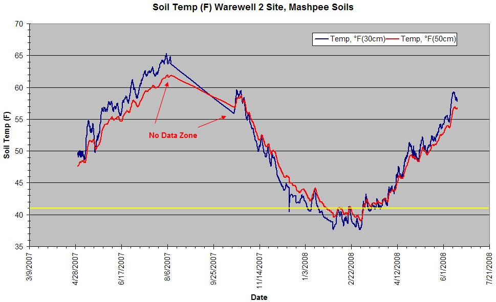
Soil Temperature Study Site: Warewell 2, Town of Wareham Massachusetts - Mashpee Soils
| Soil Type: Mashpee Coarse-loamy, isotic, mesic Typic
Endoaquods (Poorly drained soil formed in sandy outwash). Mesic Soil
Temperature Regime. Pedon Description: http://www.nesoil.com/muds/pedons/2303705.htm Water Table Data: http://www.nesoil.com/obswell/Ware01.htm Location: Latitude: 41 degrees 44 minutes 57.40 seconds north Longitude: 70 degrees 46 minutes 20.90 seconds west Summary: Two loggers were installed at this site, one at 50 cm (20 in) shown in red and the other at 30 cm (12 in) shown in blue on graph below. Soil temp readings were taken ever 5 hours. Data was recorded from May 2, 2007 through August 10 and again from October 17, 2007 through June 16 2008. With the exception of a few minor dips below 41F the growing season ended on January 18 2008 for the 30 cm probe and January 29 for the 50 cm probe and the growing season started for both probes on March 5th. |
_______________________________________________________________________________________________
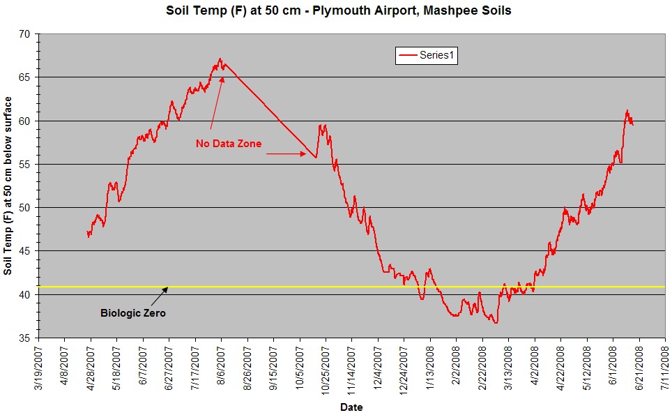
Soil Temperature Study Site: Plymouth Massachusetts Airport - Mashpee Soils
| Soil Type: Coarse-loamy, isotic, mesic Typic
Endoaquods (Poorly drained soil formed in sandy outwash). Mesic Soil
Temperature Regime. Pedon Description: Check Back Water Table Data: Check Back Location: Latitude: 41 degrees 54 minutes 02.65 seconds north, Longitude: 70 degrees 44 minutes 29.19 seconds west Summary: A Hobo Logger was installed at 50 cm (20 in) below the soil surface (another logger was installed at 14.5 cm below surface but data is not provided here). Soil temp readings were taken ever 5 hours. Data was recorded from May 25, 2007 through June 16, 2008 no data was recorded between 8/9 to 10/17 2007 (no data zone). With the exception of a few minor dips below 41F the growing season ended on January 19, 2008 and began again on April 1, 2008. |
__________________________________________________________________________________________________
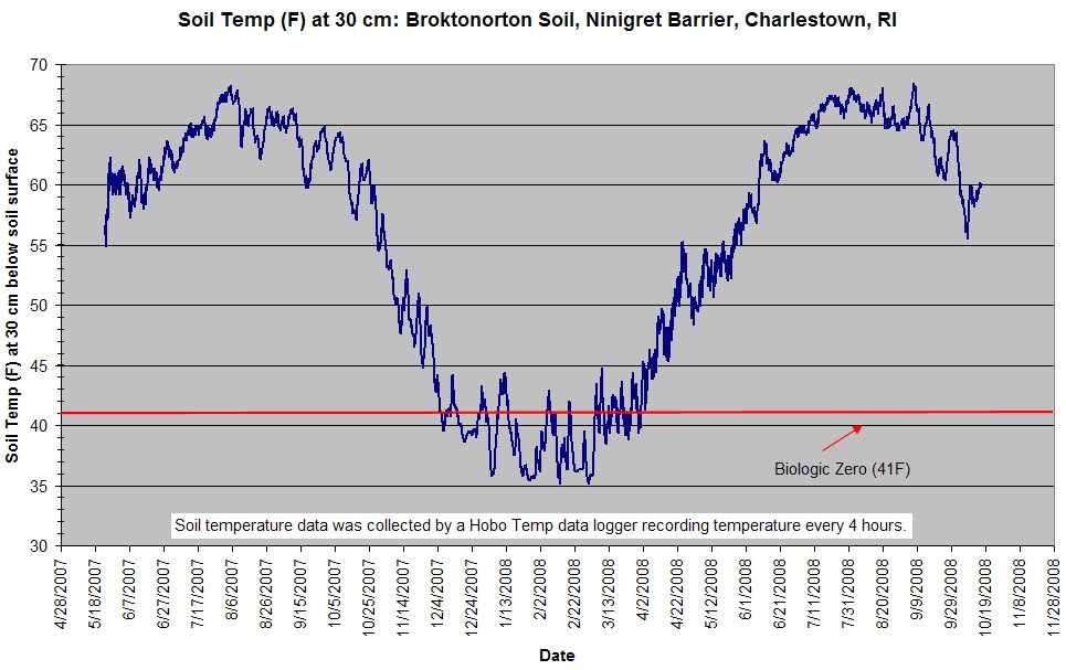
Soil Temperature Study Site: Ninigret Barrier, Charlestown, RI - Brocktonorton Soils
| Soil Type: Brocktonorton - moderately well drained
soils on back barrier coastal dunes. Mesic Soil Temperature
Regime. Pedon Description: Check Back Water Table Data: Check Back Location: Latitude: 41 degrees 20 minutes 42.06 seconds north Longitude: 71 degrees 41 minutes 11.17 seconds west Summary: A Hobo Logger was installed at 30 cm (12 in) below the soil surface. Soil temp readings were taken ever 4 hours. Data was recorded from May 26, 2007 through October 17 2008. With the exception of a few minor dips below 41F the growing season ended on December 16 2007 and began on April 1 2008. |
_______________________________________________________________________________________________
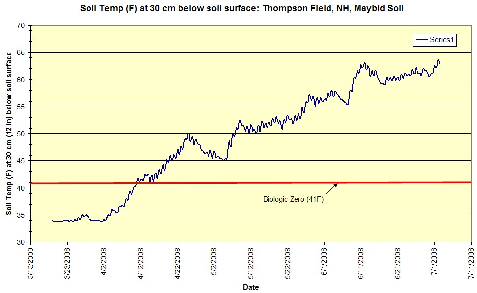
Soil Temperature Study Site: Thompson Farm, Durham, NH - Maybid Soils
| Soil Type: Maybid (VPD lacustrine soils). Mesic Soil Temperature
Regime (borderline frigid zone). Pedon Description: Check Back Water Table Data: Check Back Location: 43.10997N, 70.95256W Summary: A Hobo Logger was installed at 30 cm (12 in) below the soil surface. Soil temp readings were taken ever 5 hours. Data was recorded from March 19, 2008 through July 2, 2008. With the exception of a few minor dips below 41F the growing season began on April 10 2008. |
Soil Temperature
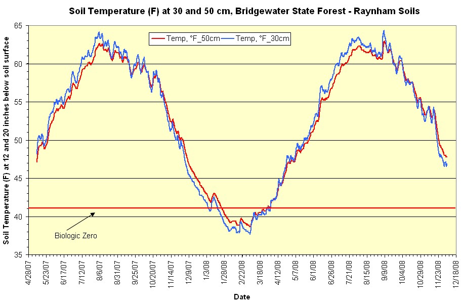
Study Site: Bridgewater Massachusetts, State Forest - Raynham Soils
Data for a nearby site from 1992-1993
| Soil Type: Raynham (PD lacustrine soils). Mesic Soil Temperature
Regime. Pedon Description: Check Back Water Table Data: Check Back Location: 41 59' 05"N, 70 56' 59"W Summary: Two loggers were installed at this site, one at 50 cm (20 in) shown in red and the other at 30 cm (12 in) shown in blue on graph below. Soil temp readings were taken ever 5 hours. Data was recorded from May 9, 2007 through December 5, 2008. The growing season ended (soil temp. dropped below 41F) on January 20, 2008 for the 30 cm logger and January 25 2008 for the 50 cm probe. Growing seasons began on April 1, 2008 for both depths. |
________________________________________________________________________________
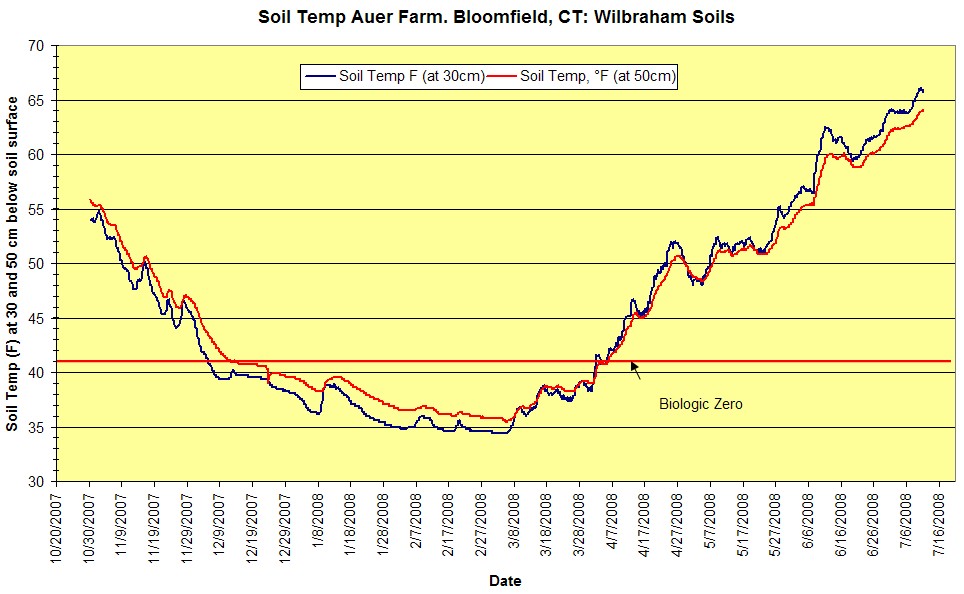
Soil Temperature Study Site: Auer Farm, Bloomfield, CT - Wilbraham Soils
| Soil Type: Wilbraham, Coarse-loamy, mixed, active,
mesic Aquic Dystrudepts . Mesic Soil Temperature
Regime. Pedon Description: Check Back | OSED: http://www2.ftw.nrcs.usda.gov/osd/dat/W/WILBRAHAM.html Water Table Data: Check Back Location: 41 degrees 48 minutes, 46.39 seconds North, 72 degrees, 46 minutes, 12.31 seconds West (est). Summary: A Hobo Logger was installed at 30 cm (12 in) and 50 cm (20 in) below the soil surface. Soil temp readings were taken ever 5 hours. Data was recorded from October 31, 2007 through July 11, 2008. The growing season ended 12\6\2007 for the 30 cm logger and 12\14\2007 for the 50 cm logger and began on April 6 2008 for both loggers. |
Back to Nesoil climate page
Back to Nesoil