The following map unit description is from the published "Soil Survey of Dukes County, Massachusetts"
Soil Survey of
Dukes County Massachusetts
The following map unit description is from the published "Soil
Survey of Dukes County, Massachusetts"
CeA-Carver loamy coarse sand, 0 to 3 percent slopes. This soil is very deep, nearly level, and excessively drained. It is in large, broad areas on outwash plains mostly in the central and eastern parts of Martha's Vineyard. The areas of this soil are irregular in shape and range from 5 to 1,500 acres. They make up about 11 percent of the survey area.
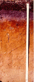
Typically, the surface layer is dark grayish brown loamy coarse sand about 3 inches thick. The subsurface layer is light brownish gray loamy coarse sand about 1 inch thick. The subsoil is about 26 inches thick. The upper 10 inches of the subsoil is strong brown loamy coarse sand, and the lower 16 inches is brownish yellow coarse sand. The substratum is light yellowish brown coarse sand to a depth of 60 inches or more.
Included with this soil in mapping are small areas of Eastchop, Haven, Klej, and Riverhead soils. Also included are soils that have a subsoil and substratum of gravelly coarse sand and small areas of soils with slopes of 3 to 8 percent. Included areas make up about 20 percent of this unit.
The permeability of this Carver soil is very rapid throughout. Available water capacity is very low. This soil is droughty in late summer. The depth to the seasonal high water table is more than 6 feet.
Most areas of this soil are in woodland. Some areas are in cropland; and some are in residential development.
This soil is poorly suited to cultivated crops and hay and pasture because of the very low available water capacity. Mixing crop residue and manure into the surface layer helps to retain the limited available water, maintain tilth, and increase the organic matter content. The use of proper stocking rates and deferred and rotational grazing help to maintain desirable pasture plant species.
This soil is poorly suited to woodland productivity because of droughtiness. Thinning crowded stands, especially those that contain undesirable species, will help to increase growth of desirable species. The common trees on this soil are pitch pine, scrub oak, scarlet oak, black oak, and white oak.
This soil has few limitations for use as a site for buildings with or without basements. The droughtiness of this soil is a limitation for lawns, shallow-rooted trees, and shrubs. Adding a layer of topsoil and frequent watering during dry periods will help to overcome this limitation. In some areas this soil does not adequately filter effluent from septic tank absorption fields, causing a hazard of pollution to ground water. Low density housing reduces the volume of effluent, thus lessening the pollution hazard.
This soil is in capability subclass IVs.
CeB-Carver loamy coarse sand, 3 to 8 percent slopes. This soil is very deep, gently sloping, and excessively drained. It is in large, broad areas on the outwash plain and terminal moraines, mostly in the northern, central, and eastern parts of Martha's Vineyard. The areas of this soil are irregular in shape and range from 5 to 1,000 acres. They make up about 15 percent of the survey area.
Typically, the surface layer is dark grayish brown loamy coarse sand about 3 inches thick. The subsurface layer is light brownish gray loamy coarse sand about 1 inch thick. The subsoil is about 26 inches thick. The upper 10 inches of the subsoil is strong brown loamy coarse sand, and the lower 16 inches is browt1ish yellow coarse sand. The substratum is light yellowish brown coarse sand to a depth of 60 inches or more.
Included with this soil in mapping are small areas of Eastchop, Haven, Klej, and Riverhead soils. Also included are soils that have a subsoil and substratum of gravelly coarse sand and small areas of soils with slopes of 0 to 3 percent and 8 to 15 percent. A few small areas, generally at the base of swales, have a redder subsoil and substratum than this Carver soil has. Included areas make up about 20 percent of this unit.
The permeability of this Carver soil is very rapid throughout. Available water capacity is very low. This soil is droughty in late summer. The depth to the seasonal high water table is more than 6 feet.
Most areas of this soil are in woodland. Some areas are in cropland, and some are in residential development.
This soil is poorly suited to cultivated crops and hay and pasture because of the very low available water capacity. Mixing crop residue and manure into the surface layer helps to retain the limited available water , maintain tilth, and increase the organic matter content. The use of proper stocking rates and deferred and rotational grazing help to maintain desirable pasture plant species.
This soil is poorly suited to woodland productivity because of droughtiness. Thinning crowded stands, especially those that contain undesirable species, will help to increase growth of desirable species. The common trees on this soil are pitch pine, scrub oak, scarlet oak, black oak, and white oak.
This soil has few limitations for use as a site for buildings with or without basements. The droughtiness of this soil is a limitation for lawns, shallow-rooted trees, and shrubs. Adding a layer of topsoil and frequent watering during dry periods will help to overcome this limitation. In some areas this soil does not adequately filter effluent from septic tank absorption fields, causing a hazard of pollution to ground water. Low density housing reduces the volume of effluent, thus lessening the pollution hazard.
This soil is in capability subclass IVs.
CeC-Carver loamy coarse sand, 8 to 15 percent slopes. This soil is very deep, strongly sloping, and excessively drained. It is on small hills and ridges on moraines and on the side slopes of swales on the outwash plain. Most areas are in the northern and eastern parts of Martha's Vineyard. The areas of this soil are irregular in shape and range from 5 to 200 acres. They make up about 7 percent of the survey area.
Typically, the surface layer is dark grayish brown loamy coarse sand about 3 inches thick. The subsurface layer is light brownish gray loamy coarse sand about 1 inch thick. The subsoil is about 26 inches thick. The upper 10 inches of the subsoil is strong brown loamy coarse sand, and the lower 16 inches is brownish yellow coarse sand. The substratum is light yellowish brown coarse sand to a depth of 60 inches or more.
Included with this soil in mapping are small areas of Riverhead and Klej soils. Also included are soils that have subsoil and substratum of gravelly coarse sand and small areas of soils with slopes of 3 to 8 percent and 15 to 30 percent. Some small areas, generally at the base of swales, have a redder subsoil and substratum than this Carver soil has. Included areas make up about 25 percent of this unit.
The permeability of this Carver soil is very rapid throughout. Available water capacity is very low. This soil is droughty in late summer. The depth to the seasonal high water table is more than 6 feet.
Most areas of this soil are in woodland. Some areas are used for pasture and hay, and some are in residential development.
The very low available water capacity, slope, and a hazard of erosion make this soil generally unsuitable for cultivated crops and hay and pasture.
This soil is poorly suited to woodland productivity because of droughtiness. Thinning crowded stands, especially those that contain undesirable species, will help to increase growth of desirable species. The common trees on this soil are pitch pine, scrub oak, scarlet oak, black oak, and white oak.
Slope limits the use of this soil as a site for buildings; land shaping is generally needed. Establishing plant cover as soon as possible helps to control erosion on slopes at construction sites. This soil is limited as a site for septic tank absorption fields because of the slope and because in some areas the soil does not adequately filter the effluent, making pollution of ground water a hazard. Low density housing reduces the volume of effluent, thus lessening the pollution hazard. Installing septic tank distribution lines on the contour or in areas that were graded during construction will help to overcome the slope.
This soil is in capability subclass VIIs.
CeD-Carver loamy coarse sand, 15 to 25 percent slopes. This soil is very deep, moderately steep, and excessively drained. It is on hills and ridges on moraines and on the side slopes of swales on outwash plains. The areas of this soil are irregular in shape and range from 5 to 50 acres. They make up about 2 percent of the survey area.
Typically, the surface layer is dark grayish brown loamy coarse sand about 3 inches thick. The subsurface layer is light brownish gray loamy coarse sand about 1 inch thick. The subsoil is about 26 inches thick. The upper 10 inches of the subsoil is strong brown loamy coarse sand, and the lower 16 inches is brownish yellow coarse sand. The substratum is light yellowish brown coarse sand to a depth of 60 inches or more.
Included with this soil in mapping are areas of Riverhead, Klej, Pompton, and Berryland soils. Also included are areas of soils that have a subsoil and substratum of gravelly coarse sand and soils with slopes of O to 3 percent and 8 to 15 percent. Included areas make up about 25 percent of this unit.
The permeability of this Carver soil is very rapid throughout. Available water capacity is very low. This soil is droughty in late summer. The depth to the seasonal high water table is more than 6 feet.
The very low available water capacity, slope, and a severe hazard of erosion make this soil generally unsuitable for cultivated crops and hay and pasture.
Most areas are wooded, but the soil is poorly suited to woodland productivity because of droughtiness. Thinning crowded stands, especially those that contain undesirable species, will help the growth of desirable species. The hazard of erosion is a management concern, particularly in disturbed areas such as skid trails, landings, and access roads. Constructing access roads and trails at a slope of 2 to 10 percent and installing water bars will help to prevent erosion. The common trees on this soil are pitch pine, scrub oak, scarlet oak, black oak, and white oak.
Slope limits the use of this soil as a site for buildings; land shaping is generally needed. Establishing plant cover as soon as possible helps to control erosion on slopes at construction sites. This soil is limited as a site for septic tank absorption fields because of the slope and because the soil in some areas does not adequately filter the effluent, making pollution of ground water a hazard. Low density housing reduces the volume of effluent, thus lessening the pollution hazard. Installing septic tank distribution lines on the contour or in areas that were graded during construction will help to overcome the slope.
This soil is in capability subclass VIIs.
Back to Dukes County Soil Survey