Hydric Soil's
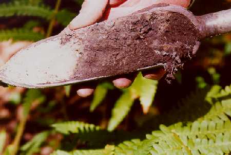
Hydric Soil Definition: A hydric soil is a soil that formed under conditions of saturation, flooding, or ponding long enough during the growing season to develop anaerobic conditions in the upper part. Hydric soils along with hydrophytic vegetation and wetland hydrology are used to define wetland boundaries.
Official hydric soil lists can be found on the Hydric Soil Page
Growing Season Definition: The 1987 USACOE Wetlands Delineation Manual (Technical Report Y-87-1) - glossary, Appendix A defines growing season as the portion of the year when soil temperature (measured at 12 inches below the surface) is above biological zero (5C or 41F). This period "can be approximated by the number of frost-free days." Estimated starting and ending dates for growing season are based on 28F air temperature thresholds at a frequency of 5 years in 10. Click here for the climate tables used for growing season determination (WETS Tables).
NOTE: Refer to Regional Supplements for wetland delineation information.
|
|
|
Hydric Soils - Criteria (Note: Hydric Soil Criteria is designed to generate a list of hydric soils from the national database of soils interpretation records. Criteria is not intended for field identification of hydric soils, except criteria 1, 3 and 4).
The following criteria reflect those soils that are likely to meet the definition of hydric soils. Criteria 1, 3, and 4 serve as both database criteria and as indicators for identification of hydric soils. Criterion 2 serves only to retrieve soils from the database. In addition, the wording of criteria 1 and 2 were changed in 2000 to incorporate recent changes in Soil Taxonomy ( Soil Survey Staff, 1999). Please note that these changes did not cause any soils to be added or deleted from the list.
a. Somewhat poorly drained with a water table* equal to 0.0 foot (ft) from the surface during the growing season, or
b. Poorly drained or
very poorly drained and have
either:
Clarification of terms for 3 and 4:
1. Frequently -- at least 5 years in 10, or 50% probability in any one year.
2. Long duration -- a single event lasts 7 to 30 days.
3. Very long duration -- a single event lasts more than 30 days.
Ponding. Standing water on soils in closed depressions. Unless the soils are artificially drained, the water can be removed only by percolation or evapotranspiration.
Flooding: Accumulation of large amounts of runoff on the landscape as a result of rainfall in excess of the soil's ability to drain water from the landscape before extensive inundation and ponding occurs.
*water table: the upper surface of ground water where the water is at atmospheric pressure. In the Map Unit Interpretation Record (MUIR) database, entries are made for the zone of saturation at the highest average depth during the wettest season. It is at least six inches thick and persists in the soil for more than a few weeks. In other databases, saturation, as defined in Soil Taxonomy (Soil Survey Staff. 1999), is used to identify conditions that refer to water table in Criteria 2.
Visit: NRCS Hydric Soil Page for more information about hydric soils.
History, Classification, Rational, Criteria of of Hydric Soils
New England
Indicators of Hydric Soils - Download a PDF copy free.
NE Interstate Water
Pollution Control Commission
PLANTS National Database
Society of Wetland Scientists
WETs Climate Tables (growing
season info).
IRIS Tube - Indicator of
Reduction in Soils (IRIS)tubes visually reflect currenthydric soil conditions
caused by recent anaerobic and reducingprocesses. IRIS devices can identify
hydric soils in wetlands,investigate depth of saturation in soils, identify
failed septicsystems, and qualitatively analyze soil organic carbon content.