Glacial Fluvial Landform
Download soil profile locations for viewing with Google Earth
(500 KB KMZ file, requires Google Earth to be installed).
NEsoil.com Images
Glacial Fluvial Landform
Download soil profile locations for viewing with
Google Earth
(500 KB KMZ file, requires
Google Earth to be installed).
![]() (Link to Site)
(Link to Site)
Material moved by glaciers and subsequently sorted and deposited by streams flowing from the melting ice. The deposits are stratified and may occur in the form of outwash plains, valley trains, deltas, kames, eskers, and kame terraces.
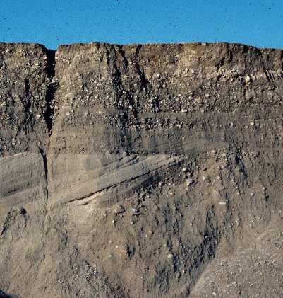
An outcrop of a fluvial deposit (click for bigger image)
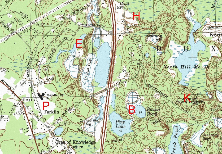
Above: An example of a glacial fluvial landform (Duxbury USGS Topographic Quadrangle).
B - Kettle Pond and
Bogs formed by blocks of glacial ice that detached from the receding glacier,
became covered with fluvial sediments, and later melted forming a basin. The
basin either filled with water (kettle pond), filled with organic material
(kettle bog), or if it didn't intercept the water table; remained a dry kettle
hole.
E - Esker - A long, narrow, sinuous
and steep-sided ridge composed of irregularly stratified sand and gravel
deposited as the bed of a stream flowing in an ice tunnel within or below the
ice (subglacial) or between ice walls on top of the ice (ice channel filling) of
a wasting glacier, and left behind as high ground when the ice melted.
H - Head of Outwash (Ice-contact
head) - A sloping and sometimes high relief landform composed predominantly of glaciofluvial sediment that delimits a former ice-margin of a relatively static,
rapidly wasting glacier. A steep ice-contact slope forms the ice-proximal
face of the landform; a more gently sloping surface dips away on the distal
slope, if not slumped.
K - Kame - A mound, knob, hummock,
or short irregular ridge, composed of stratified sand and gravel deposited by a
subglacial stream as a fan or delta at the margin of a melting glacier; by a
supraglacial stream in a low place or hole on the surface of the glacier; or as
a ponded deposit on the surface or at the margin of stagnant ice.
P - Outwash Plain - An extensive
lowland area of coarse textured, glacial fluvial material. An outwash plain is
commonly smooth; where pitted, due to melt-out of incorporated ice masses
(pitted outwash plain), it is generally low in relief and largely retains it's
original gradient.