Note: Squamscott Soils are mapped with the non-spodic Enosburg Series in Plymouth County
Click here for a photo of this pedon
Site Record ID: 10
Pedon Record ID: 10
Pedon ID: MA023-2007-02104-Squamscott (Deep)-P
Site ID: MA023-2007-02104-Squamscott (Deep)-S
Description Date: 11/5/2007
Print Date: 11/29/2007
Describer: Rob Tunstead and Melissa Hayden
Site Notes:
Pedon Notes:
Text: Depth to 2C is outside of particle size control section which is typical within the soil survey update area. The series currently recognized within the survey update area is Enosburg. This may have to change upon approval of the map unit.
Text: A grab sample of the spodic horizon was retrieved to run percent iron by ammonium oxalate.
Soil Name As Described/Sampled: Squamscott (Deep)
Soil Name As Correlated:
Classification: Sandy, mixed, mesic Aeric Alaquods
Pedon Type: Modal pedon for map unit
Pedon Purpose: Full pedon description
Taxon Kind: Series
SSURGO MU: 21A - Enosburg fine sandy loam
Non-MLRA Soil Survey Area: MA023 - Plymouth County, Massachusetts
Land Resource Region: R - Northeastern Forage and Forest Region
MLRA: 144A - New England and Eastern New York Upland, Southern Part
MLRA Soil Survey Area: SS144A - New England and Eastern New York Upland, Southern Part MLRA Soil Survey
County or Parish: MA023 - Plymouth
State or Territory: MA - Massachusetts
Country: US - United States
7.5' Quad: 41070-H8 - Bridgewater, Massachusetts
MLRA Region Office Area: 12 - Amherst, MA
Physiographic Division: AH - Appalachian Highlands
Physiographic Province: NE - New England Province
Physiographic Section: SLS - Seaboard lowland section
Lat/Long: 41°57’23.1” north, 70°55’18.4” west
UTM: 340726E, 4646730N -- Datum NAD83, Zone 19
http://www.topozone.com/map.asp?lat=41.95648&lon=-70.92184&datum=nad83&u=4&layer=DRG&size=l&s=50
Location Description: In the town of Middleborough 81.3 meters due north of River Street, 81 meters north-northwest of entrance to Rod and Gun club, and 304 meters southwest of the Taunton River.
Legal Description:
Landscape: lake plain
Landform: glacial lake
Microfeature:
Anthropogenic Feature:
Geomorphic Component: Tread
Profile Pos: Footslope: on lower third
Slope: 2 percent
Elevation: 10.4 meters
Aspect: 295°
Shape: up/down: Linear; across: Linear
Complexity: Simple
Flooding:
Ponding: Occasional; brief; Jan
Drainage: Poorly drained
Runoff: Low
Permeability: Moderately rapid
Erosion: None - deposition
Primary Earth Cover: Tree cover; Secondary Earth Cover: Intermixed conifers and hardwoods
Existing Vegetation: CLAL3 - coastal sweetpepperbush (Clethra alnifolia); PIST - eastern white pine (Pinus strobus); CHIMA - prince's pine (Chimaphila); VACO - highbush blueberry (Vaccinium corymbosum); QUERC - oak (Quercus); OSCI - cinnamon fern (Osmunda cinnamomea); SMILA2 - greenbrier (Smilax); 2MOSS - Moss
Parent Materials: sandy glaciofluvial deposits over coarse-silty glaciolacustrine deposits
Surface Fragments:
Bedrock:
Particle Size Control Section: 25 to 100 centimeters
Diagnostic Features: Ochric epipedon: 0 to 60 centimeters, Aquic conditions: 0 to 170 centimeters, Hemic soil material: 0 to 10 centimeters, Sapric soil material: 10 to 16 centimeters, Albic horizon: 24 to 60 centimeters, Spodic horizon: 60 to 98 centimeters and Abrupt textural change: 129 centimeters (Restrictive layer)
| Slope | Elevation | Aspect | MAAT | MSAT | MWAT | MAP | Frost-Free Days | Drainage Class | Slope Length | Upslope Length |
|---|---|---|---|---|---|---|---|---|---|---|
| 2 percent | 10.4 meters | 295° | 1197 millimeters | poorly |
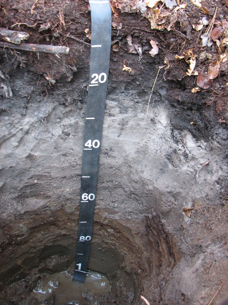
Oa --- 10 to 16 centimeters; black (10YR 2/1) moist, broken face, highly decomposed plant material; weak fine granular structure; very friable; many very coarse roots throughout, many coarse roots throughout, many medium roots throughout, many fine roots throughout and many very fine roots throughout; very strongly acid, pH 5, Chlorophenol red; clear smooth boundary. AE --- 16 to 24 centimeters; 70 percent black (10YR 2/1) moist, interior, 20 percent very dark gray (10YR 3/1) moist, interior and 10 percent dark gray (10YR 4/1) moist, interior, fine sandy loam; gray (10YR 5/1) dry, interior; weak coarse subangular blocky and weak medium subangular blocky and weak fine subangular blocky structure; friable; common coarse roots throughout, many medium roots throughout, many fine roots throughout and many very fine roots throughout; Chlorophenol red pH method; 10 - 15 percent stripped sand grains were observed in the horizon. pH was off the chart and could not be determined.; abrupt smooth boundary. Eg1 --- 24 to 39 centimeters; 45 percent gray (7.5YR 5/1) moist, interior and 45 percent dark gray (7.5YR 4/1) moist, interior, gravelly fine sand; weak very coarse subangular blocky and weak coarse subangular blocky and weak medium subangular blocky and weak fine subangular blocky structure; friable; common fine roots throughout and common very fine roots throughout; 8 percent (common) medium distinct irregular noncemented gray (10YR 6/1), moist, iron depletions clear throughout and 2 percent (common) medium faint irregular noncemented very dark gray (7.5YR 3/1), moist, iron depletions clear throughout; 5 percent subrounded 2 to 75 millimeters coarse gravel sized mixed rock fragments; Chlorophenol red pH method; pH like the horizon above was off the charts for the field kit I have. Many different colors were observed in the horizon indicative of hydromorphic features and the leaching of iron, organic matter, manganese, and / or aluminum.; clear wavy boundary. Eg2 --- 39 to 60 centimeters; 80 percent dark gray (7.5YR 4/1) moist, interior, gravelly sand; weak medium subangular blocky and weak fine subangular blocky structure; very friable; moderately few fine roots throughout and moderately few very fine roots throughout; 5 percent (common) medium faint irregular noncemented very dark gray (10YR 3/1), moist, iron depletions clear throughout and 15 percent (common) medium distinct irregular noncemented gray (10YR 6/1), moist, iron depletions clear throughout; 5 percent subrounded 2 to 75 millimeters coarse gravel sized mixed rock fragments; Chlorophenol red pH method; pH could not be recorded as it was off the charts for the field kit used. Many different colors were observed indicative of hydromorphic features within the horizon.; abrupt smooth boundary. Bhs --- 60 to 77 centimeters; 50 percent very dark brown (7.5YR 2.5/2) moist, interior, 35 percent dark brown (7.5YR 3/3) moist, interior and 15 percent reddish black (2.5YR 2.5/1) moist, interior, gravelly sand; massive; friable; moderately few fine roots in mat at top of horizon and moderately few very fine roots in mat at top of horizon; 20 percent subrounded 2 to 76 millimeters coarse gravel sized mixed rock fragments; strongly acid, pH 5.4, Chlorophenol red; Many different colors observed in the horizon indicative of hydromorphic features or translocation of iron, organic matter, manganese, and / or aluminum. The horizon was firm in place indicative of some cementation by organic matter and aluminum.; clear smooth boundary. Bs --- 77 to 98 centimeters; dark yellowish brown (10YR 4/4) moist, interior, fine sand; massive; very friable; strongly acid, pH 5.2, Chlorophenol red; clear wavy boundary. Bg --- 98 to 129 centimeters; gray (5Y 5/1) moist, interior, fine sand very fine sand; massive; very friable; moderately acid, pH 5.8, Chlorophenol red; clear wavy boundary. 2Cg --- 129 to 170 centimeters; greenish gray (10Y 5/1) moist, interior, silt loam; massive; friable; 5 percent (common) coarse prominent irregular noncemented dark olive brown (2.5Y 3/3), moist, masses of oxidized iron sharp throughout and 5 percent (common) medium prominent irregular noncemented dark olive brown (2.5Y 3/3), moist, masses of oxidized iron sharp throughout; positive reaction to alpha-alpha' dipyridyl; moderately acid, pH 5.8, Chlorophenol red; Lithologic discontinuity depth of 129cm is approximate as material was examined with a bucket auger..
![]()