Ninigret Pond Soil Pedon Description: S04-RI-009-003 (Site X – Mainland Cove)
Quick Link:
Site Information
Pedon Description
Map Unit Description
XRF Heavy Metal Analysis
Core Analyzer Data
Soil Profile Image
| Print Date: | 11/08/2004 | ||||||||||||||||||||||||||||||||||||||||||||||||||||
| Description Date: | 09/01/2004 | ||||||||||||||||||||||||||||||||||||||||||||||||||||
| Describer: | Mike Bradley, Jim Turenne | ||||||||||||||||||||||||||||||||||||||||||||||||||||
| Site ID: | Site X | ||||||||||||||||||||||||||||||||||||||||||||||||||||
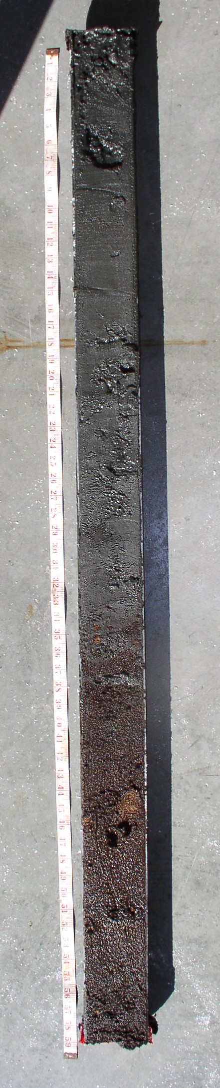
| Site Notes: | Hammer Core Sample – 4 in Polycarbonate tube, sampled to 164 cm. Core was analyzed/imaged by GSO using a Geo Tek Core Analyser, data available. | ||||||||||||||||||||||||||||||||||||||||||||||||||||
| Pedon ID: | S04-RI-009-003 | ||||||||||||||||||||||||||||||||||||||||||||||||||||
| Pedon Notes: | Soil consists of 96 cm of lagoon-bottom deposits overlying buried organic material interpreted as an Atlantic White Cedar swamp kettle hole. Nearby area found the organics to be > 20 feet thick. | ||||||||||||||||||||||||||||||||||||||||||||||||||||
| Lab Source ID: | |||||||||||||||||||||||||||||||||||||||||||||||||||||
| Lab Pedon #: | Site X | ||||||||||||||||||||||||||||||||||||||||||||||||||||
|
|||||||||||||||||||||||||||||||||||||||||||||||||||||
| Pedon Type: | |||||||||||||||||||||||||||||||||||||||||||||||||||||
| Pedon Purpose: | Ninigret Pond subaqueous soil survey pilot project. | ||||||||||||||||||||||||||||||||||||||||||||||||||||
| Taxon Kind: | |||||||||||||||||||||||||||||||||||||||||||||||||||||
| Associated Soils: | Lagoon Bottom | ||||||||||||||||||||||||||||||||||||||||||||||||||||
| Location Information | |||||||||||||||||||||||||||||||||||||||||||||||||||||
| Country: | USA | ||||||||||||||||||||||||||||||||||||||||||||||||||||
| State: | RI | ||||||||||||||||||||||||||||||||||||||||||||||||||||
| County: | Washington | ||||||||||||||||||||||||||||||||||||||||||||||||||||
| MLRA: | 149B | ||||||||||||||||||||||||||||||||||||||||||||||||||||
| Soil Survey Area: | RI600-009 | ||||||||||||||||||||||||||||||||||||||||||||||||||||
| Quad Name: | Qunochontaug | ||||||||||||||||||||||||||||||||||||||||||||||||||||
| Location Description: | Ninigret Pond, Charleston, RI. Ft. Neck Cove west-central area near shore. | ||||||||||||||||||||||||||||||||||||||||||||||||||||
| Legal Description: | |||||||||||||||||||||||||||||||||||||||||||||||||||||
| Latitude: | 41 degrees 22 minutes 15.53 seconds north | ||||||||||||||||||||||||||||||||||||||||||||||||||||
| Longitude: | 71 degrees 39 minutes 8.12 seconds west | ||||||||||||||||||||||||||||||||||||||||||||||||||||
| Datum: | NAD83 | ||||||||||||||||||||||||||||||||||||||||||||||||||||
| UTM Zone: | 19 | ||||||||||||||||||||||||||||||||||||||||||||||||||||
| UTM Easting: | 278186 meters | ||||||||||||||||||||||||||||||||||||||||||||||||||||
| UTM Northing: | 4583335 meters | ||||||||||||||||||||||||||||||||||||||||||||||||||||
|
|||||||||||||||||||||||||||||||||||||||||||||||||||||
Climate Data:
|
Slope (%) |
Elevation (feet) |
Aspect (deg) |
MAAT (F) |
MSAT (F) |
MWAT (F) |
MAP (in) |
Frost Free Days |
Drainage Class |
Slope Length (feet) |
Upslope Length (feet) |
|
|
|
|
|
|
|
|
|
very poorly |
|
|
A1--0 to 5 centimeters (0.0 to 2.0 inches); black (5Y 2.5/1) interior, silt loam; massive; loose, nonsticky, nonplastic; very fluid; extremely low penetration resistance; low excavation difficulty; negative reaction to alpha-alpha' dipyridyl; gradual boundary. Moderate hydrogen sulfide odor, n value = >>1.
C1--5 to 55 centimeters (2.0 to 21.7 inches); black (5Y 2.5/1) interior, silt loam; massive; loose, nonsticky, nonplastic; moderately fluid; extremely low penetration resistance; low excavation difficulty; negative reaction to alpha-alpha' dipyridyl; gradual. Slight hydrogen sulfide odor, n value = 1.
C2--55 to 88 centimeters (21.7 to 34.6 inches); black (5Y 2.5/1) interior, silt loam; massive; loose, nonsticky, nonplastic; moderately fluid; extremely low penetration resistance; low excavation difficulty; negative reaction to alpha-alpha' dipyridyl; gradual boundary. Slight hydrogen sulfide odor, n value = 1.
C/O--88 to 96 centimeters (34.6 to 37.8 inches); 65 percent black (5Y 2.5/1) interior and 35 percent black (7.5YR 2.5/1) rubbed, silt loam and muck; massive; very friable, nonsticky, nonplastic; moderately fluid; extremely low penetration resistance; low excavation difficulty; 1 percent nonflat subrounded noncemented wood fragments; negative reaction to alpha-alpha' dipyridyl; abrupt boundary.
2Oa--96 to 164 centimeters (37.8 to 64.6 inches); dark brown (7.5YR 3/3) interior and black (5YR 2.5/1) oxidized and dark brown (7.5YR 3/2) rubbed, muck; loose, nonsticky, nonplastic; very fluid; extremely low penetration resistance; low excavation difficulty; negative reaction to alpha-alpha' dipyridyl. NOTE: organic material was greater than 20 feet thick in area.
Mc(A) – Mainland Cove, 1 – 2% slopes: These soils are found in protected coves along the mainland shoreline. The subaqueous soils of this unit are characterized by black, very dark gray, and dark gray, loamy sand, fine sandy loams and silt loam. Two types of buried organic horizons (30% organic carbon) are found at depths of 50 cm – 80 cm. Reddish black organic horizons are probably remnants of buried Pleistocene-aged Atlantic white cedar swamps. The dramatic decrease in salinity of these layers supports this origin. Yellowish black buried organic horizons are probably indicative of salt marsh peat. Most soils are classifed as Thapto-histic Hydraquents. Water depths are 1.4 m or less. Submerged topography is gently sloping (1%). Eelgrass cover is moderate (10-50%).
Core XRF Data (analyzed with a Niton XRF Unit - <LOD = limit of detection):
|
Units |
Depth from Surface(in) |
Sample |
Mo |
Zr |
Sr |
Rb |
Pb |
Se |
As |
Hg |
Zn |
Cu |
Ni |
Co |
Fe |
Mn |
Cr |
|
ppm |
-5 |
X 5IN |
< LOD : 2.07 |
41.49 |
49.52 |
40.39 |
28.69 |
< LOD : 8.33 |
< LOD : 14.02 |
< LOD : 10.37 |
< LOD : 39.63 |
< LOD : 53.85 |
< LOD : 61.94 |
< LOD : 100.06 |
5680.33 |
< LOD : 101.50 |
< LOD : 99.30 |
|
ppm |
-8 |
X 8IN |
< LOD : 1.92 |
22.35 |
31.04 |
22.36 |
15.47 |
< LOD : 7.52 |
< LOD : 12.04 |
< LOD : 9.11 |
< LOD : 34.04 |
< LOD : 48.64 |
< LOD : 58.76 |
< LOD : 90.54 |
4911.97 |
< LOD : 87.42 |
< LOD : 85.82 |
|
ppm |
-18 |
X 18IN |
< LOD : 1.96 |
17.33 |
36.79 |
32.16 |
< LOD : 12.43 |
< LOD : 8.07 |
< LOD : 12.51 |
< LOD : 10.03 |
< LOD : 38.40 |
< LOD : 51.98 |
< LOD : 64.88 |
< LOD : 119.86 |
8183.2 |
131.63 |
< LOD : 96.05 |
|
ppm |
-24 |
X 24IN |
< LOD : 2.36 |
59.93 |
42.89 |
43.4 |
< LOD : 13.71 |
< LOD : 9.42 |
< LOD : 13.44 |
< LOD : 11.19 |
< LOD : 42.15 |
< LOD : 60.51 |
< LOD : 71.06 |
< LOD : 147.43 |
12048.11 |
< LOD : 120.99 |
< LOD : 116.09 |
|
ppm |
-34 |
X 34IN |
< LOD : 2.59 |
187.24 |
39.23 |
33.47 |
< LOD : 14.13 |
< LOD : 9.13 |
< LOD : 14.09 |
< LOD : 10.90 |
< LOD : 43.09 |
< LOD : 59.35 |
< LOD : 71.02 |
< LOD : 140.58 |
10370.62 |
139.54 |
< LOD : 114.86 |
|
ppm |
-42 |
X 42IN PEAT |
< LOD : 1.26 |
< LOD : 3.99 |
16.55 |
2.42 |
< LOD : 7.94 |
< LOD : 5.43 |
< LOD : 8.15 |
< LOD : 6.61 |
< LOD : 23.08 |
< LOD : 32.58 |
< LOD : 39.67 |
< LOD : 32.32 |
261.64 |
< LOD : 54.52 |
< LOD : 52.36 |
|
ppm |
-52 |
X 52IN PEAT |
< LOD : 1.27 |
< LOD : 3.60 |
9.94 |
< LOD : 2.06 |
< LOD : 7.70 |
< LOD : 5.32 |
< LOD : 7.77 |
< LOD : 6.55 |
< LOD : 22.69 |
< LOD : 31.94 |
< LOD : 40.00 |
< LOD : 31.23 |
255.94 |
< LOD : 50.46 |
< LOD : 51.94 |
|
ppm |
-62 |
X 62IN PEAT |
< LOD : 1.26 |
< LOD : 4.30 |
11.91 |
< LOD : 2.00 |
< LOD : 7.92 |
< LOD : 5.20 |
< LOD : 8.10 |
< LOD : 6.52 |
< LOD : 22.00 |
< LOD : 31.72 |
< LOD : 40.41 |
< LOD : 35.89 |
640.9 |
< LOD : 54.52 |
< LOD : 51.75 |
|
ppm |
-18 |
2 18IN |
< LOD : 4.41 |
752.19 |
115.29 |
59.44 |
27.36 |
< LOD : 12.63 |
< LOD : 19.49 |
< LOD : 14.86 |
< LOD : 59.78 |
< LOD : 86.25 |
< LOD : 97.25 |
< LOD : 112.37 |
3298.07 |
< LOD : 149.91 |
< LOD : 151.98 |
|
ppm |
-36 |
2 36IN |
< LOD : 4.03 |
273.81 |
105.5 |
94.21 |
< LOD : 22.24 |
< LOD : 14.10 |
< LOD : 22.58 |
< LOD : 17.23 |
< LOD : 70.81 |
< LOD : 100.70 |
< LOD : 113.65 |
< LOD : 115.56 |
2486.05 |
< LOD : 163.64 |
< LOD : 169.83 |
|
ppm |
-50 |
2 50IN |
< LOD : 3.12 |
51.91 |
128.56 |
112.36 |
26.46 |
< LOD : 13.10 |
< LOD : 20.23 |
< LOD : 16.05 |
< LOD : 65.54 |
< LOD : 94.79 |
< LOD : 104.96 |
< LOD : 104.29 |
2228.42 |
< LOD : 157.12 |
< LOD : 156.74 |
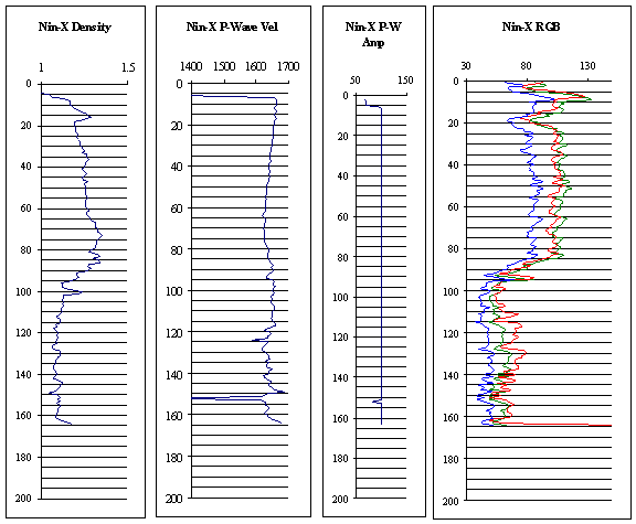
Core Analyzer Data (information about this to be provided later):
Soil Profile Image (Hi-resolution image available - 51 MB Tiff image):