Ninigret Pond Soil Pedon Description: S04-RI-009-004 (Site 2 – Mainland Slope, bouldery)
Quick Link:
Site Information
Pedon Description
Core Analyzer Data
Soil Profile Image
| Print Date: | 11/09/2004 | ||||||||||||||||||||||||||||||||||||||||||||||||||||
| Description Date: | 09/01/2004 | ||||||||||||||||||||||||||||||||||||||||||||||||||||
| Describer: | Mike Bradley, Jim Turenne | ||||||||||||||||||||||||||||||||||||||||||||||||||||
| Site ID: | Site 2 | ||||||||||||||||||||||||||||||||||||||||||||||||||||
| Site Notes: | Vibra core description. Core was analyzed/imaged by GSO using a Geo Tek Core Analyser, data available. | ||||||||||||||||||||||||||||||||||||||||||||||||||||
| Pedon ID: | S04-RI-009-004 | ||||||||||||||||||||||||||||||||||||||||||||||||||||
| Pedon Notes: | Soil consists of 10 cm of sandy marine deposits overlying a buried very poorly drained soil formed in loess over gravelly supraglacial till. | ||||||||||||||||||||||||||||||||||||||||||||||||||||
| Lab Source ID: | |||||||||||||||||||||||||||||||||||||||||||||||||||||
| Lab Pedon #: | Site 2 | ||||||||||||||||||||||||||||||||||||||||||||||||||||
|
|||||||||||||||||||||||||||||||||||||||||||||||||||||
| Pedon Type: | |||||||||||||||||||||||||||||||||||||||||||||||||||||
| Pedon Purpose: | Ninigret Pond subaqueous soil survey pilot project. | ||||||||||||||||||||||||||||||||||||||||||||||||||||
| Taxon Kind: | |||||||||||||||||||||||||||||||||||||||||||||||||||||
| Associated Soils: | |||||||||||||||||||||||||||||||||||||||||||||||||||||
| Location Information | |||||||||||||||||||||||||||||||||||||||||||||||||||||
| Country: | USA | ||||||||||||||||||||||||||||||||||||||||||||||||||||
| State: | RI | ||||||||||||||||||||||||||||||||||||||||||||||||||||
| County: | Washington | ||||||||||||||||||||||||||||||||||||||||||||||||||||
| MLRA: | 149B | ||||||||||||||||||||||||||||||||||||||||||||||||||||
| Soil Survey Area: | RI600-009 | ||||||||||||||||||||||||||||||||||||||||||||||||||||
| Quad Name: | Quonochataug | ||||||||||||||||||||||||||||||||||||||||||||||||||||
| Location Description: | Ninigret Pond, Charlestown, RI. Mud Cove - west basin, north. | ||||||||||||||||||||||||||||||||||||||||||||||||||||
| Legal Description: | |||||||||||||||||||||||||||||||||||||||||||||||||||||
| Latitude: | 41 degrees 21 minutes 36.57 seconds north | ||||||||||||||||||||||||||||||||||||||||||||||||||||
| Longitude: | 71 degrees 41 minutes 31.26 seconds west | ||||||||||||||||||||||||||||||||||||||||||||||||||||
| Datum: | NAD83 | ||||||||||||||||||||||||||||||||||||||||||||||||||||
| UTM Zone: | 19 | ||||||||||||||||||||||||||||||||||||||||||||||||||||
| UTM Easting: | 83933 meters | ||||||||||||||||||||||||||||||||||||||||||||||||||||
| UTM Northing: | 30761 meters | ||||||||||||||||||||||||||||||||||||||||||||||||||||
|
|||||||||||||||||||||||||||||||||||||||||||||||||||||
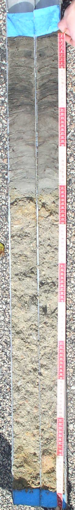
CA--0 to 10 centimeters (0.0 to 3.9 inches); olive gray (5Y 4/2) interior, loamy sand; massive; very friable, nonsticky, nonplastic; nonfluid; low penetration resistance; low excavation difficulty; negative reaction to alpha-alpha' dipyridyl; clear boundary.
Ab--10 to 21 centimeters (3.9 to 8.3 inches); very dark gray (5Y 3/1) interior, loamy sand; massive; very friable, nonsticky, nonplastic; nonfluid; low penetration resistance; low excavation difficulty; common fine roots throughout; negative reaction to alpha-alpha' dipyridyl; clear boundary.
Cg--21 to 41 centimeters (8.3 to 16.1 inches); 95 percent olive gray (5Y 5/2) interior, very fine sandy loam; massive; friable, nonsticky, nonplastic; nonfluid; low penetration resistance; low excavation difficulty; negative reaction to alpha-alpha' dipyridyl; 1 cm horizontal bands of A material mixing 5Y3/1; abrupt boundary.
2Cg1--41 to 68 centimeters (16.1 to 26.8 inches); 95 percent light brownish gray (2.5Y 6/2) interior, loamy coarse sand; single grain; moderate excavation difficulty; 5 percent coarse prominent irregular iron concretions with clear boundaries in matrix; 20 percent nonflat subangular indurated mixed rock fragments; clear boundary.
2Cg2--68 to 105 centimeters (26.8 to 41.3 inches); light brownish gray (2.5Y 6/2) interior, coarse sand; single grain; loose, nonsticky, nonplastic; nonfluid; moderate penetration resistance; moderate excavation difficulty; 40 percent nonflat subangular indurated 2- to 6-millimeter mixed rock fragments; negative reaction to alpha-alpha' dipyridyl; clear boundary.
2Cg3--105 to 120 centimeters (41.3 to 47.2 inches); 90 percent light yellowish brown (2.5Y 6/3) interior, coarse sand; single grain; loose, nonsticky, nonplastic; nonfluid; moderate penetration resistance; 10 percent coarse prominent irregular iron concretions with clear boundaries in matrix; 30 percent nonflat subangular indurated 2- to 6-millimeter mixed rock fragments; negative reaction to alpha-alpha' dipyridyl.
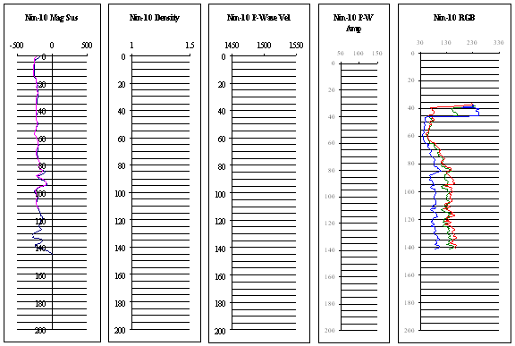
Core Analyzer Data (information about this to be provided later):
Soil Profile Image (Hi-resolution image available - 51 MB Tiff image):