Ninigret Pond Soil Pedon Description: VBB (Flood-Tidal Delta Slope)
Quick Links:
Site Information
Pedon Description
Map Unit Description
Lab
Data
Chemistry Data
Soil Profile Image
|
Print Date: |
06/15/2004 |
||||||||||||||||||||||||||||||||||||||||||||||||||||
|
Description Date: |
09/18/2000 |
||||||||||||||||||||||||||||||||||||||||||||||||||||
|
Describer: |
Mike Bradley |
||||||||||||||||||||||||||||||||||||||||||||||||||||
|
|
|||||||||||||||||||||||||||||||||||||||||||||||||||||
|
Site ID: |
VBB |
||||||||||||||||||||||||||||||||||||||||||||||||||||
|
Site Notes: |
Vibracore Description |
||||||||||||||||||||||||||||||||||||||||||||||||||||
|
Pedon ID: |
VBB |
||||||||||||||||||||||||||||||||||||||||||||||||||||
|
Pedon Notes: |
|
||||||||||||||||||||||||||||||||||||||||||||||||||||
|
Lab Source ID: |
URI |
||||||||||||||||||||||||||||||||||||||||||||||||||||
|
Lab Pedon #: |
|
||||||||||||||||||||||||||||||||||||||||||||||||||||
|
|
|||||||||||||||||||||||||||||||||||||||||||||||||||||
|
|||||||||||||||||||||||||||||||||||||||||||||||||||||
|
|
|||||||||||||||||||||||||||||||||||||||||||||||||||||
|
Pedon Type: |
|
||||||||||||||||||||||||||||||||||||||||||||||||||||
|
Pedon Purpose: |
research site – Masters Thesis |
||||||||||||||||||||||||||||||||||||||||||||||||||||
|
Taxon Kind: |
|
||||||||||||||||||||||||||||||||||||||||||||||||||||
|
Associated Soils: |
|
||||||||||||||||||||||||||||||||||||||||||||||||||||
|
|
|||||||||||||||||||||||||||||||||||||||||||||||||||||
|
Location Information |
|||||||||||||||||||||||||||||||||||||||||||||||||||||
|
Country: |
USA |
||||||||||||||||||||||||||||||||||||||||||||||||||||
|
State: |
RI |
||||||||||||||||||||||||||||||||||||||||||||||||||||
|
County: |
Washington |
||||||||||||||||||||||||||||||||||||||||||||||||||||
|
MLRA: |
149B |
||||||||||||||||||||||||||||||||||||||||||||||||||||
|
Soil Survey Area: |
|
||||||||||||||||||||||||||||||||||||||||||||||||||||
|
Quad Name: |
Quonochataug |
||||||||||||||||||||||||||||||||||||||||||||||||||||
|
|
|||||||||||||||||||||||||||||||||||||||||||||||||||||
|
Location Description: |
Ninigret Pond, Charlestown, RI |
||||||||||||||||||||||||||||||||||||||||||||||||||||
|
Legal Description: |
|
||||||||||||||||||||||||||||||||||||||||||||||||||||
|
|
|||||||||||||||||||||||||||||||||||||||||||||||||||||
|
Latitude: |
41 degrees 21 minutes 55.66 seconds north |
||||||||||||||||||||||||||||||||||||||||||||||||||||
|
Longitude: |
71 degrees 38 minutes 40.73 seconds west |
||||||||||||||||||||||||||||||||||||||||||||||||||||
|
Datum: |
NAD83 |
||||||||||||||||||||||||||||||||||||||||||||||||||||
|
UTM Zone: |
19 |
||||||||||||||||||||||||||||||||||||||||||||||||||||
|
UTM Easting: |
278804 meters |
||||||||||||||||||||||||||||||||||||||||||||||||||||
|
UTM Northing: |
4582703 meters |
||||||||||||||||||||||||||||||||||||||||||||||||||||
|
|
|||||||||||||||||||||||||||||||||||||||||||||||||||||
|
|||||||||||||||||||||||||||||||||||||||||||||||||||||
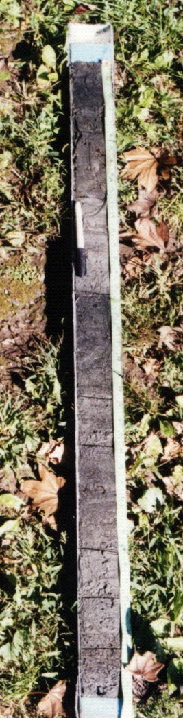
A1--0 to 13 centimeters; black (N 2.5/0), very fine sandy loam; abrupt.
A2--13 to 26 centimeters; very dark gray (5Y 3/1), very fine sandy loam; coarse distinct olive gray (5Y 4/2) mottles; abrupt.
C1--26 to 44 centimeters; very dark gray (5Y 3/1) and dark gray (5Y 4/1), sand; clear.
2Ab--44 to 62 centimeters; black (N 2.5/0), very fine sandy loam; abrupt.
2C1--62 to 69 centimeters; very dark gray (5Y 3/1), sandy loam; abrupt.
3Ab--69 to 86 centimeters; very dark gray (5Y 3/1), fine sandy loam; 1 percent shell fragments; abrupt.
3C1--86 to 93 centimeters; dark gray (5Y 4/1), loamy sand; abrupt.
3C2--93 to 100 centimeters; dark gray (5Y 4/1), loamy sand; abrupt.
4Ab--100 to 108 centimeters; very dark gray (5Y 3/1), sandy loam.
Map Unit Description (Bradley Stolt):
FtdS(A) – Flood-tidal Delta Slope, 1 – 2% slopes: These soils are found at the edge of the flood-tidal delta along the active and inactive lobes of the delta. Water depths are moderate (0.8 – 1.1 m). The subaqueous soils are highly stratified and buried ‘A’ horizons are very common. Surface and buried ‘A’ horizons are 9-30 cm thick and generally very dark olive gray, dark olive gray, and dark gray loams, silt loams, or fine sandy loams. ‘C’ horizon textures are sandy. Buried and subsurface horizons can have pH values of 8.5 or greater. Soils are classified as Typic Fluvaquents and Sodic Psammaquents, with inclusions of Sodic Endoaquents. Submerged topography is gently sloping toward deeper water. Eelgrass cover is high (>50%) and buried ‘A’ horizons are old eelgrass beds.
Field Descriptions:
|
Horizon |
Depth (cm) |
Boundary |
Field |
n-value |
Munsell |
Munsell |
Redox features |
Field |
Shell |
Notes |
|
|
lower |
Dist. |
Texture |
|
Color |
Color |
Color/Conc. |
Coarse |
Frags % |
*1 |
|
|
boundary |
|
Class |
|
(matrix) |
Name |
|
Frags % |
|
*2 |
|
A1 |
13 |
a |
vfsl |
> 1 |
N 2.5/ |
black |
|
|
|
|
|
A2 |
26 |
a |
vfsl |
> 1 |
5Y 3/1 |
very dark gray |
|
|
|
|
|
C1 |
44 |
c |
s |
|
5Y (3&4)/1 |
dark and very dark gray |
|
|
|
|
|
2Ab |
62 |
a |
vfsl |
> 1 |
N 2.5/ |
black |
|
|
|
|
|
2C1 |
69 |
a |
sl |
|
5Y 3/1 |
very dark gray |
|
|
|
|
|
3Ab |
86 |
a |
fsl |
|
5Y 3/1 |
very dark gray |
|
|
< 1% |
*3 |
|
3C1 |
93 |
a |
ls |
|
5Y 4/1 |
dark gray |
|
|
|
*4 |
|
3C2 |
100 |
a |
ls |
|
5Y 4/1 |
dark gray |
|
|
|
|
|
4Ab |
108 |
|
sl |
|
5Y 3/1 |
very dark gray |
|
|
|
*5 |
*1. Common med coarse eelgrass rhizomes and fragments
*2. Common distinct coarse mottles 5Y 4/2. Common med coarse eelgrass frags.
*3. Plant material. (Leaves probably old ee surface)
*4. Fine laminar OM lenses
*5. Salt marsh surface. Old Spartina leaves v. common. Very common medium and fine roots.
|
Horizon |
Depth (cm) |
% Coarse Frags |
% Shell Frags |
% VCO (1-2 mm) |
% CO (1-0.5 mm) |
% M (0.5-0.25 mm) |
% F (0.25-0.1 mm) |
% VF (0.1-0.05 mm) |
% Total Sand |
% Silt |
% Clay |
USDA Texture Class |
|
A1 |
13 |
0 |
0 |
8.2 |
54.8 |
0 |
0 |
0.1 |
37 |
54.8 |
8.2 |
sil |
|
A2 |
26 |
0 |
0 |
11 |
53 |
0.2 |
0.3 |
0.3 |
36 |
53 |
11 |
sil |
|
C1 |
44 |
0 |
0 |
1 |
9 |
0 |
0 |
0.6 |
90 |
9 |
1 |
vfs |
|
2Ab |
62 |
0.01 |
0.02 |
8.3 |
46.7 |
0.3 |
0.3 |
0 |
45 |
46.7 |
8.3 |
l |
|
2C |
69 |
0 |
0 |
2.3 |
32.7 |
1 |
1 |
1 |
65 |
32.7 |
2.3 |
vfsl |
|
3Ab |
86 |
0 |
0.01 |
9.3 |
50 |
0.1 |
0.1 |
0 |
40.7 |
50 |
9.3 |
l |
|
3C1 |
93 |
0 |
0 |
1 |
14.7 |
0.5 |
0.8 |
0.8 |
84.3 |
14.7 |
1 |
lvfs |
|
3C2 |
100 |
0 |
0 |
1 |
18 |
0.5 |
0.6 |
1 |
81 |
18 |
1 |
lvfs |
|
4Ab |
108 |
0 |
0 |
1.5 |
21.5 |
0.5 |
2.5 |
1.5 |
77 |
21.5 |
1.5 |
lvfs |
|
Horizon |
Depth (cm) |
Total Nitrogen (%) |
AVS (ug/g) |
CRS (ug/g) |
CaCO3 (%) |
Organic Carbon (%) |
|
A1 |
13 |
0.146 |
129 |
27 |
0.853 |
1.616 |
|
A2 |
26 |
0.161 |
NA |
NA |
0.852 |
2.020 |
|
C1 |
44 |
0.037 |
0 |
7.100 |
0.395 |
0.390 |
|
2Ab |
62 |
0.111 |
NA |
NA |
0.804 |
1.264 |
|
3Ab |
86 |
0.125 |
NA |
NA |
0.850 |
1.573 |
|
|
|