 USGS
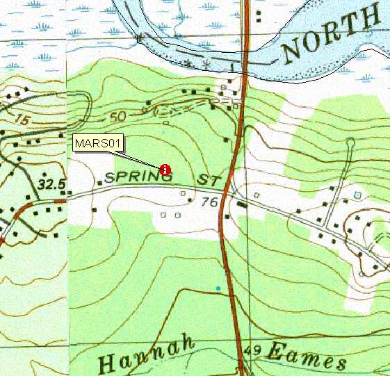
Topo Location
Download Monitoring Well locations for viewing with
Google Earth
USGS
Topo Location
Download Monitoring Well locations for viewing with
Google Earth| Soil Water Table Monitoring Index well MARS01-Scituate Soil, Marshfield MA. |
USGS
Topo Location
Download Monitoring Well locations for viewing with
Google Earth |
LOCATION.--Lat 42o09' 15" N, Lon 070o
44' 44"
W NAD 83. Massachusetts State Plane NAD 83, 262,345 Easting, 878,886 Northing.
Plymouth County, Town of Marshfield - 60 meters north of Spring St, 200 meters
west of Route 3A, Audubon Conservation Land. Location geo-referenced with a PLGR GPS.
WELL CHARACTERISTICS.--Well type - 2.0 inch diameter screened PVC pipe, total well depth = 62 inches below the surface. Installed October 11, 2001.
ELEVATION.-- Surface is 25 Meters (85 feet) above sea level, from topographic map (National Geodetic Vertical Datum of 1929).
SOIL TYPE.--Scituate Series - moderately well drained soil formed dense basal till. Click for a complete pedon description of the soil log from the MARS01 well. The estimated average seasonal high water table, based on soil morphology for this site is 19 inches below the surface based on soil morphology.
GEOLOGY.-- Sandy loam eolian mantle underlain by lodgement till.
WELL OBSERVATIONS.--Mars01 well has the highest water table at -8.0 inches below the surface on April 1 2003. Notes: Water table depth is the measured depth (inches) to water below the ground surface. Ground surface datum for these readings is 0, to determine the actual depth to water below the surface elevation subtract the depth in the table from 85 feet. The 62 inch depth is the total depth of the well.
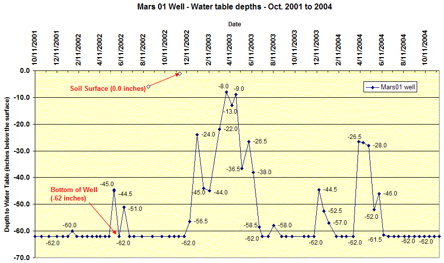
Hydrograph of Mars01 well for the record period 10-01 to 9-03. The graph
shows the effect of a drought year (Fall 2001 - Winter 2002) with the being
mostly dry. Winter/spring of 2003 has has normal precipitation and the well is
showing normal water table ranges for the soil type.
Contact Jim Turenne for more information | Return to Index Wells
Click here to view a presentation about using a
device to measure maximum water table depths (Morgan and Stolt)
USGS Water Resources of
Massachusetts and Rhode Island - Ground-Water Data
WRP Technical Note HY-IA-3.1 Installing Monitoring
Wells/Piezometers in Wetlands