Soil Water Table Monitoring Index well SCIT01 - Woodbridge Soils
Topo Map location of well (Cohasett Quad), click for larger image.
1969 Soil Survey map of well SCIT01, this older soil map has the area
delineated EuB - Essex extremely stony coarse sandy loam, 3 to 8 percent slopes.
Essex soils are well drained till soils. The updated mapping below mapped
the area moderately well drained. Click for
map unit legend for this map.
Updated
soil map of SCIT01 well (ADVANCE COPY, SUBJECT TO CHANGE). The area around
the well is mapped 311A-Woodbridge fine sandy loam, 0 to 3 percent slopes,
very stony. Click for a description of
this soil.
Download Monitoring Well
locations for viewing with Google Earth
LOCATION.--Lat 42o12'32" N, Long 070o28'52"
W (Mass. State Plane NAD 83 - 259,350 Easting, 884,532 Northing.
Plymouth County, Town of Scituate - East of Route 3A, North of Main Lot Road,
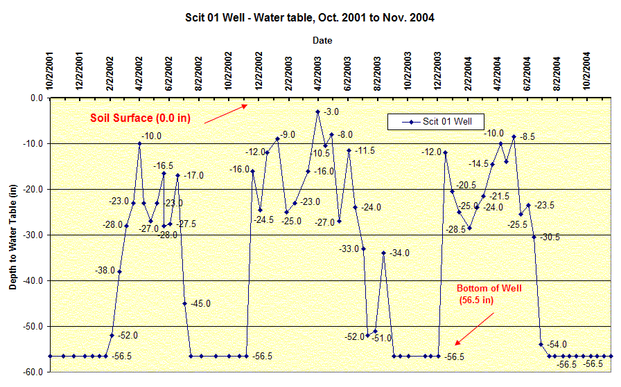
Scituate Conservation Land. Location geo-referenced with a PLGR GPS. WELL CHARACTERISTICS.--Small hand-dug pit to 45 inches, mechanical drill
hole to 56.5 inches. Well type - 2.0 inch diameter screened PVC pipe, total well
depth = 56.5 inches below the surface. Installed September 18, 2001. ELEVATION.-- Surface is 165 ft above sea level, from topographic map
(National Geodetic Vertical Datum of 1929). SOIL TYPE.--Woodbridge Series - moderately well drained soil formed in
dense basal till. Click for a complete
pedon description of the soil log from the SCIT01 well. The estimated average seasonal high water table,
based on soil morphology for this site is 24 inches below the surface based on
soil morphology. GEOLOGY.-- Lodgement till, mixed minerology. WELL OBSERVATIONS.--Highest recorded watertable - 3 inches below the surface. Notes: WT_Depth is the measured depth (inches) to water below the ground
surface. Ground surface datum for these readings is 0, to determine the actual
depth to water below the surface elevation subtract the depth in the table
from 165 feet. The 56.5 inch depth is the total
depth of the well.
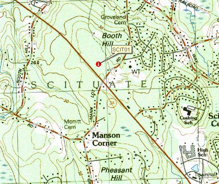 Topo Map location of well (Cohasett Quad), click for larger image.
 1969 Soil Survey map of well SCIT01, this older soil map has the area
delineated EuB - Essex extremely stony coarse sandy loam, 3 to 8 percent slopes.
Essex soils are well drained till soils. The updated mapping below mapped
the area moderately well drained. Click for
map unit legend for this map.
1969 Soil Survey map of well SCIT01, this older soil map has the area
delineated EuB - Essex extremely stony coarse sandy loam, 3 to 8 percent slopes.
Essex soils are well drained till soils. The updated mapping below mapped
the area moderately well drained. Click for
map unit legend for this map. Updated
soil map of SCIT01 well (ADVANCE COPY, SUBJECT TO CHANGE). The area around
the well is mapped 311A-Woodbridge fine sandy loam, 0 to 3 percent slopes,
very stony. Click for a description of
this soil.
Updated
soil map of SCIT01 well (ADVANCE COPY, SUBJECT TO CHANGE). The area around
the well is mapped 311A-Woodbridge fine sandy loam, 0 to 3 percent slopes,
very stony. Click for a description of
this soil.