Soil Water Table Monitoring Index well SCIT02 - Newfields Soils
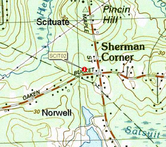
Topo Map location of well (Cohasett Quad), click for larger image.
1969 Soil Survey map of well SCIT02, this older soil map has the area
delineated GeB - Gloucester extremely stony loamy sand, 3 to 15 percent slopes.
The updated mapping has the area mapped
moderately well drained Newfields soils. Click for
map unit legend for this map.
Updated
soil map of SCIT02 well (ADVANCE COPY, SUBJECT TO CHANGE). The area around
the well is mapped 427A-Newfields fine sandy loam, 0 to 3 percent slopes,
very stony. Click for a description of
this soil.
Download Monitoring Well
locations for viewing with Google Earth
LOCATION.--Lat 42o11' 04" N, Long 070o
46' 44"
W NAD 83. Massachusetts State Plane NAD 83, 259,556 Easting, 881,835 Northing.
Plymouth County, Town of Scituate - Sherman Corner, 40 meters North of Old Oaken
Bucket, 110 meters West of Maple St. Scituate Conservation Land. Location geo-referenced with a PLGR GPS. WELL CHARACTERISTICS.--Small hand-dug pit to 35 inches, mechanical drill
hole to 65 inches. Well type - 2.0 inch diameter screened PVC pipe, total well
depth = 65 inches below the surface. Installed October 2, 2001. ELEVATION.-- Surface is 25 Meters (82 feet) above sea level, from topographic map
(National Geodetic Vertical Datum of 1929). SOIL TYPE.--Newfields Series - moderately well drained soil formed in
ice contact deposits. Click for a complete pedon description of the soil log from the SCIT02 well. The estimated average seasonal high water table,
based on soil morphology for this site is 27 inches below the surface based on
soil morphology. GEOLOGY.-- Ice contact deposits (Supraglacial till with a sandy loam
eolian mantle). WELL OBSERVATIONS.--Highest recorded water table is-4 inches below the surface
on April 02, 2002. Hydrograph Notes: WT_Depth is the measured depth (inches) to water below the ground
surface. Ground surface datum for these readings is 0, to determine the actual
depth to water below the surface elevation subtract the depth in the table
from 82 feet. The 65 inch depth is the total
depth of the well.
 Topo Map location of well (Cohasett Quad), click for larger image.
 1969 Soil Survey map of well SCIT02, this older soil map has the area
delineated GeB - Gloucester extremely stony loamy sand, 3 to 15 percent slopes.
The updated mapping has the area mapped
moderately well drained Newfields soils. Click for
map unit legend for this map.
1969 Soil Survey map of well SCIT02, this older soil map has the area
delineated GeB - Gloucester extremely stony loamy sand, 3 to 15 percent slopes.
The updated mapping has the area mapped
moderately well drained Newfields soils. Click for
map unit legend for this map.