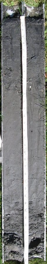
(tape in inches)
RI009-2006-008-WH
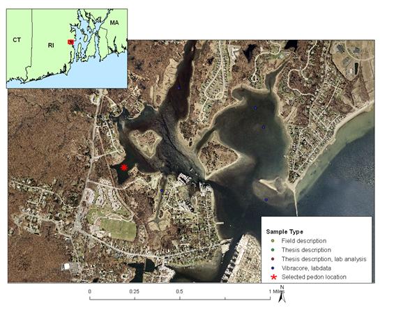
Mainland Cove; Wickford Harbor, North Kingstown, RI
Links:
The Fort Neck series consist of very deep, subaqueous soils in low energy coastal lagoons and channels. The Fort Neck soils are formed in less than 100 cm marine silts over marine sands or stratified sand and gravel. Slope ranges from 0 to 5 percent.
A1--0 to 1 centimeters; black (N 2.5/0) interior, silt loam; very fluid; very abrupt smooth boundary.
A2--1 to 10 centimeters; greenish black (10Y 2.5/1) interior, silt loam; very fluid; clear smooth boundary.
AC--10 to 26 centimeters; very dark gray (5Y 3/1) interior, silt
loam; moderately fluid; 1 percent shell fragments; Medium and fine shell
fragments
; abrupt smooth boundary.
C1--26 to 65 centimeters; dark greenish gray (10Y 3/1) interior, silt loam; moderately fluid; abrupt smooth boundary.
C2--64 to 74 centimeters; dark greenish gray (10Y 3/1) interior, sandy loam; slightly fluid; abrupt smooth boundary.
2C1--74 to 88 centimeters; greenish black (10Y 2.5/1) interior, coarse sand gravel; nonfluid; 20 percent nonflat rounded mixed rock fragments.

|
|
|
|
General Description: |
26 cm marine silts over loess and glacial outwash |
|
Location Description: |
State of Rhode Island, Washington County, Town of North Kingstown – Wickford Harbor, |
|
Location Map: |
|
|
Description Date: |
9/12/06 |
|
Describer: |
J. Turenne, M. Payne |
|
Pedon ID: |
RI009-2006-008-WH |
|
Pedon Notes: |
3 inch vibracore collected on 8/31/2006; split and described 9/12/2006. |
|
Lab Source ID: |
URI |
|
Lab Pedon #: |
core #3, 369 |
|
Soil Name as Described/Sampled: |
Mainland Cove |
|
Soil Name as Correlated: |
Fort Neck |
|
Classification(10th edition): |
Coarse-silty over sandy or sandy-skeletal, mesic Haplic Sulfaquents |
|
Classification (Wassents): |
Coarse-silty over sandy or sandy-skeletal, mesic Haplic Sulfiwassents |
|
Water Depth (feet): |
|
|
Primary Earth Cover: |
water cover |
|
Existing Vegetation: |
none |
|
Parent Material: |
silty marine deposits and/or sandy outwash |
|
Particle Size Control Section: |
25 to 100 cm. |
|
Diagnostic Features: |
Sulfidic materials 0-74 cm; Reduced matrix 0-88 cm |
|
|
|
|
Location Information |
|
|
Country: |
United States |
|
State: |
Rhode Island |
|
County: |
WASHINGTON |
|
MLRA: |
144A -- New England and Eastern New York Upland, Southern Part |
|
Soil Survey Area: |
RI600 -- State of Rhode Island: Bristol, Kent, Newport, Providence, and Washington Counties |
|
Quad Name: |
Wickford |
|
Latitude: |
41 degrees 34 minutes 43.129 seconds north |
|
Longitude: |
71 degrees 27 minutes 23.328 seconds east |
|
Datum: |
NAD83 |
|
UTM Zone: |
19 |
|
UTM Easting: |
295216 meters |
|
UTM Northing: |
4605910 meters |
|
Physiographic Division: |
Appalachian Highlands |
|
Physiographic Province: |
New England Province |
|
Physiographic Section: |
Seaboard lowland section |
|
State Physiographic Area: |
|
|
Local Physiographic Area: |
Wickford Harbor |