RI009-2006-009-WH
Mainland Shoreface; Wickford Harbor, North Kingstown, RI
Links:
Cg--0 to 21 centimeters; dark gray (5Y 4/1) interior fine sand; 93 percent sand; 7 percent silt; single grain; loose; nonfluid; 3 percent nonflat subrounded mixed rock fragments; electrical conductivity of 23.2 mmhos/cm by ec meter, saturated paste; neutral, pH 7.3, pH meter 1:1 water; rock fragments are at the bottom of the horizon; very abrupt smooth boundary.
Ab--21 to 36 centimeters; very dark grayish brown (10YR 3/2) interior sand; 85 percent sand; 15 percent silt; massive; loose; nonfluid; electrical conductivity of 35.8 mmhos/cm by ec meter, saturated paste; neutral, pH 7.0, pH meter 1:1 water; many fine to medium plant fragments; gradual wavy boundary.
2Cg1--36 to 60 centimeters; dark gray (5Y 4/1) interior fine sandy loam; 67 percent sand; 33 percent silt; massive; very friable; nonfluid; electrical conductivity of 12.5 mmhos/cm by ec meter, saturated paste; neutral, pH 7.3, pH meter 1:1 water; medium plant fragments; gradual smooth boundary.
2Cg2--60 to 78 centimeters; dark greenish gray (10Y 4/1) silt loam; 49 percent sand; 51 percent silt; massive; very friable; nonfluid; 5 percent nonflat rounded mixed rock fragments; electrical conductivity of 8.9 mmhos/cm by ec meter, saturated paste; slightly alkaline, pH 7.4, pH meter 1:1 water; clear smooth boundary.
3Cg3--78 to 120 centimeters; dark gray (N 4/0) silt loam; 45 percent sand; 55 percent silt; massive; very friable; nonfluid; electrical conductivity of 7.8 mmhos/cm by ec meter, saturated paste; slightly alkaline, pH 7.7, pH meter 1:1 water.

|
|
|
|
General Description: |
50 cm marine sands over marine silts |
|
Location Description: |
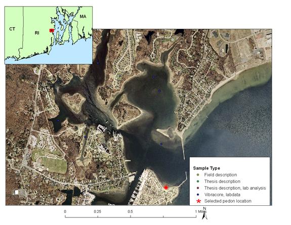
State of Rhode Island, Washington County, Town of North Kingstown – Wickford Harbor, |
|
Location Map: |
|
|
Description Date: |
9/12/06 |
|
Describer: |
J. Turenne, M. Payne |
|
Pedon ID: |
RI009-2006-009-WH |
|
Pedon Notes: |
3 inch vibracore collected on 8/31/2006; split and described 9/12/2006. |
|
Lab Source ID: |
URI |
|
Lab Pedon #: |
core #4, 254 |
|
Soil Name as Described/Sampled: |
Mainland Shoreface |
|
Soil Name as Correlated: |
Rhodesfolly |
|
Classification(10th edition): |
Coarse-loamy, mesic Haplic Sulfaquents |
|
Classification (Wassents): |
Coarse-loamy, mesic Sulfic Fluviwassents |
|
Water Depth (feet): |
|
|
Primary Earth Cover: |
water cover |
|
Existing Vegetation: |
none |
|
Parent Material: |
Sandy marine deposits |
|
Particle Size Control Section: |
25 to 100 cm. |
|
Diagnostic Features: |
aquic conditions 0 to 120 cm. |
| reduced matrix 0 to 120 cm. | |
| sulfidic materials 36 to 60 cm. | |
| lithologic discontinuity 36 to 78 cm. | |
| sulfidic materials 78 to 120 cm. | |
|
|
lithologic discontinuity 78 to
120 cm.
|
|
Location Information |
|
|
Country: |
United States |
|
State: |
Rhode Island |
|
County: |
WASHINGTON |
|
MLRA: |
144A -- New England and Eastern New York Upland, Southern Part |
|
Soil Survey Area: |
RI600 -- State of Rhode Island: Bristol, Kent, Newport, Providence, and Washington Counties |
|
Quad Name: |
Wickford |
|
Latitude: |
41 degrees 34 minutes 16.399 seconds north |
|
Longitude: |
71 degrees 26 minutes 26.185 seconds east |
|
Datum: |
NAD83 |
|
UTM Zone: |
19 |
|
UTM Easting: |
296516 meters |
|
UTM Northing: |
4605048 meters |
|
Physiographic Division: |
Appalachian Highlands |
|
Physiographic Province: |
New England Province |
|
Physiographic Section: |
Seaboard lowland section |
|
State Physiographic Area: |
|
|
Local Physiographic Area: |
Wickford Harbor |