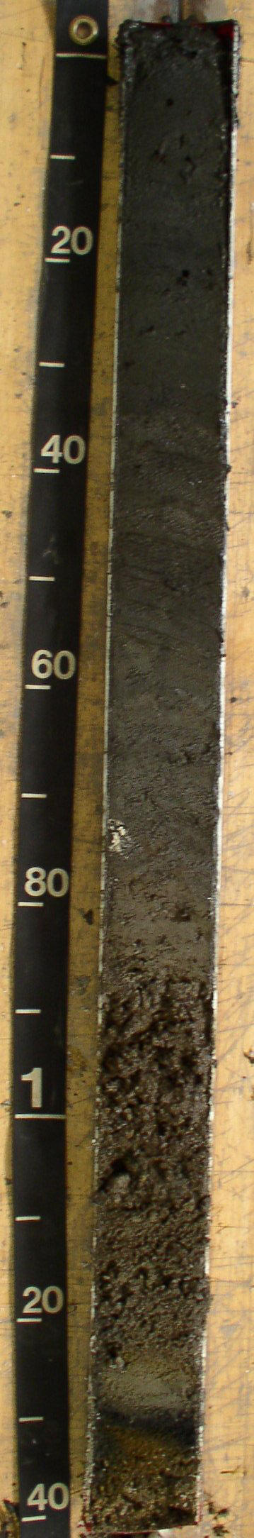
(tape in cm)
S05-RI-009-012A / RI009-2005-012A-NP
Shallow Lagoon Bottom; Ninigret Pond, Charlestown, RI
Links:
The Fort Neck series consist of very deep, subaqueous soils in low energy coastal lagoons and channels. The Fort Neck soils are formed in less than 100 cm marine silts over marine sands or stratified sand and gravel. Slope ranges from 0 to 5 percent.
Ag--0 to 9 centimeters; black (5Y 2.5/1) interior, silt; 7 percent sand; 92 percent silt; 1 percent clay; massive; very friable, noncemented, slightly sticky, nonplastic; very fluid; low toughness; extremely low penetration resistance; low excavation difficulty; common very fine roots throughout; 1 percent flat angular shell fragments; negative reaction to alpha-alpha' dipyridyl; electrical conductivity of 39 mmhos/cm by ec meter, saturated paste; moderately alkaline, pH 7.9, pH meter, saturated paste; clear; Lab sample # 17.
CAg--9 to 34 centimeters; 60 percent very dark gray (5Y 3/1) interior and 40 percent black (5Y 2.5/1) interior, silt loam, gray (5Y 6/1) interior, dry; 9 percent sand; 67 percent silt; 25 percent clay; massive; very friable, very hard, slightly sticky, nonplastic; slightly fluid; low excavation difficulty; negative reaction to alpha-alpha' dipyridyl; electrical conductivity of 34 mmhos/cm by ec meter, saturated paste; moderately alkaline, pH 8, pH meter, saturated paste; Vertical oriented reed plant fragments observed, interpreted as eelgrass.; abrupt; Lab sample # 18.
Cg1--34 to 62 centimeters; very dark gray (5Y 3/1) interior, very fine sandy loam, gray (5Y 6/1) interior, dry; 60 percent sand; 23 percent silt; 17 percent clay; massive; very friable, very hard, nonsticky, nonplastic; slightly fluid; low toughness; very low penetration resistance; low excavation difficulty; 1 percent flat angular shell fragments; negative reaction to alpha-alpha' dipyridyl; electrical conductivity of 33 mmhos/cm by ec meter, saturated paste; moderately alkaline, pH 8, pH meter, saturated paste; Very thin algal filaments observed.; abrupt; Lab sample # 19.
Cg2--62 to 78 centimeters; loamy fine sand; 88 percent sand; 10 percent silt; 2 percent clay; massive; very friable, nonsticky, nonplastic; nonfluid; low toughness; low penetration resistance; low excavation difficulty; 1 percent coarse prominent irregular iron-manganese masses with sharp boundaries in matrix and 1 percent fine and medium distinct irregular iron depletions with sharp boundaries infused into matrix adjacent to pores; 1 percent nonflat subangular granite fragments; negative reaction to alpha-alpha' dipyridyl; electrical conductivity of 25 mmhos/cm by ec meter, saturated paste; neutral, pH 7, pH meter, saturated paste; abrupt; Lab sample # 20.
2Cg3--78 to 85 centimeters; olive gray (5Y 4/2) interior, gravelly coarse sandy loam, light gray (5Y 7/1) interior, dry; 64 percent sand; 33 percent silt; 3 percent clay; massive; friable, very hard, nonsticky, nonplastic; nonfluid; 23 percent nonflat subrounded granite fragments; positive reaction to alpha-alpha' dipyridyl; electrical conductivity of 21 mmhos/cm by ec meter, saturated paste; slightly alkaline, pH 7.4, pH meter, saturated paste; At boundary with Cg2 identified 5 percent marsh plant fragments. Horizon showed a negative reaction to alpha-alpha when moist but a positive reaction was observed when (tape in cm) dried.; abrupt; Lab sample # 21.
3CA1--85 to 103 centimeters; very dark grayish brown (2.5Y 3/2) interior, very gravelly coarse sandy loam; single grain; loose, nonsticky, nonplastic; nonfluid; 53 percent nonflat subrounded granite fragments; electrical conductivity of 20 mmhos/cm by ec meter, saturated paste; slightly alkaline, pH 7.8, pH meter, saturated paste; Plant fragments (thin hairs) origin unknown.; clear; Lab sample # 22.
3C1--103 to 121 centimeters; olive gray (5Y 4/2) interior, stratified very gravelly coarse sandy loam, gray (2.5Y 6/1) interior, dry; 74 percent sand; 24 percent silt; 2 percent clay; single grain; loose, nonsticky, nonplastic; nonfluid; 60 percent nonflat subrounded granite fragments; electrical conductivity of 11 mmhos/cm by ec meter, saturated paste; moderately alkaline, pH 7.9, pH meter, saturated paste; abrupt; Lab sample # 23.
4C1--121 to 133 centimeters; coarse sand; 91 percent sand; 7 percent silt; 2 percent clay; single grain; electrical conductivity of 13 mmhos/cm by ec meter, saturated paste; moderately alkaline, pH 8, pH meter, saturated paste; Varigated color patterns, unsure of origin: 1 cm 2.5Y5/4 then 4 cm 2.5Y 5/2, 1 cm N 2/0 then 10YR 4/6 - see photo.; abrupt; Lab sample # 26.
4C2--133 to 138 centimeters; olive brown (2.5Y 4/3) interior, stratified very gravelly coarse sand; 97 percent sand; 3 percent silt; 0 percent clay; single grain; loose, nonsticky, nonplastic; nonfluid; 35 percent nonflat subrounded granite fragments; electrical conductivity of 19 mmhos/cm by ec meter, saturated paste; moderately alkaline, pH 8.1, pH meter, saturated paste; Lab sample # 27.

|
|
|
|
General Description: |
Deep marine sands with multiple buried surface horizons |
|
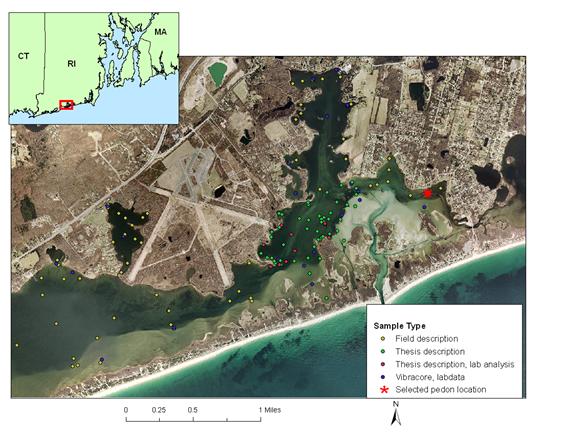
Location Description: |
Ninigret Pond, Charleston, RI - East basin, SW of Allen's cove. 300 Feet south of Arches Road, 875 feet west of Pond Street. |
|
Location Map: |
|
|
Description Date: |
10/20/2005 |
|
Describer: |
J. Turenne, M. Bradley, M. Stolt |
|
Pedon ID: |
S05-RI-009-012A |
|
Pedon Notes: |
4" diameter PVC core taken with Rossfelder Vibracore (GSO), Lab analysis being conducted by URI Soil Dept, core has been imaged by GSO using a geotek core analyzer. Samples were air dired and dry color, rupture resistance and reaction to alpha-alpha was recorded. |
|
Lab Source ID: |
URI |
|
Lab Pedon #: |
|
|
Soil Name as Described/Sampled: |
Shallow Lagoon Bottom |
|
Soil Name as Correlated: |
Fort Neck |
|
Classification(10th edition): |
Fine-loamy over sandy or sandy-skeletal, mixed, nonacid Typic Sulfaquents |
|
Classification (Wassents): |
Fine-loamy over sandy or sandy-skeletal, mixed, nonacid Typic Sulfiwassents |
|
Water Depth (feet): |
-3 |
|
Primary Earth Cover: |
water cover |
|
Existing Vegetation: |
none |
|
Parent Material: |
silty estuarine deposits derived from mixed over silty eolian deposits derived from igneous, metamorphic and sedimentary rock over gravelly glaciofluvial deposits derived from igneous, metamorphic and sedimentary rock |
|
Particle Size Control Section: |
25 to 100 cm. |
|
Diagnostic Features: |
Reduced matrix 0-173 cm |
|
|
|
|
Location Information |
|
|
Country: |
United States |
|
State: |
Rhode Island |
|
County: |
WASHINGTON |
|
MLRA: |
149B -- Long Island-Cape Cod Coastal Lowland |
|
Soil Survey Area: |
RI600 -- State of Rhode Island: Bristol, Kent, Newport, Providence, and Washington Counties |
|
Quad Name: |
Quonochontaug, Rhode Island |
|
Latitude: |
41 degrees 22 minutes 4.00 seconds north |
|
Longitude: |
71 degrees 37 minutes 56.00 seconds west |
|
Datum: |
NAD83 |
|
UTM Zone: |
19 |
|
UTM Easting: |
279837 meters |
|
UTM Northing: |
4582934 meters |
|
Physiographic Division: |
Atlantic Lowland |
|
Physiographic Province: |
Coastal Plain |
|
Physiographic Section: |
Embayed section |
|
State Physiographic Area: |
|
|
Local Physiographic Area: |
Ninigret Pond |