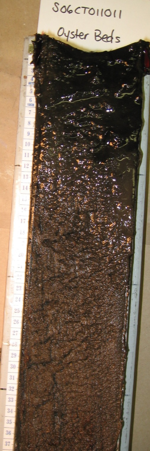
(tape in cm)
S06CT011011
Fluviomarine Bottom, Little Narragansett Bay, Pawcatuck, CT
Links:
Ag--0 to 10 centimeters; black (N 2.5/0) reduced mucky silt loam; massive; friable, nonsticky, nonplastic; very fluid; common fine roots throughout; neutral, pH 6.7, pH meter 1:1 water smooth boundary.
Cg1--10 to 20 centimeters; black (N 2.5/0) reduced mucky silt loam; massive; friable, nonsticky, nonplastic; slightly fluid; common fine roots throughout; slightly alkaline, pH 7.5, pH meter 1:1 water smooth boundary.
Cg2--20 to 48 centimeters; black (2.5Y 2.5/1) reduced mucky silt loam; massive; friable, nonsticky, nonplastic; slightly fluid; common fine roots throughout; common fine low-continuity irregular pores; moderately alkaline, pH 8.0, pH meter 1:1 water smooth boundary.
2Cg1--48 to 78 centimeters; black (2.5Y 2.5/1) reduced coarse sand; massive; friable, nonsticky, nonplastic; nonfluid; common fine roots throughout; common fine low-continuity irregular pores; neutral, pH 6.9, pH meter 1:1 water smooth boundary. Lab sample #
2Cg2--78 to 85 centimeters; black (2.5Y 2.5/1) reduced loamy coarse sand; massive; friable, nonsticky, nonplastic; slightly fluid; common fine roots throughout; common fine low-continuity irregular pores; neutral, pH 6.7, pH meter 1:1 water smooth boundary.
3Cg1--85 to 95 centimeters; black (2.5Y 2.5/1) reduced loamy sand; single grain; loose, nonsticky, nonplastic; nonfluid; 5 percent nonflat subrounded 2- to 76-millimeter mixed rock fragments; neutral, pH 6.7, pH meter 1:1 water irregular boundary.
3Cg2--95 to 106 centimeters; 60 percent dark grayish brown (2.5Y 4/2) reduced and 40 percent gray (2.5Y 5/1) reduced silt loam; massive; friable, nonsticky, nonplastic; nonfluid; common fine low- continuity irregular pores; neutral, pH 6.9, pH meter 1:1 water smooth boundary.
3Cg3--106 to 113 centimeters; gray (2.5Y 5/1) reduced silt loam; massive; friable, nonsticky, nonplastic; nonfluid; common fine low-continuity irregular pores; neutral, pH 7.1, pH meter 1:1 water.
| S06CT011011_LNB | NSSL | ||||||||
| Horizon | Depth (cm) | pH | %C | %N | %S | Ca | Mg | Na | K |
| A | 0-10 | 5.5 | 9.18 | 0.81 | 2.62 | 17.3 | 26.1 | 99.5 | 4.8 |
| C1 | 10-20 | 6 | 1.19 | 0.05 | 0.70 | 3.0 | 13.5 | 32.7 | 2.9 |
| C2 | 20-50 | 7.2 | 0.78 | 0.04 | 0.21 | 1.8 | 7.3 | 22.5 | 3.3 |
| C3 | 50-78 | 5.2 | 1.72 | 0.10 | 1.49 | 1.4 | 3.7 | 10.6 | 0.1 |
| C4 | 78-85 | 5.4 | 2.93 | 0.22 | 2.14 | 4.4 | 9.9 | 29.8 | 0.9 |
| C5 | 85-95 | 5.2 | 9.33 | 0.67 | 5.20 | 9.9 | 22.9 | 75.2 | 2.3 |
| 2Cg1 | 95-106 | 5.5 | 10.85 | 0.89 | 3.04 | 16.8 | 39.3 | 119.4 | 4.9 |
| 2Cg2 | 106-113 | 5.8 | 8.9 | 0.777 | 2.74 | 14 | 31.1 | 93.5 | 4.6 |
| Horizon | %VCS | %CS | %MS | %FS | %VFS | %Sand | %Silt | %Clay | Texture |
| A | 0.5 | 0.7 | 1.3 | 2.0 | 4.9 | 9 | 65 | 26 | silt loam |
| C1 | 0.9 | 3.4 | 5.0 | 4.7 | 6.7 | 21 | 57 | 22 | silt loam |
| C2 | 0.3 | 1.0 | 1.6 | 3.2 | 6.4 | 13 | 72 | 15 | silt loam |
| C3 | 6.8 | 21.0 | 38.1 | 18.5 | 4.0 | 88 | 8 | 4 | coarse sand |
| C4 | 7.9 | 26.3 | 28.7 | 15.6 | 3.5 | 82 | 12 | 6 | loamy coarse sand |
| C5 | 1.0 | 7.9 | 11.9 | 10.9 | 6.0 | 38 | 40 | 22 | loam |
| 2Cg1 | 0.1 | 0.7 | 2.0 | 3.5 | 4.6 | 11 | 60 | 29 | silty clay loam |
| 2Cg2 | nd | 0.3 | 0.9 | 2.2 | 5.7 | 9 | 66 | 25 | silt loam |
|
|
|
|
General Description: |
48 cm fluid silt loam over sands |
|
Location Description: |
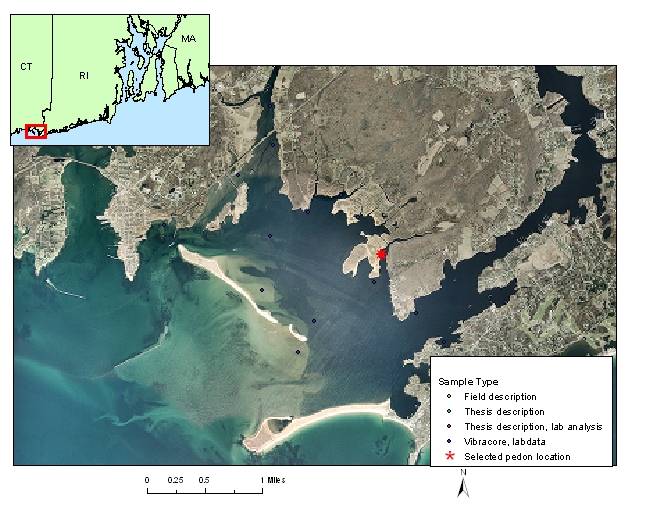
State of Connecticut, Pawcatuck, Little Narragansett Bay, submerged stream valley near marsh |
|
Location Map: |
|
|
Description Date: |
9/8/2006 |
|
Describer: |
D. Surabian, D. Parizek, M. Payne |
|
Pedon ID: |
06CT011011 |
|
Pedon Notes: |
4 inch vibracore |
|
Lab Source ID: |
NSSL |
|
Lab Pedon #: |
|
|
Soil Name as Described/Sampled: |
Fluviomarine bottom |
|
Soil Name as Correlated: |
Wamphassuc |
|
Classification(10th edition): |
Coarse-loamy over sandy or sandy-skeletal, mixed, nonacid, mesic Haplic Sulfaquents |
|
Classification (Wassents): |
Coarse-loamy over sandy or sandy-skeletal, mixed, nonacid, mesic Haplic Sulfiwassents |
|
Water Depth (feet): |
|
|
Primary Earth Cover: |
water cover |
|
Existing Vegetation: |
Other grass/herbaceous cover |
|
Parent Material: |
silty marine deposits over sand |
|
Particle Size Control Section: |
25 to 100 cm. |
|
Diagnostic Features: |
aquic conditions 0 to 113 cm; reduced matrix 0 to 113 cm; sulfidic materials 48 to 85 cm; lithologic discontinuity 48 to 85 cm; lithologic discontinuity 85 to 113 cm. |
|
|
|
|
Location Information |
|
|
Country: |
United States |
|
State: |
Connecticut |
|
County: |
NEW LONDON |
|
MLRA: |
144A -- New England and Eastern New York Upland, Southern Part |
|
Soil Survey Area: |
CT600 -- State of Connecticut |
|
Quad Name: |
Watch Hill, Connecticut |
|
Latitude: |
41 degrees 19 minutes 50.9 seconds north |
|
Longitude: |
71 degrees 51 minutes 48.9 seconds west |
|
Datum: |
NAD83 |
|
UTM Zone: |
19T |
|
UTM Easting: |
260362.67 meters |
|
UTM Northing: |
4579435.89 meters |
|
Physiographic Division: |
Atlantic Lowland |
|
Physiographic Province: |
Coastal Plain |
|
Physiographic Section: |
Seaboard lowland section |
|
State Physiographic Area: |
|
|
Local Physiographic Area: |
Little Narragansett Bay |