|
Print Date: |
06/15/2004 |
||||||||||||||||||||||||||||||||||||||||||||||||||||
|
Description Date: |
09/13/2000 |
||||||||||||||||||||||||||||||||||||||||||||||||||||
|
Describer: |
Mike Bradley |
||||||||||||||||||||||||||||||||||||||||||||||||||||
|
|
|||||||||||||||||||||||||||||||||||||||||||||||||||||
|
Site ID: |
Ninigret057 |
||||||||||||||||||||||||||||||||||||||||||||||||||||
|
Site Notes: |
Bucket Auger |
||||||||||||||||||||||||||||||||||||||||||||||||||||
|
Pedon ID: |
Ninigret057 |
||||||||||||||||||||||||||||||||||||||||||||||||||||
|
Pedon Notes: |
|
||||||||||||||||||||||||||||||||||||||||||||||||||||
|
Lab Source ID: |
URI |
||||||||||||||||||||||||||||||||||||||||||||||||||||
|
Lab Pedon #: |
|
||||||||||||||||||||||||||||||||||||||||||||||||||||
|
|
|||||||||||||||||||||||||||||||||||||||||||||||||||||
|
|||||||||||||||||||||||||||||||||||||||||||||||||||||
|
|
|||||||||||||||||||||||||||||||||||||||||||||||||||||
|
Pedon Type: |
|
||||||||||||||||||||||||||||||||||||||||||||||||||||
|
Pedon Purpose: |
Research – Masters Thesis |
||||||||||||||||||||||||||||||||||||||||||||||||||||
|
Taxon Kind: |
|
||||||||||||||||||||||||||||||||||||||||||||||||||||
|
Associated Soils: |
|
||||||||||||||||||||||||||||||||||||||||||||||||||||
|
|
|||||||||||||||||||||||||||||||||||||||||||||||||||||
|
Location Information |
|||||||||||||||||||||||||||||||||||||||||||||||||||||
|
Country: |
USA |
||||||||||||||||||||||||||||||||||||||||||||||||||||
|
State: |
RI |
||||||||||||||||||||||||||||||||||||||||||||||||||||
|
County: |
Washington |
||||||||||||||||||||||||||||||||||||||||||||||||||||
|
MLRA: |
149B |
||||||||||||||||||||||||||||||||||||||||||||||||||||
|
Soil Survey Area: |
|
||||||||||||||||||||||||||||||||||||||||||||||||||||
|
Quad Name: |
Quonochataug |
||||||||||||||||||||||||||||||||||||||||||||||||||||
|
|
|||||||||||||||||||||||||||||||||||||||||||||||||||||
|
Location Description: |
Ninigret Pond, Charlestown, RI Cresent shaped shoal north of Marshneck Point |
||||||||||||||||||||||||||||||||||||||||||||||||||||
|
Legal Description: |
|
||||||||||||||||||||||||||||||||||||||||||||||||||||
|
|
|||||||||||||||||||||||||||||||||||||||||||||||||||||
|
Latitude: |
41 degrees 21 minutes 52.38 seconds north |
||||||||||||||||||||||||||||||||||||||||||||||||||||
|
Longitude: |
71 degrees 38 minutes 49.38 seconds west |
||||||||||||||||||||||||||||||||||||||||||||||||||||
|
Datum: |
NAD83 |
||||||||||||||||||||||||||||||||||||||||||||||||||||
|
UTM Zone: |
19 |
||||||||||||||||||||||||||||||||||||||||||||||||||||
|
UTM Easting: |
278600 meters |
||||||||||||||||||||||||||||||||||||||||||||||||||||
|
UTM Northing: |
4582608 meters |
||||||||||||||||||||||||||||||||||||||||||||||||||||
|
|
|||||||||||||||||||||||||||||||||||||||||||||||||||||
|
|||||||||||||||||||||||||||||||||||||||||||||||||||||
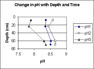
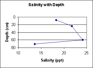
Profile Description:
A1--0 to 8 centimeters; black (5Y 2.5/1), loamy coarse sand; 35 percent mixed rock fragments and 3 percent shell fragments; clear.
AC--8 to 24 centimeters; coarse sand; 45 percent mixed rock fragments and 1 percent shell fragments; clear.
C1--24 to 60 centimeters; coarse sand; 55 percent mixed rock fragments and 20 percent shell fragments; clear.
C2--60 to 70 centimeters; coarse sand; 40 percent mixed rock fragments and 3 percent shell fragments.
Map Unit Description (Bradley Stolt):
Gi(B) – Glacial Fluvial Outcrop Island, 2 – 4% slopes: These soils are found on glacial fluvial outcrops found in the middle of Ninigret Pond and in mainland coves. They are islands of glacial fluvial material surrounded by the high N-value Lagoon Bottom or Mainland Cove deposits. The subaqueous soils of this unit are dominated by black and dark olive gray loamy sand and coarse sand with 5– 60% gravels and cobbles in almost all horizons. Typically, surface ‘A’ horizons display black iron mono-sulfide coatings. Soils are typically classified as Sodic Endoaquents with inclusions of Typic Fluvaquents. Shell fragments larger than 2 mm may comprise > 20% of surface horizons. Water depths range from 0.8 m to 1.4 m along the edges of the unit. Submerged topography is moderately sloping toward deeper portions of the pond. Eelgrass cover is low (<10%).
Field Description:
|
Horizon |
Depth (cm) |
Boundary |
Field |
n-value |
Munsell |
Munsell |
Redox features |
Field |
Shell |
|
|
lower |
Dist. |
Texture |
|
Color |
Color |
Color/Conc. |
Coarse |
Frags % |
|
|
boundary |
|
Class |
|
(matrix) |
Name |
|
Frags % |
|
|
A |
8 |
c |
grlcos |
|
5Y 2.5/1 |
black |
|
35% |
3% |
|
AC |
24 |
c |
vgrcos |
|
5Y 3/1 |
very dark gray |
|
45% |
1% |
|
C1 |
60 |
c |
vgrcos |
|
5Y 4/1 |
dark gray |
|
55% |
20% |
|
C2 |
70 |
|
vgrcos |
|
5Y 3/2 |
dark olive gray |
|
40% |
3% |
Lab Analysis:
|
Horizon |
Depth (cm) |
% Coarse Frags |
% Shell Frags |
% VCO (1-2 mm) |
% CO (1-0.5 mm) |
% M (0.5-0.25 mm) |
% F (0.25-0.1 mm) |
% VF (0.1-0.05 mm) |
% Total Sand |
% Silt |
% Clay |
USDA Texture Class |
|
A1 |
8 |
34.42 |
3.12 |
19.2 |
32.3 |
8.9 |
15 |
15.3 |
90.7 |
7.3 |
2 |
grcos |
|
AC |
24 |
55.34 |
0.66 |
34.2 |
32.7 |
7.9 |
4.4 |
14.2 |
93.4 |
4.6 |
2 |
vgrcos |
|
C1 |
60 |
42.19 |
14.86 |
30.9 |
34 |
9 |
0.5 |
13 |
87.4 |
8.6 |
4 |
vgrlcos |
|
C2 |
70 |
41.68 |
3.6 |
35 |
40 |
9.8 |
1 |
10 |
95.8 |
3.2 |
1 |
vgrcos |
Chemical Properties:
|
Horizon |
Depth (cm) |
Total Nitrogen (%) |
AVS (ug/g) |
CRS (ug/g) |
CaCO3 (%) |
Organic Carbon (%) |
|
A1 |
8 |
0.000 |
6 |
298 |
0.806 |
0.523 |
|
AC |
24 |
0.000 |
0.0 |
95.3 |
0.554 |
0.575 |
|
C1 |
60 |
0.029 |
0.0 |
31.2 |
8.988 |
1.286 |
|
|
|