|
Print Date: |
06/15/2004 |
||||||||||||||||||||||||||||||||||||||||||||||||||||
|
Description Date: |
09/14/2000 |
||||||||||||||||||||||||||||||||||||||||||||||||||||
|
Describer: |
Mike Bradley |
||||||||||||||||||||||||||||||||||||||||||||||||||||
|
|
|||||||||||||||||||||||||||||||||||||||||||||||||||||
|
Site ID: |
Ninigret059 |
||||||||||||||||||||||||||||||||||||||||||||||||||||
|
Site Notes: |
Bucket Auger |
||||||||||||||||||||||||||||||||||||||||||||||||||||
|
Pedon ID: |
Ninigret059 |
||||||||||||||||||||||||||||||||||||||||||||||||||||
|
Pedon Notes: |
|
||||||||||||||||||||||||||||||||||||||||||||||||||||
|
Lab Source ID: |
URI |
||||||||||||||||||||||||||||||||||||||||||||||||||||
|
Lab Pedon #: |
|
||||||||||||||||||||||||||||||||||||||||||||||||||||
|
|
|||||||||||||||||||||||||||||||||||||||||||||||||||||
|
|||||||||||||||||||||||||||||||||||||||||||||||||||||
|
|
|||||||||||||||||||||||||||||||||||||||||||||||||||||
|
Pedon Type: |
|
||||||||||||||||||||||||||||||||||||||||||||||||||||
|
Pedon Purpose: |
Research – Masters Thesis |
||||||||||||||||||||||||||||||||||||||||||||||||||||
|
Taxon Kind: |
|
||||||||||||||||||||||||||||||||||||||||||||||||||||
|
Associated Soils: |
|
||||||||||||||||||||||||||||||||||||||||||||||||||||
|
|
|||||||||||||||||||||||||||||||||||||||||||||||||||||
|
Location Information |
|||||||||||||||||||||||||||||||||||||||||||||||||||||
|
Country: |
USA |
||||||||||||||||||||||||||||||||||||||||||||||||||||
|
State: |
RI |
||||||||||||||||||||||||||||||||||||||||||||||||||||
|
County: |
Washington |
||||||||||||||||||||||||||||||||||||||||||||||||||||
|
MLRA: |
149B |
||||||||||||||||||||||||||||||||||||||||||||||||||||
|
Soil Survey Area: |
|
||||||||||||||||||||||||||||||||||||||||||||||||||||
|
Quad Name: |
Quonochataug |
||||||||||||||||||||||||||||||||||||||||||||||||||||
|
|
|||||||||||||||||||||||||||||||||||||||||||||||||||||
|
Location Description: |
Ningiret Pond, Charlestown, RI Southeast of Grassy Point |
||||||||||||||||||||||||||||||||||||||||||||||||||||
|
Legal Description: |
|
||||||||||||||||||||||||||||||||||||||||||||||||||||
|
|
|||||||||||||||||||||||||||||||||||||||||||||||||||||
|
Latitude: |
41 degrees 21 minutes 36.38 seconds north |
||||||||||||||||||||||||||||||||||||||||||||||||||||
|
Longitude: |
71 degrees 39 minutes 12.70 seconds west |
||||||||||||||||||||||||||||||||||||||||||||||||||||
|
Datum: |
NAD83 |
||||||||||||||||||||||||||||||||||||||||||||||||||||
|
UTM Zone: |
19 |
||||||||||||||||||||||||||||||||||||||||||||||||||||
|
UTM Easting: |
278043 meters |
||||||||||||||||||||||||||||||||||||||||||||||||||||
|
UTM Northing: |
4582131 meters |
||||||||||||||||||||||||||||||||||||||||||||||||||||
|
|
|||||||||||||||||||||||||||||||||||||||||||||||||||||
|
|||||||||||||||||||||||||||||||||||||||||||||||||||||
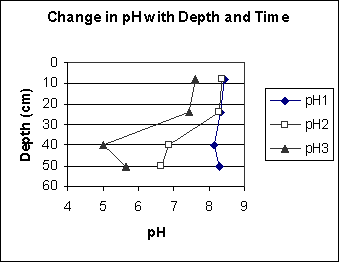
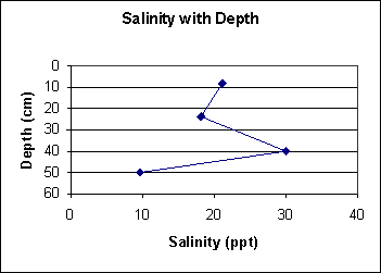
Profile Description:
A1--0 to 8 centimeters; black (5Y 2.5/1), loamy coarse sand; 30 percent mixed rock fragments and 1 percent shell fragments; clear.
AC--8 to 24 centimeters; coarse sand; 45 percent mixed rock fragments and 1 percent shell fragments; abrupt.
C1--24 to 40 centimeters; sand; very dark gray (5Y 3/1) mottles; abrupt.
2C--40 to 50 centimeters; very dark gray (5Y 3/1), coarse sand; 60 percent mixed rock fragments.
Map Unit Description (Bradley Stolt):
Gch(D) – Mid-lagoon Channel, > 6% slopes: These soils are found in a mid-lagoon channel which is the primary conduit of tidal water to and from the west basin of Ninigret Pond. The subaqueous soils of this unit are dominated by black and dark olive gray loamy sand and coarse sand with 15 – 60% gravel and cobbles in almost all horizons. Typically, ‘A’ horizons display black iron mono-sulfide coatings. These soils classify as Typic Endoaquents. Water depths are the deepest in Ninigret Pond (1.4 m – 2.3 m) and slopes are steep (>10%) to the channel bottom. Eelgrass is absent.
Field Observation:
|
Depth (cm) |
Boundary |
Field |
n-value |
Munsell |
Munsell |
Redox features |
Field |
Shell |
Notes |
|
lower |
Dist. |
Texture |
|
Color |
Color |
Color/Conc. |
Coarse |
Frags % |
|
|
boundary |
|
Class |
|
(matrix) |
Name |
|
Frags % |
|
|
|
8 |
c |
grlcos |
|
5Y 2.5/1 |
black |
|
30% |
< 1% |
*1 |
|
24 |
a |
vgrcos |
|
5Y 3/1 |
very dark gray |
|
45% |
1% |
|
|
40 |
a |
s |
|
5Y 4/2 |
olive gray |
|
|
|
*2 |
|
50 |
|
vgrcos |
|
5Y 3/1 |
very dark gray |
|
60% |
|
|
*1. Annelid activity
*2. Common mottles of 5Y 3/1
Laboratory Analysis:
|
Horizon |
Depth (cm) |
% Coarse Frags |
% Shell Frags |
% VCO (1-2 mm) |
% CO (1-0.5 mm) |
% M (0.5-0.25 mm) |
% F (0.25-0.1 mm) |
% VF (0.1-0.05 mm) |
% Total Sand |
% Silt |
% Clay |
USDA Texture Class |
|
A1 |
8 |
40 |
1.5 |
15.4 |
27 |
19.7 |
22.5 |
6.7 |
91.3 |
5.7 |
3 |
vgrcos |
|
AC |
24 |
54.7 |
0.62 |
28 |
29.5 |
13.5 |
16.7 |
4.6 |
92.3 |
4.7 |
3 |
vgrcos |
|
C1 |
40 |
6.46 |
0 |
4.8 |
19.4 |
30 |
26 |
15.4 |
95.6 |
3.4 |
1 |
s |
|
2C |
50 |
48.29 |
0.03 |
28.8 |
32 |
16.5 |
13 |
5.9 |
96.2 |
2.8 |
1 |
vgrcos |
Chemical Properties:
|
Horizon |
Depth (cm) |
Total Nitrogen (%) |
AVS (ug/g) |
CRS (ug/g) |
CaCO3 (%) |
Organic Carbon (%) |
|
A1 |
8 |
0.046 |
17 |
326 |
0.407 |
0.733 |
|
AC |
24 |
0.040 |
0.0 |
138.9 |
0.524 |
0.486 |
|
C1 |
40 |
0.000 |
0.0 |
84.5 |
0.293 |
0.358 |
|
|
|