Soil Survey of Bristol County, Massachusetts
NORTHERN PART

The following Map Unit Description is from the 1981 Soil Survey of Bristol County, NORTHERN Part. Please note: map unit symbols are DIFFERENT for Bristol North and Bristol South reports, do NOT use these descriptions for Bristol South.
StA-Sudbury fine sandy loam, 0 to 3 percent slopes. This soil is deep, nearly level, and moderately well drained. It is on outwash plains. The mapped areas are irregular in shape and generally range from 5 to 25 acres in size. Slopes are commonly smooth and are 100 to 500 feet long.
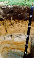
Typically, the surface layer is very friable, dark brown fine sandy loam about 6 inches thick. The very friable subsoil is 16 inches thick. In sequence from the top, the upper 4 inches of the subsoil is brown fine sandy loam, the middle 7 inches is yellowish brown fine sandy loam, and the lower 5 inches is yellowish brown gravelly sandy loam that has strong brown and light brownish gray mottles. The mottled substratum to a depth of 60 inches is very friable, light olive brown loamy fine sand in the upper 7 inches; loose, yellowish brown gravelly loamy sand in the next 11 inches; and loose, light olive brown gravelly coarse sand in the lower 20 inches.
Included with this soil in mapping are areas of Merrimac and Walpole soil that are generally less than 4 acres in size. Also included are areas of soils that have a surface layer and subsoil of loamy sand, and areas of soils that are mottled at a depth of between 24 and 40 inches. The included soils make up about 20 percent of the map unit.
Permeability is moderately rapid in the subsoil and rapid in the substratum. Available water capacity is moderate. Reaction ranges from extremely acid to medium acid. The root zone extends into the substratum. Root growth is restricted by a seasonal high water table which is in the lower part of the subsoil in winter and spring.
This soil has good potential for farming, and most acreage has been farmed. It has poor potential for urban use and for sanitary waste disposal facilities. The soil has good potential for trees and for openland and woodland wildlife habitat. Some areas of soil have been developed for homesites and commercial use, and some acreage has reverted to or has been planted in trees.
The soil is suited to cultivated crops, hay, and pasture. Good tilth is easily maintained. The hazard of erosion is slight. Wetness is the major concern of management. Conservation management includes installing field drains where needed, improving tilth, and increasing organic-matter content. If this soil is farmed, use of cover crops, incorporating grasses and legumes in the cropping system, and mixing crop residue and animal manure into the plow layer help to improve tilth and increase organic-matter content. Proper stocking rates, deferred grazing, and pasture rotation are management practices that help to maintain desirable pasture plants.
The soil is well suited to trees, but only a small acreage is in woodland. Productivity is moderate. Important tree species are eastern white pine and northern red oak.
The soil has limitations for most urban use and for sanitary waste disposal facilities because of wetness, seepage, and susceptibility to frost action. Capability subclass IIw.
StB-Sudbury fine sandy loam, 3 to 8 percent slopes. This soil is deep, gently sloping, and moderately well drained. It is on outwash plains. The mapped areas are irregular in shape and generally range from 5 to 25 acres in size. Slopes are commonly smooth and are 100 to 400 feet long.
Typically, the surface layer is very friable, dark brown fine sandy loam about 6 inches thick. The very friable subsoil is 16 inches thick. In sequence from the top, the upper 4 inches of the subsoil is brown fine sandy loam; the next 7 inches is yellowish brown fine sandy loam; and the lower 5 inches is yellowish brown gravelly sandy loam that has strong brown and light brownish gray mottles. The mottled substratum to a depth of 60 inches is very friable, light olive brown loamy fine sand in the upper 7 inches; loose, yellowish brown gravelly loamy sand in the next 11 inches; and loose, light olive brown gravelly coarse sand in the lower 20 inches.
Included with this soil in mapping are areas of Merrimac and Walpole soils that are generally less than 4 acres in size. Also included are areas of soils in which the surface layer and subsoil are loamy sand and areas of soils that are mottled at a depth of between 24 and 40 inches. These included soils make up about 20 percent of the map unit.
Permeability is moderately rapid in the subsoil and rapid in the substratum. Available water capacity is moderate. Reaction ranges from extremely acid to medium acid. The root zone extends into the substratum, but root growth is restricted by a seasonal high water table which is in the lower part of the subsoil in winter and spring.
This soil has good potential for farming, and most acreage has been farmed. It has poor potential for urban use and for sanitary waste disposal facilities. The soil has good potential for trees and for open land and woodland wildlife habitat. Some areas of soils have been developed for homesites and commercial use, and some acreage has reverted to or has been planted in trees.
The soil is suited to cultivated crops, hay, and pasture. Good tilth is easily maintained. The hazard of erosion is moderate. Wetness is the major concern of management. Conservation management includes installing field drains where needed, controlling erosion, improving tilth, and increasing organic-matter content. If this soil is farmed, the use of minimum tillage, cover crops, and grasses and legumes in the cropping system help to reduce runoff and control erosion. Mixing crop residue and animal manure into the plow layer helps to improve tilth and increase organic-matter content. Proper stocking rates, deferred grazing, and pasture rotation are management practices that help to maintain desirable pasture plants.
The soil is well suited to trees, but only a small acreage is in woodland. Productivity is moderate. Important tree species are eastern white pine and northern red oak.
The soil has limitations for most urban use and for sanitary waste disposal facilities. Wetness, seepage, and susceptibility to frost action are limitations. Capability subclass IIw.