Eastern Massachusetts Digital Soil Survey CD Version 2.0
Digital Soil Data now available from Web Soil Survey
CD Discontinued
Jump to Attribute tables
This CD is not an official or authorized USDA-NRCS soil survey product,
for info on official SSURGO soils data click
HERE).
To
Obtain a Copy of this CD email your inquiry to
jimturenne@gmail.com I will reply with
information.
Special Note on CD (June 2004): Due to a high demand
for this CD, and certain circumstances which require me to distribute this CD on
my own expense, there is now a $5.00 charge for the CD to
cover postage and cost of blank CD. Digital soil information can be
downloaded from MassGIS or the NRCS but attribute data is not provided. Sorry
for this change in policy.
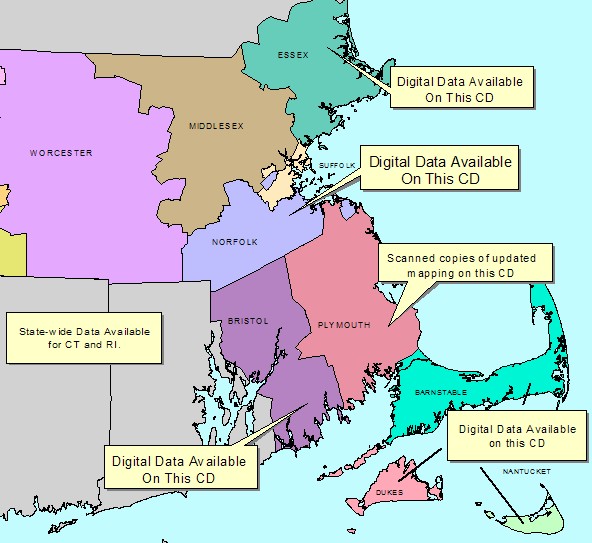
This CD was created to provide digital (GIS) soil survey data for Eastern Massachusetts area. It consists of digital soils data for the counties of Barnstable, Bristol, Dukes, Essex, Nantucket, Norfolk, and Suffolk Massachusetts, along with scanned copies of the field map sheets for areas updated in Plymouth County Massachusetts. In addition to the updated Plymouth County mapping, scanned copies of the 1969 Soil Survey of Plymouth County, map unit descriptions from the published soils surveys, along with the entire NEsoil.com web site for off-line viewing
The digital soil data includes soil attribute information to provide interpretive information such as hydric soils, suitability for onsite septic systems, hydrologic soil groups, etc. A field is also added to the attribute table which links soil polygons to the complete map unit descriptions from the published soil reports via the Internet. This attribute data is not usually directly provided with digital soil data, making the digital soil difficult to use for those not familiar with GIS. In addition to the modified soil data the CD also contains MS Access database files for producing interpretive tables for the county soil reports. Other files and programs are also provided (read the CD contents for more information).
Comments and feedback on this CD are welcome. Please note this CD is a personal product created by Jim Turenne to provide digital soils information in a user-friendly format. It is NOT a USDA-NRCS product and was NOT created using government time or equipment.
The following are instructions for using the soils data on the SEsoil CD.
For some basic instructions on using ArcView GIS Click HERE.
Note: The CD does NOT include any base map such as ortho photography or topographic maps. To load ortho images onto the county views try the MIT ortho server extension for ArcView: http://tull.mit.edu/MITOrtho/arcview.html
You can also image date free from MassGIS: http://tull.mit.edu/MITOrtho/arcview.html or you can add the soil coverages on the CD tothe MassGIS dataviewer.
As of December, 2003 digital soil survey information is available for Barnstable, Bristol, Dukes, Essex, Nantucket, Norfolk, and Suffolk Counties Massachusetts (other counties are also available for other parts of Massachusetts). There are two sources of digital soils information in Massachusetts for use with a Geographic Information System (GIS) program. One source is from the USDA NRCS Soil Survey Geographic Database (see: http://www.ncgc.nrcs.usda.gov/branch/ssb/products/ssurgo/ for SSURGO information). Another source for digital soil data is from Mass/GIS (http://www.state.ma.us/mgis/soi.htm). If you want to use the soil data with other data in Massachusetts, I recommend getting it from MassGIS. Soil data from Mass/GIS is available by County and is projected in Massachusetts State Plane, NAD 83 coordinates.
Click Here for a list of files and programs contained on the CD
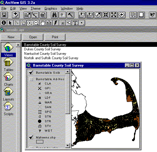
Running and Using the sesoilX.apr files:
The folder called "Sesoil" on this CD contains digital soil data for Southeastern Massachusetts. The digitized mapping is the same as the published soil surveys with some minor line and soil map unit changes made to conform to the base map imagery (consult the metadata for complete information - metadata is located in the sesoil/county folder called ma##.met). The development of this CD spans several years and each County may have different data structure and attribute information than what is describe below. All of the digital data on the Arc View project files are in Massachusetts State Plane, NAD 83 coordinate system; some of the Counties also contain the original downloaded SSURGO data in UTM projection (navigate to the county folder to check).
ArcView project files called "sesoilX.apr" (where X is a drive letter such as C or d DRIVE) are located in the main Sesoil folder. To open the ArcView project file double click the sesoilX.apr file that matches your drive letter (for example if you want to run from your CD and your CD drive letter is "D" double click the sesoilD.apr). Once the APR file is running your ArcView project should look like the following:
NOTE: Hydrography (streams) included may not match the hydrography from the published soil survey maps. The hydrography on the CD was clipped from the 25K hydro coverage on the MassGIS dataviewer.
Each county soil survey is set as individual views in the main document
window. Opening the view for the county you are interested in will provide the
soil polygons, Ad-hoc spot points and lines, and other index coverages. You will notice that
the "Hotlink" button ![]() is active when the soil
theme is active. This feature allows you to link the soil polygons to map unit
descriptions, provided you are connected to the Internet. To use this feature
make the soil poly theme active, click the "Hot Link" button, then click on a
polygon. If this does not work contact me for help.
is active when the soil
theme is active. This feature allows you to link the soil polygons to map unit
descriptions, provided you are connected to the Internet. To use this feature
make the soil poly theme active, click the "Hot Link" button, then click on a
polygon. If this does not work contact me for help.
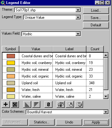
As mentioned above I modified the original soil polygon attribute table with a join table to provide information to create interpretive maps. In order to view the soil interpretive maps double click the countysoil.shp shape file to open the legend editor. In the "Legend Type" box select "Unique Value", in the "Values Field" navigate to the field you want to create as shown below (explanations of each field is provided below):
You may want to edit the symbols to suit your needs.
NOTE: UNC means the field is not classified refer to map unit description for more information. ESWT = Estimated Depth to Seasonal High Watertable (Click for more information)
MAPUNIT: This field contains the alpha and or alphanumeric map unit symbol used to join with the STATELEG filed of the soil attribute table. The numbers are the soil map units used on our state-wide soil legend. A field called "CODE" has the published alpha map unit symbol such as HfC.
UNITNAME: This field has the soil map unit name from the published soil survey .
This field lists a brief description of the soil map unit, grouping properties such as depth to watertable, drainage, and other features. The following table describes the fields and provides some information about development potential/limitations:
| Field Name | Description |
| Bedrock Controlled Uplands. | Areas with a shallow depth to bedrock soils and
rock outcrops. Generally poorly suited for development due to shallow soil depth. |
| Coastal dunes and beaches. | Groups both vegetated and non-vegetated dunes
and coastal soils. Very poorly suited to development due to severe erosion. |
| ESHWT > 4.0 feet, rapid permeability. (NOTE: These depths to ESWT may not be the same depth listed in the published soil survey tables, see the report for ESWT depth ranges). |
Soils with depth to seasonal high watertable (ESWT)
greater than 5 feet below the surface and rapid permeability substratum. Generally suited for development, BUT also associated with aquifer recharge areas. |
| ESHWT > 4.0 feet, slow permeability. (NOTE: These depths to ESWT may not be the same depth listed in the published soil survey tables, see the report for ESWT depth ranges). |
Soils with depth to watertable greater than 5
feet below the surface and slow permeability substratum. Generally suited for development, poorly suited to onsite septic systems. |
| ESHWT 1.5 to 4.0 feet, rapid permeability. (NOTE: These depths to ESWT may not be the same depth listed in the published soil survey tables, see the report for ESWT depth ranges). |
Soils with depth to APPARENT watertable between
1.5 to 4 feet below the surface. Generally moderate constraints to development, subsurface drains are needed and mounded septic systems. Associated with aquifer recharge areas. |
| ESHWT 1.5 to 4.0 feet, slow permeability. (NOTE: These depths to ESWT may not be the same depth listed in the published soil survey tables, see the report for ESWT depth ranges). |
Soils with depth to PERCHED watertable between
1.5 to 4 feet below the surface. Generally moderate constraints to development, subsurface drains are needed and mounded septic systems. Slowly pervious layer may restrict septic systems. |
| Floodplain soils. | Soils in modern-day floodplains, subject to
inundation by flooding. Very poorly suited to development due to flooding. |
| Human Altered, cuts and fills. | Areas altered by human activity. Includes areas
of fill and areas cut down to the geologic deposits. Variable soil conditions, onsite investigations needed to determine development potential. |
| Hydric soils. | Poorly and very poorly drained soils associated
with wetland areas. Very poorly suited to development due to extreme wetness. |
| Landfills/Dumps. | Areas used for refuse disposal. Very poorly suited for development due to subsidence and environmental hazards. |
| Water. | Open water bodies including ponds, lakes, rivers, reservoirs and oceans. |
ONSEW: Onsite Sewage Disposal
This rating is designed to show soil ability to deliver household sewage effluent into the soil under the State (Massachusetts) Environmental Code Title V: Minimum Requirements for the Subsurface Disposal of Sanitary Sewage (310 CMR 15.00). The interpretive groups are developed to provide general site characteristics for soil requirements.
This information is intended for general planning purposes only and is not, in any way, intended to replace or supercede an on-site investigation. On-site investigations for siting septic systems by certified soil evaluators are required by Title V.
These classes are designed for the installation of new septic systems for new single-family residences and do not apply to large systems or commercial/industrial systems. These classes are only designed for the soils mapped in Southeastern Massachusetts.
The general requirements relating to soil suitability for onsite sewage disposal systems in Massachusetts are;
Based on this criteria, the onsite sewage disposal classes were developed by grouping soil properties such as depth to seasonal high watertable, permeability, depth to bedrock, type of parent material, and drainage class together. The following table lists the onsite sewage disposal classes (A through I), a brief description of the class, and the relation to the Massachusetts Title V code for siting onsite septic disposal systems within this type of soil.
|
On-site Sewage Disposal Class |
Class Description | Massachusetts Title V Relation |
|
A |
This group consists of soil map units that have a depth to seasonal high water table greater than 60 inches, depth to bedrock is greater than 60 inches, and permeability of the substratum is rapid to very rapid to a depth of 72 inches. | Generally well suited soil for on-site sewage systems. These areas are often associated with aquifer recharge zones. Nitrate reduction systems may be required in some areas. |
|
B |
This group consists of soil map units that have a depth to seasonal high water table between 1.5 and 60 inches below the surface, depth to bedrock is greater than 60 inches, and permeability of the substratum is rapid to very rapid. | Generally, these areas require a mounded system so the bottom of the leach field is 4 to 5 feet (depending on the percolation rate) above the seasonal high watertable. Some areas may be required to install nitrate reducing alternative systems to protect the aquifer. |
|
C |
This group consist of soil map units that have a depth to seasonal high water table greater than 60 inches, depth to bedrock is greater than 60 inches, and permeability of the substratum is moderate to very slow within a depth of 72 inches. | These soils generally have a restrictive layer
within 72 inches and on-site exploration is often required to locate the
four feet of pervious material. Removal of the slowly permeable material is
often needed and suitable fill material needs to be brought in. The restrictive material is usually dense till, lacustrine silts and clays, human transported fill, or ice contact material. |
|
D |
This group consist of soil map units that have a depth to seasonal high water table between 1.5 and 60 inches below the surface, depth to bedrock is greater than 60 inches, and permeability of the substratum is moderate to very slow within a depth of 72 inches. | Generally, these areas require mounded systems and extensive on-site exploration to locate the required four feet of pervious material. Removal of the restrictive layer is often required and suitable fill must be brought in to replace the slowly pervious material. |
|
E |
This group consists of coastal dunes, beaches and alluvial (floodplain) soils, subject to wave, tidal, coastal storm action and flooding by streams and rivers. | These areas are considered velocity zones and floodways under Title V (see 310 CMR 15.213). |
|
F |
This group consists of areas where the soils are saturated, flooded, or ponded long enough during the growing season to develop anaerobic conditions in the upper part (hydric soils). | Hydric soils are associated with wetland areas and are subject to protection under state and federal laws. Onsite systems on these areas are required to be mounded 4-5 feet above the surface. Organic soils need to have the organic material removed and replaced with suitable fill material. Glacial till and lacustrine soils often have a restrictive layer. |
|
G |
This group consists of areas that have been altered by human activities such as gravel, till, and quarry pits, human transported fill, and sanitary landfills. Also included are miscellaneous non-soil areas. | On-site investigation is required to determine the extent and type of alteration. Some of these areas have been excavated (cut) down to the soil parent material (un-weathered geologic material), and other areas have had material placed over the original soil area (fill). The Title V code requires four feet of naturally - occurring pervious material for the proposed soil absorption system. |
|
H |
This group consists of complex areas of very deep to shallow depth to bedrock soils. | On-site investigation is needed to locate the very deep soils to have the required four feet of pervious material. |
|
I |
Areas covered with more than 75 percent impervious material (pavement, buildings, etc). | These areas are generally sewered, on-site investigations are needed to determine soil conditions. |
Dual classes may be assigned to soil complexes such as A/B for map unit 478B-Plymouth-Poquonock complex. The first class (A) is the rating for the Plymouth soil component and the second (B) is the rating for Poquonock soils. Complexes that have the same rating are not assigned dual classes (example: map unit 480 Plymouth-Carver complex, both are class A units).
HYDRIC:Hydric Soils
This theme map shows hydric and non-hydric soil areas. Hydric soils are soils that are saturated, flooded, or ponded long enough during the growing season to develop anaerobic conditions in the upper part. Hydric soils are generally associated with wetlands and are subject to protection under State and Federal laws. Remember; all soil map units may contain inclusions of hydric and non hydric soils, onsite determination is required to delineate wetlands!! Most published soil surveys are mapped at a scale of 1:20,000 to 1:25,000 with minimum delineation's of 5-8 acres in size. In addition to the soil polygons, always check the Ad Hoc spot symbols for the wet spot and the swamp or marsh symbol. These are small wetland areas in an upland soil polygon.
| Field Name | Description |
| Coastal dunes and beaches | Generally these are not hydric soils but are protected areas. |
| Hydric soil, cranberry beds | Hydric soil areas used for the production of cranberries. Included with this theme are abandoned cranberry beds. |
| Hydric soil, mineral | Hydric soils formed in less than 16 inches of organic material. |
| Hydric soil, organic | Hydric soils formed in greater than 16 inches of organic materials. Includes both tidal and fresh water organic soils. |
| Upland soils | Non-hydric soil areas which may have small inclusions of hydric soils. |
| Water | Ponds, rivers, lakes, and reservoirs. |
AGRIC: Agricultural Interpretation:
This theme map groups soil map units into a farmland classification scheme developed by the USDA-NRCS.
| Farmland of State or local importance | State or locally important farmland soils are those that fail to meet one or more of the requirements of prime farmland, but are important for the production of food, feed, fiber or forage crops. They include those soils that are nearly prime farmland and that produce high yields of crops economically when treated or managed according to acceptable farming methods. Some may produce as high a yield as prime farmlands if conditions are favorable. |
| Non Prime or Important farmland map units | Soil areas which are generally not well suited for agricultural production because they are either too wet, steep, stony, disturbed, or dry for agricultural use. |
| Prime farmland map units | Prime farmland soils are those that have the best combination of physical and chemical characteristics for producing food, feed, forage, fiber, and oilseed crops, and are also available for these uses (the soil's use could be cropland, pastureland, forest land, or other land, but not urban built-up or water). It has the soil quality, growing season, and moisture supply needed to produce sustained high yields of crops economically when treated and managed, including water management, according to acceptable farming methods. In general, prime farmland soils have adequate and dependable precipitation, a favorable temperature and growing season, acceptable acidity or alkalinity, and few or no surface stones. They are permeable to water and air. Prime farmland soils are not excessively erodible or saturated with water for a long period of time, and they either do not flood frequently or are protected from flooding. |
| Unique farmland soils | Cranberry bed areas. |
| Water | Ponds, rivers, lakes, and reservoirs. |
GEOLOGIC (Soil Parent Material):
This theme map groups soil map units according to the parent material (geologic sediments ) the soil formed in. Types of parent material (referred to as the substratum) in Massachusetts soils are broken down into two major categories; glacial deposits and post-glacial deposits. Glacial deposits are mostly of Pleistocene age, and post-glacial deposits are Holocene age. This field may be used for title V soil evaluations (office review of site - page 1 of the log form) in areas where surficial geology maps are not available.
| Ablation till | Unsorted, non-stratified material deposited by glacial ice and consisting of a heterogeneous mixture of clay to boulder size particles. Ablation till is very variable but tends to be loose and dominantly sandy, but may have lenses of firm loamy material. |
| Basal or Lodgement Till |
Unsorted, non-stratified material deposited by glacial ice and consisting of a heterogeneous mixture of clay to boulder size particles. Basal till is usually found on drumlins and till ridges. Basal till tends to have a higher percentage of silt and clay than ablation till and is usually very dense. |
| Bedrock controlled Landscape | Complex soil conditions with areas of shallow depth - to - bedrock soils, exposed bedrock outcrops, and very deep soils formed in till. |
| Coastal dunes and beaches | Holocene deposits (post glacial) consisting of sandy material transported and deposited by wind and wave activity. |
| Human Altered Material | Commonly referred to as fill, human - altered/transported material includes a variety of soil and geologic material deposited by human activity. |
| Fluvial, ice contact | Stratified deposits of sand and gravel deposited by melt-water streams flowing from the glacial ice. Ice - contact outwash was deposited adjacent to the glacial ice and typically has large coarse fragements. |
| Lacustrine, deltaic | Sandy sediments deposited into glacial lakes in the form of deltas (delta slope). Usually underlain by silty and clayey lake floor deposits. |
| Lacustrine, lake floor | Well sorted, fine textured sediments deposited on glacial lake bottoms. |
| Organic deposits | Organic material consisting of dead, decomposing plant material more than 16 inches thick. |
| Fluvial, proglacial | Stratified deposits of sand and gravel deposited by melt-water streams flowing from the glacial ice. Proglacial outwash was deposited away from the glacial ice and tends to have small coarse fragments. |
| Recent alluvium | Material deposited by rivers and large streams in present day floodplains. |
| Water | Ponds, rivers, lakes, and reservoirs. |
HYDGRP: Hydrologic Groups
This theme map shows the classification of soil map units according to their hydrologic soil groups.
A hydrologic group is a group of soils having similar runoff potential under similar storm and land cover conditions. Soil properties that influence runoff potential are those that influence the minimum rate of infiltration for a bare soil after prolonged wetting and when not frozen. These properties are depth to a seasonally high water table, intake rate and permeability after prolonged wetting, and depth to a very slowly permeable layer. The influence of ground cover is treated independently.
Classes
The soils in the United States are placed into four groups, A, B, C, and D. In the definitions of the classes, infiltration rate is the rate at which water enters the soil at the surface, and is controlled by the surface conditions. Transmission rate is the rate at which water moves in the soil and is controlled by soil properties..
Definitions of the classes are as follows:
A. (Low runoff potential). The soils have a high infiltration rate even when thoroughly wetted. They chiefly consist of deep, well drained to excessively drained sands or gravels. They have a high rate of water transmission.
B. The soils have a moderate infiltration rate when thoroughly wetted. They chiefly are moderately deep to deep, moderately well drained to well drained soils that have moderately fine to moderately coarse textures. They have a moderate rate of water transmission.
C. The soils have a slow infiltration rate when thoroughly wetted. They chiefly have a layer that impedes downward movement of water or have moderately fine to fine texture. They have a slow rate of water transmission.
D. (High runoff potential). The soils have a very slow infiltration rate when thoroughly wetted. They chiefly consist of clay soils that have a high swelling potential, soils that have a permanent high water table, soils that have a claypan or clay layer at or near the surface, and shallow soils over nearly impervious material. They have a very slow rate of water transmission.
URL:
This field contains the Internet URL used to link the map unit polygon with the soil map unit description. See the directions above on using the Link_URL script to link the polygons.
The following fields are not available on all county views.
SURFTEX:
This field provides the USDA soil texture class of the surface soil horizon. The letters are abbreviations for each soil texture class such as FSL for fine sandy loam.
FROSTACT:
This field lists the potential frost action of the soil. Frost action is the likelihood of upward or lateral expansion of the soil caused by the formation of segregated ice lenses (frost heave) and the subsequent collapse of the soil and loss of strength on thawing. Frost action occurs when moisture moves into the freezing zone of the soil. Temperature, texture, density, permeability, content of organic matter, and depth to the water table are the most important factors considered in evaluating the potential for frost action. It is assumed that the soil is not insulated by vegetation or snow and is not artificially drained. Silty and highly structured clayey soils that have a high water table in winter are the most susceptible to frost action. Well drained, very gravelly, or very sandy soils are the least susceptible. Frost heave and low soil strength during thawing cause damage mainly to pavements and other rigid structures.
DRAINAGE:
This field provides the USDA soil drainage class. The following is a description of each drainage class:
Drainage class (natural): Refers to the frequency and duration of periods of saturation or partial saturation during soil formation, as opposed to altered drainage, which is commonly the result of artificial drainage or irrigation but may be caused by the sudden deepening of channels or the blocking of drainage outlets. Seven classes of natural soil drainage are recognized:
ED - Excessively drained:
Water is removed from the soil very rapidly. Excessively drained soils are commonly very coarse textured, rocky, or shallow. Some are steep. All are free of the mottling related to wetness.SWED - Somewhat excessively drained
: Water is removed from the soil rapidly. Many somewhat excessively drained soils are sandy and rapidly pervious. Some are shallow. Some are so steep that much of the water they receive is lost as runoff. All are free of the mottling related to wetness.MW - Moderately well drained:
Water is removed from the soil somewhat slowly during some periods. Moderately well drained soils are wet for only a short time during the growing season, but periodically they are wet long enough that most mesophytic crops are affected. They commonly have a slowly pervious layer within or directly below the solum, or periodically receive high rainfall, or both.PD - Poorly drained:
Water is removed so slowly that the soil is saturated periodically during the growing season or remains wet for long periods. Free water is commonly at or near the surface for long enough during the growing season that most mesophytic crops cannot be grown unless the soil is artificially drained. The soil is not continuously saturated in layers directly below plow depth. Poor drainage results from a high water table, a slowly pervious layer within the profile, seepage, nearly continuous rainfall, or a combination of these.VP - Very poorly drained:
Water is removed from the soil so slowly that free water remains at or on the surface during most of the growing season. Unless the soil is artificially drained, most mesophytic crops cannot be grown. Very poorly drained soils are commonly level or depressed and are frequently ponded. Yet, where rainfall is high and nearly continuous, they can have moderate or high slope gradients.HYDRICYN:
This field lists weather the soil map unit is hydric or not hydric, see the field HYDRIC above for more information. Y means the soil is hydric, N means it is not hydric. Remember; all soil map units may contain inclusions of hydric and non hydric soils, onsite determination is required to delineate wetlands!! Most published soil surveys are mapped at a scale of 1:20,000 to 1:25,000 with minimum delineation's of 5-8 acres in size.
This field lists the soils risk of corrosion of concrete (CORCON) and Steel (CORSTEEL).
Risk of corrosion pertains to potential soil-induced electrochemical or chemical action that dissolves or weakens uncoated steel or concrete. The rate of corrosion of uncoated steel is related to such factors as soil moisture, particle-size distribution, acidity, and electrical conductivity of the soil. The rate of corrosion of concrete is based mainly on the sulfate and sodium content, texture, moisture content, and acidity of the soil. Special site examination and design may be needed if the combination of factors creates a severe corrosion environment. The steel in installations that intersect soil boundaries or soil layers is more susceptible to corrosion than steel in installations that are entirely within one kind of soil or within one soil layer. For uncoated steel, the risk of corrosion, expressed as low, moderate, or high, is based on soil drainage class, total acidity, electrical resistivity near field capacity, and electrical conductivity of the saturation extract. For concrete, the risk of corrosion is also expressed as low, moderate, or high . It is based on soil texture, acidity, and amount of sulfates in the saturation extract.
CAPCLAS and SUBCLAS:
This field provides the Land Capability Classification. Land capability classification shows, in a general way, the suitability of soils for most kinds of field crops. Crops that require special management are excluded. The soils are grouped according to their limitations for field crops, the risk of damage if they are used for crops, and the way they respond to management. The criteria used in grouping the soils do not include major and generally expensive landforming that would change slope, depth, or other characteristics of the soils, nor do they include possible but unlikely major reclamation projects. Capability classification is not a substitute for interpretations designed to show suitability and limitations of groups of soils for rangeland, for woodland, and for engineering purposes. In the capability system, soils are generally grouped at three levels: capability class, subclass, and unit. Only class and subclass are used in this survey. These levels are defined in the following paragraphs.
Capability classes, the broadest groups, are designated by Roman numerals I through VIII. The numerals indicate progressively greater limitations and narrower choices for practical use. The classes are defined as follows:
Class I soils have few limitations that restrict their use.
Class
II soils have moderate limitations that reduce the choice of plants
or that require moderate conservation practices.
Class III soils
have severe limitations that reduce the choice of plants or that require
special conservation practices, or both.
Class IV soils have very
severe limitations that reduce the choice of plants or that require very
careful management, or both.
Class V soils are not likely to erode
but have other limitations, impractical to remove, that limit their use.
Class VI soils have severe limitations that make them generally
unsuitable for cultivation.
Class VII soils have very severe
limitations that make them unsuitable for cultivation.
Class VIII
soils and miscellaneous areas have limitations that nearly preclude
their use for commercial crop production.
SUBCLAS: Capability subclasses are soil groups within one class. They are designated by adding a small letter, e, w, s, or c, to the class numeral, for example, IIe. The letter e shows that the main limitation is risk of erosion unless close-growing plant cover is maintained; w shows that water in or on the soil interferes with plant growth or cultivation (in some soils the wetness can be partly corrected by artificial drainage); s shows that the soil is limited mainly because it is shallow, droughty, or stony; and c, used in only some parts of the United States, shows that the chief limitation is climate that is very cold or very dry.In class I there are no subclasses because the soils of this class have few limitations. Class V contains only the subclasses indicated by w, s, or c because the soils in class V are subject to little or no erosion. They have other limitations that restrict their use to pasture, rangeland, woodland, wildlife habitat, or recreation. Capability units are soil groups within a subclass. The soils in a capability unit are enough alike to be suited to the same crops and pasture plants, to require similar management, and to have similar productivity. Capability units are generally designated by adding an Arabic numeral to the subclass symbol, for example, IIe-4 or IIIe-6.
The folder called "Sesoil" on this CD contains digital soil data for eastern Massachusetts. The digitized mapping is the same as the published soil surveys with some minor line and soil map unit changes made to conform to the base map imagery (consult the metadata for complete information - metadata is located in the sesoil/county folder called ma##.met or the .xml file). The development of this CD spans several years and each County may have different data structure and attribute information than what is describe below. All of the digital data on the Arc View project files are in Massachusetts State Plane, NAD 83 coordinate system; data is also available in UTM coordinates from the SSURGO download site: http://www.ncgc.nrcs.usda.gov/branch/ssb/products/ssurgo/.
I also included the free Shareware GIS program called ArcExplorer from ESRI (http://www.esri.com/software/arcexplorer/index.html) in the "programs" subfolder (sesoil/programs/ae2setup.exe) in case you do not have ArcView GIS installed. There is an ArcExplorer project file called "sesoilC.aep" in the root directory to view the digital soils with ArcExplorer.
The following is a list of each file and subfolder content in the "Sesoil" directory on the CD and information about each file and folder:
The following is a list of files in each subdirectory (information about each soil survey can be found at: http://nesoil.com). The asterisk * implies that there are several file extension with the same name such as .shp, .dbf, etc.:
Barnstable: Contains the soil survey polygon shapefiles (barnsoil.*) along with the Ad-hoc spot symbol point file (barnspot.*). Descriptions of the Ad-hoc spot symbols can be found at: http://nesoil.com/adhoc/index.htm. The metadata for the SSURGO soil data is located on the ma001.met file (open with any text editor).
Bristol: Has two sub-directories for Bristol North and Bristol South. Each directory has the soil and ad-hoc spot symbols data in Mass. State Plane (NAD83). There is also a copy of a Microsoft Access database (Bristol*.MDB) files for generating interpretive reports.
Dukes: Contains the Dukes County soil survey polygons (dukesoil.*) and Ad-hoc spot and line files (dukespotln.* and dukesspotpt.*). There is also a Cov.zip file that contains the original coverages, downloaded form SSURGO (UTM projection, NAD 83), the Shp.zip file has the original shape files in UTM, NAD 83. The metadata for Dukes County is in the ma007.met file.
Essex: Has two subdirectories for Essex North and South. Each directory has the soil and ad-hoc spot symbols data in Mass. State Plane (NAD83). There is also a copy of a Microsoft Access database (essex*.MDB) files for generating interpretive reports.
Nantucket: Contains the soil survey of Nantucket County polygons (nantsoils.*), Ad-hoc points and lines (nantspotln.* and nanspotpt.*). Two zip files have the original coverages (cov.zip) and shapefiles (shp.zip) in UTM, NAD 83 projection. A Microsoft Access database file called Nantucket.mdb file is also included. If you have MS Access 97 you can run this file to generate the interpretive tables included with the soil report. The metadata is located in the ma019.met file.
Norfolk: Contains the Soil Survey of Norfolk and Suffolk Counties Massachusetts (polys, Adhoc points) and the MS Access 97 database file for generating interpretive data. The metadata is located in the norfolksoilsurvey.met file.
Programs: This folder contains the free ArcExplorer program which you may install if you do not have ArcView GIS (Ae2setup.exe). There is also a Microsoft Access database file called Soilsood.mdb, which has interpretive tables for several counties in Massachusetts.
StatsgoSP: This folder contains the State Soil Geographic Map, which I have reprojected in Mass. State Plane NAD 83 coordinates. STATSGO soil maps are for regional planning purposes and NOT intended for detailed planning uses. The Statsgo_db.pdf file is a users guide for STATSGO data. I also provided the original doc.zip, ma.zip, and spatial.zip files downloaded form the STATSGO web page (http://www.ftw.nrcs.usda.gov/stat_data.html).