 |
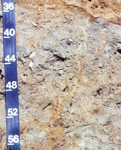 Photo by: Rob Tunstead.
Photo location: |
New England Soil Profiles
Birchwood Series
|
|
Photo by: Rob Tunstead.
Photo location: |
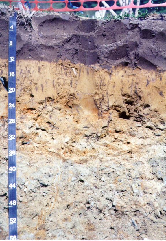
Birchwood soils are moderately well drained soils formed in sandy eolian and/or fluvial material underlain by loamy dense till. This profile has the following morphology: 0-12 inches, Ap horizon -loamy sand. 12-20 inches, Bw1 horizon -loamy sand. 20-34 inches, BC horizon -gravelly loamy sand with many redoximorphic features (seasonal high watertable within 24 inches), 34-65 inches, 2Cd -gravelly fine sandy loam, very firm basal till, many redoximorphic features.
The 2Cd horizon has a vertical desiccation crack (gray surrounded by bright colors), above-right is a close up of the cracks:
Photo Location Map: http://www.topozone.com/map.asp?z=19&n=4646545&e=338991&s=50&size=l&datum=nad83&layer=DRG25
Click here for the full Pedon description of the photo above.
BIRCHWOOD SOIL PROPERTIES:
Taxonomic Classification:
Sandy over loamy, mixed, nonacid, mesic, Aquic Udorthents.
Drainage Class: Moderately
well drained.
Parent Material: Sandy eolian
and/or fluvial material underlain by loamy dense glacial till.
Permeability: Moderately
rapid to rapid in the solum, slow to very slow in the dense
substratum.
Available Water Holding Capacity:
Low.
Soil Reaction: Very strongly
to slightly acid throughout.
Depth to Bedrock: Greater than 65
inches.
Seasonal High Watertable: Depth:
1.5 to 3 feet.
Type: Perched.
Months: November to April.
Hydrologic Group: C.
Hydric Soil: No (may have
hydric inclusions).
Flooding/Ponding Potential: Frequency
and Type: None.
Potential Inclusions:
Moderately well drained Woodbridge, Scituate, and Newfields soils
are on similar landforms. Poorly drained Norwell, and Ridgebury soils are on lower elevations and along drainage-ways.
Well drained Paxton, Poquonock and Montauk soils are on convex
slopes and on higher elevations.