Historic 1963 Publication on the benchmark Paxton Soil
![]()
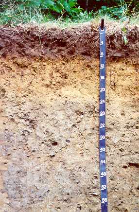
Paxton, Fine Sandy Loam
The Official State Soil of Massachusetts
|
Historic 1963 Publication on the benchmark Paxton Soil
|
|
The Paxton soil series was established in Worcester County Massachusetts in 1922, and is named for the town of Paxton where it was first described and mapped. In 1991, the Massachusetts State Legislature designated the Paxton series as the Official State Soil of the Commonwealth. Paxton soils are mapped predominantly throughout Southern New England and include portions of Maine, New Hampshire and Vermont. Paxton soils occur on about 400,000 acres of the 5.3 million acres in the state. The Paxton series consists of well drained loamy soils formed in sandy loam eolian mantled material underlain by lodgement (dense) till derived mostly from schist, gneiss, and granite. The soils are very deep to bedrock and moderately deep to a densic contact.
Paxton Soil Properties:
Taxonomic Classification:Coarse-loamy,mixed,active,mesic
Oxyaquic Dystrudepts.
Paxton soils are in the Inceptisol soil order of soil taxonomy. The term
"coarse-loamy" indicates that the soil has less than
18% clay and at least 15% or more particles that are fine sand or
coarser. The term "mixed" indicates no single mineral
is over 40 percent. The term "active" represents a
ratio of the cation-exchange capacity to clay of the pedon. The
term "mesic" indicates the soil developed in a
temperature between 8 and 15 degrees C. The "Typic
Dystrudepts" are typical profiles [typic] with low pH
[dystr] with a udic soil moisture regime and are within the
Inceptisol order [epts].
Drainage
Class: Well drained.
Parent
Material: Dense acid glacial till derived mostly from
schist, gneiss and granite.
Permeability:
Moderate in the solum and slow or very slow in the substratum.
Available
Water Holding Capacity: Moderate.
Soil
Reaction (pH): Very strongly acid to moderately
acid throughout.
Depth
to Bedrock: Greater than 60 inches.
Seasonal
High Water Table: Depth = 2.5 to
4 feet, Type = perched, Months
= Jan to May.
Massachusetts Uses of Paxton Soils
Paxton soils in Massachusetts occur predominantly throughout the state but exclude the Cape Cod area as well as Martha's Vineyard and Nantucket islands (MLRA 149B). Where stones have been cleared and slopes are gentle, Paxton soils are well suited to cultivate crops, hay, and improved pasture. Additional land uses include suburban housing and woodland production. The main agricultural uses for Paxton soils are apples, corn, and silage. Paxton soils have a high water holding capacity and are well suited for intensive agricultural and woodland production. Trees commonly growing on Paxton soils include red, white, and black oak, hickory, sugar maple, red maple, gray and black birch, white pine, and hemlock. Paxton soils have slowly permeable dense till layers that perch seasonal water tables. These limitations often interfere with septic systems for commercial and residential development.
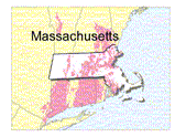
Distribution of Paxton Soils in New England
Paxton Geographic Setting
Paxton soils occur on gently sloping to steep convex slopes. Landforms include till plains, ground moraines, and drumlins. Paxton soils formed in dense acid glacial till derived predominantly from schist, gneiss, and granite. Slopes range from 3 to 35 percent. Mean annual temperature ranges from 45 to 52 degrees F. Mean annual precipitation ranges from 37 to 49 inches. The growing season ranges from 115 to 180 days.
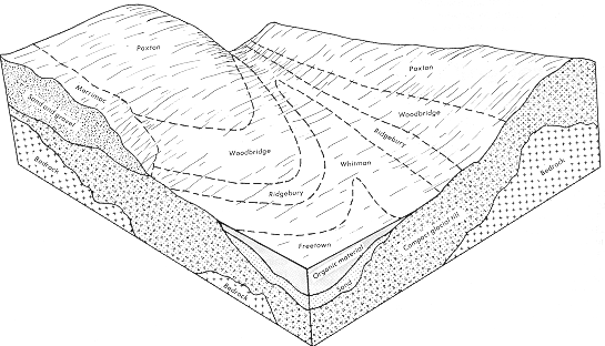
Relationship of the soil, geology and landscape position of a Paxton, Woodbridge, Ridgebury, and Whitman catena. Paxton soils are on convex slopes of drumlins, Woodbridge soils are on sisdeslopes and gently sloping areas, Ridgebury and Whitman soils are on concave slopes and along drainageways.
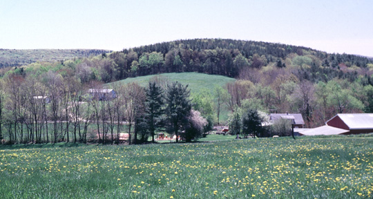
Paxton landscape, the oval shaped hill is called a drumlin which is a smooth, elongated oval hill, mound, or ridge of compact glacial till. The longer axis is parallel to the path of the glacier and commonly has a blunt nose pointing in the direction from which the ice approached..
Some Chemical Properties of the Paxton Soil
Extractable |
Cations |
||||||||
| Horizon | Depth (inches) | pH* | Organic C %** | C.E.C.* | Ca |
Mg |
Na |
K |
Base Sat. % |
Ap |
0-5 |
4.4 |
3.35 |
20.0 |
0.83 |
0.25 |
0.03 |
0.41 |
8 |
Bw1 |
5-12 |
4.4 |
0.75 |
11.7 |
0.22 |
0.04 |
0.02 |
0.25 |
5 |
Bw2 |
12-23 |
4.4 |
0.55 |
10.5 |
0.29 |
0.07 |
0.03 |
0.12 |
5 |
Bw3 |
23-31 |
4.6 |
0.44 |
10.0 |
0.34 |
0.08 |
0.03 |
0.10 |
6 |
2Cd |
31-60 |
4.6 |
0.27 |
9.4 |
0.73 |
0.27 |
0.04 |
0.14 |
13 |
* Analysis by University of Massachusetts Soil
Lab - Log Number 8072-8077. pH 1:1 water method. CEC - NH4OAC pH
7.0 method
** Organic carbon - Walkey - Black method
Some Physical Properties of the Paxton Soil
Horizon |
Depth (inches) |
% Sand |
% Silt |
% Clay |
Textural Class |
Coarse Fragments % |
Bulk Density |
Ap |
0-5 |
49.9 |
34.7 |
15.4 |
Loam |
13.4 |
--- |
Bw1 |
5-12 |
52.8 |
30.8 |
15.4 |
Fine Sandy Loam |
17.0 |
1.55 |
Bw2 |
12-23 |
49.3 |
34.7 |
16.0 |
Loam |
16.0 |
1.60 |
Bw3 |
23-31 |
52.5 |
32.9 |
14.6 |
Fine Sandy Loam |
16.1 |
1.56 |
2Cd |
31-60 |
54.8 |
30.6 |
14.5 |
Fine Sandy Loam |
22.0 |
1.78 |
Back to Images 1 | Back to Images 2