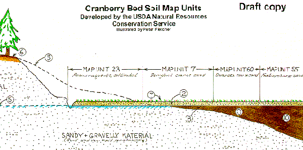
Diagram of cranberry bed soils with apparent water tables. The dashed line (3) represents the original topography before map unit 23 was constructed. The number (5) is the apparent water table.
PLYMOUTH COUNTY, MASSACHUSETTS SOIL SURVEY UPDATE
Cranberry bed soil map units
NOTE: This information is for the updated soil mapping of Plymouth County which has developed soil map units for areas used for cranberry production. The 1969 soil survey mapped all cranberry beds an undifferentiated unit called "Sanded muck".
Using GPR/GPS/GIS to
Inventory Cranberry Beds
UMASS Cranberry Experiment Station
Diagram of cranberry bed soils with apparent water tables. The dashed line
(3) represents the original topography before map unit 23 was constructed. The
number (5) is the apparent water table.
Soil areas used for the production of cranberries (cranberry beds) are delineated on the updated soil maps for Plymouth County, Massachusetts based on the type of soil prior to the construction of the beds. Beds constructed in upland areas are delineated based on the hydrologic conditions (apparent or perched water table) and landscape position (elevation) of the beds in relation to the adjacent "natural" beds constructed in wetlands.
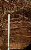
All cranberry bed soils (still in production) consist of a surface layer of sandy fill material (anthro-transported) that was added to the original surface as a management practice (photo above). The thickness of the sandy fill material is variable; typically ranging between 10 to 20 inches thick. A bed that has been in production for several decades has a surface layer consisting of alternating layers of sand and organic material. Below the sandy fill material is the buried soil on which the bed was constructed. The varied soil conditions underlying this upper sandy surface is the basis for separating and delineating the different cranberry bed soil types. The following is a list of cranberry bed soil map units being mapped in Plymouth County Massachusetts (note - slope phases "A" may be left off some maps):
| Map Unit | Map Unit Name | Brief Description |
| 7A | Berryland coarse sand | Mineral soil formed in sandy deposits. |
| 23A | Tihonet coarse sand (formerly called Psammaquents, cultivated) | Recently constructed bed from an upland area with an apparent water table. |
| 26A | Brockton coarse sand (Sippican) | Mineral soil formed in dense till. |
| 27A | Birdsall coarse sand | Mineral soil formed in silty lacustrine deposits. |
| 55A | Freetown coarse sand | Very deep (>51 inches) organic soil. |
| 60A | Swansea coarse sand | Shallow (16 to 51 inches) organic soil. |
| 658 | Epiaquents, cultivated | Recently constructed bed from an upland area with a perched water table (usually > 4 feet higher in elevation than wetland beds). |
| 701 | Cranberry bed, abandoned, mineral | A bed that has been abandoned, the underlying soils are mineral (< 16 inches of peat). |
| 704 | Cranberry bed, abandoned, organic | A bed that has been abandoned, the underlying soils are organic (> 16 inches of peat). |
Map units 55A and 60A are organic soils, (soils formed in deposits of organic material that is greater than 16 inches thick). Swansea (map unit 60) soils have an organic layer under the sandy fill layer ranging from 16 to 51 inches. Below the organic layer is mineral sandy and silty material. Freetown (map unit 55) soils formed in thick organic deposits that are greater than 51 inches thick. In many areas the organic (peat) material is greater than 20 feet thick. These soils typically occur in peat-filled kettle holes or in large basins or depressions. Organic soils (classified as Histosols) are characterized by organic horizons, ranging from undecomposed peat to highly decomposed muck that are more than 16 inches thick and contain more than 20 percent organic carbon. Soils with less than 16 inches of organic horizons are classified as mineral soils.
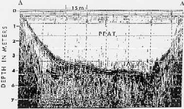
A GPR profile of a peat-filled kettle hole (map unit 55A)
Map units 7A, 26A, and 27A are areas of mineral soils that have less than 16 inches of organic material. The soils are differentiated based on the type of underlying mineral material (geologic deposits) the soil formed in. Berryland (map unit 7A) soils formed in sandy material, Brockton (map unit 26A) soils formed in dense loamy material, and Birdsall (map unit 27) soils formed in silty and clayey deposits.
Cranberry beds that are not constructed in wetland areas (many of the more recently constructed beds) do not have a naturally occurring peat layer in them. Some of these beds use a restrictive layer (natural or artificial) to perch the water above the underlying true water table (map unit 658). Others are constructed by excavating the upland soils (typically sandy soils) down to the water table (apparent water-table) and establishing the bed at that elevation (map unit 23A).
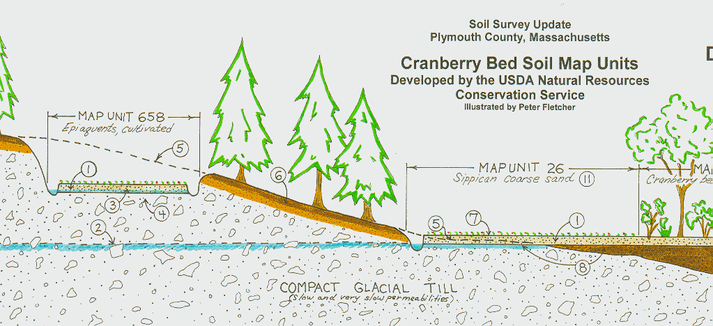
Diagram of an upland bed (Epiaquent soil) with a perched water table and the
natural cranberry bed soils on the lower elevation.
Back to Homepage
Back to Legend
 Cranberry
Bed Soil Profile
Cranberry
Bed Soil Profile