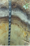
Mashpee Soil Monitoring Well Site
| Print Date: | 08/02/2004 | ||||||||||||||||||||||||||||||||||||||||||||||||||||
| Description Date: | 07/26/2004 | ||||||||||||||||||||||||||||||||||||||||||||||||||||
| Describer: | Rob Tunstead, Melissa Hayden | ||||||||||||||||||||||||||||||||||||||||||||||||||||
| Site ID: | MA023-2004-03705-Mashpee-S | ||||||||||||||||||||||||||||||||||||||||||||||||||||
| Site Notes: | Click for Photo of this pedon | Click here for Water table Data (well Ware02) | ||||||||||||||||||||||||||||||||||||||||||||||||||||
| Pedon ID: | MA023-2004-03705-Mashpee-P | ||||||||||||||||||||||||||||||||||||||||||||||||||||
| Pedon Notes: | |||||||||||||||||||||||||||||||||||||||||||||||||||||
| Lab Source ID: | |||||||||||||||||||||||||||||||||||||||||||||||||||||
| Lab Pedon #: | |||||||||||||||||||||||||||||||||||||||||||||||||||||
| |||||||||||||||||||||||||||||||||||||||||||||||||||||
| Pedon Type: | typical pedon for series | ||||||||||||||||||||||||||||||||||||||||||||||||||||
| Pedon Purpose: | full pedon description | ||||||||||||||||||||||||||||||||||||||||||||||||||||
| Taxon Kind: | series | ||||||||||||||||||||||||||||||||||||||||||||||||||||
| Associated Soils: | Berryland, Deerfield, Freetown, Massasoit, Windsor | ||||||||||||||||||||||||||||||||||||||||||||||||||||
| Location Information | |||||||||||||||||||||||||||||||||||||||||||||||||||||
| Country: | United States | ||||||||||||||||||||||||||||||||||||||||||||||||||||
| State: | Massachusetts | ||||||||||||||||||||||||||||||||||||||||||||||||||||
| County: | PLYMOUTH | ||||||||||||||||||||||||||||||||||||||||||||||||||||
| MLRA: | 149B -- Long Island-Cape Cod Coastal Lowland | ||||||||||||||||||||||||||||||||||||||||||||||||||||
| Quad Name: | Marion | ||||||||||||||||||||||||||||||||||||||||||||||||||||
| Location Description: | USGS Marion quadrangle, Town of Wareham, 1380 ft due West of Squirrel Island Rd, 573 ft due North of Cohackett Brook. | ||||||||||||||||||||||||||||||||||||||||||||||||||||
| Legal Description: | |||||||||||||||||||||||||||||||||||||||||||||||||||||
| Latitude: | 41 degrees 44 minutes 57.40 seconds north | ||||||||||||||||||||||||||||||||||||||||||||||||||||
| Longitude: | 70 degrees 46 minutes 20.90 seconds west | ||||||||||||||||||||||||||||||||||||||||||||||||||||
| Datum: | NAD83 | ||||||||||||||||||||||||||||||||||||||||||||||||||||
| UTM Zone: | 19 | ||||||||||||||||||||||||||||||||||||||||||||||||||||
| UTM Easting: | 352637 meters | ||||||||||||||||||||||||||||||||||||||||||||||||||||
| UTM Northing: | 4623466 meters | ||||||||||||||||||||||||||||||||||||||||||||||||||||
| |||||||||||||||||||||||||||||||||||||||||||||||||||||
| Slope (%) | Elevation (meters) | Aspect (deg) | MAAT (C) | MSAT (C) | MWAT (C) | MAP (mm) | Frost Free Days | Drainage Class | Slope Length (meters) | Upslope Length (meters) |
|---|---|---|---|---|---|---|---|---|---|---|
| 1 | 6 | 140 | poorly |
Oe1--0 to 5 centimeters; very dark brown (7.5YR 2.5/2); low excavation difficulty; clear smooth boundary.
Oe2--5 to 10 centimeters; black (7.5YR 2.5/1); low excavation difficulty; clear smooth boundary.
Oa--10 to 13 centimeters; black (10YR 2/1), highly decomposed plant material; low excavation difficulty; dendritic masses of oxidized iron lining pores; abrupt wavy boundary.
AE--13 to 19 centimeters; 75 percent very dark gray (10YR 3/1) and 25 percent gray (2.5Y 5/1), loamy sand; weak fine and medium subangular blocky structure; very friable; low excavation difficulty; common very fine to medium roots throughout and few coarse roots throughout; dendritic masses of oxidized iron lining pores; 1 percent nonflat subrounded 2- to 75-millimeter mixed rock fragments; strongly acid, pH 5.4, Chlorophenol red; clear wavy boundary.
Eg--19 to 28 centimeters; light gray (10YR 7/1), loamy sand; weak fine and medium subangular blocky structure; very friable; low excavation difficulty; common very fine to medium roots throughout and few coarse roots throughout; 25 percent coarse and very coarse distinct irregular dark grayish brown (10YR 4/2), moist, masses of dark accumulation with clear boundaries throughout; 1 percent nonflat subrounded 2- to 75-millimeter mixed rock fragments; moderately acid, pH 5.6, Chlorophenol red; clear wavy boundary.
Bh1--28 to 34 centimeters; dark reddish brown (5YR 3/2), fine sandy loam; weak fine and medium subangular blocky structure; friable; low excavation difficulty; common very fine to medium roots throughout and few coarse roots throughout; common very fine low-continuity vesicular pores; 15 percent fine distinct threadlike extremely weakly cemented reddish brown (5YR 4/4), moist, manganese coatings with clear boundaries lining pores; 3 percent nonflat subrounded 2- to 75-millimeter mixed rock fragments; moderately acid, pH 5.6, Chlorophenol red; clear wavy boundary.
Bh2--34 to 43 centimeters; dark brown (7.5YR 3/3), fine sandy loam; weak fine and medium subangular blocky structure; friable; low excavation difficulty; few very fine to medium roots throughout and few coarse roots throughout; few very fine low-continuity vesicular pores; 15 percent fine faint threadlike extremely weakly cemented manganese coatings with clear boundaries lining pores; 10 percent nonflat subrounded 2- to 75-millimeter mixed rock fragments; moderately acid, pH 5.6, Chlorophenol red; clear broken boundary.
Bs--43 to 60 centimeters; strong brown (7.5YR 4/6), loamy very fine sand; weak fine and medium subangular blocky structure; friable; low excavation difficulty; few very fine and fine roots throughout; 5 percent fine and medium prominent irregular extremely weakly cemented dark reddish brown (2.5YR 2.5/4), moist, iron-manganese masses with sharp boundaries throughout and 8 percent medium and coarse prominent irregular light yellowish brown (2.5Y 6/3), moist, reduced matrix with clear boundaries throughout and 10 percent medium and coarse distinct irregular yellowish red (5YR 5/8), moist, iron-manganese masses with clear boundaries throughout; 1 percent nonflat subrounded 2- to 75-millimeter mixed rock fragments; moderately acid, pH 5.6, Chlorophenol red; clear wavy boundary.
Cg1--60 to 99 centimeters; light olive brown (2.5Y 5/4), very fine sand; massive; very friable; low excavation difficulty; few very fine and fine roots throughout; 10 percent medium and coarse prominent spherical moderately cemented strong brown (7.5YR 5/6), moist, iron-manganese nodules with clear boundaries throughout and 5 percent medium and coarse prominent spherical moderately cemented dark reddish brown (2.5YR 3/4), moist, iron-manganese nodules with clear boundaries throughout; 1 percent nonflat subrounded 2- to 75-millimeter mixed rock fragments; moderately acid, pH 5.8, Chlorophenol red; clear wavy boundary.
Cg2--99 centimeters; light olive brown (2.5Y 5/3), fine sand; massive; very friable; low excavation difficulty; 5 percent medium and coarse prominent platy extremely weakly cemented yellowish brown (10YR 5/6), moist, iron-manganese nodules with diffuse boundaries throughout and 2 percent medium and coarse prominent platy extremely weakly cemented strong brown (7.5YR 5/6), moist, iron-manganese nodules with clear boundaries throughout; 1 percent nonflat subrounded 2- to 75-millimeter mixed rock fragments; moderately acid, pH 5.8, Chlorophenol red.