Soil Survey of Bristol County, Massachusetts
NORTHERN PART

The following Map Unit Description is from the 1981 Soil Survey of Bristol County, NORTHERN Part. Please note: map unit symbols are DIFFERENT for Bristol North and Bristol South reports, do NOT use these descriptions for Bristol South.
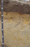
De- Deerfield loamy sand. This soil is deep, nearly level and gently sloping, and moderately well drained. It is on outwash plains. Slopes are smooth (fig. 9) or gently undulating and are 100 to 600 feet long. They are generally less than 3 percent but range to 6 percent in some places. The mapped areas are irregular in shape and are 5 to 40 acres in size.
Typically, the surface layer is very friable, very dark brown loamy sand about 11 inches thick. The subsoil is 15 inches thick. It is loose, yellowish brown sand in the upper part and loose, olive brown sand in the lower part. The substratum to a depth of 60 inches is loose, brown sand in the upper 11 inches and loose, grayish brown sand below. It has yellowish red, yellowish brown, and light brownish gray mottles.
Included with this soil in mapping are areas of Windsor and Wareham soils that are generally less than 4 acres in size. Also included are areas of soils that have somewhat more gravel than is described as typical for this Deerfield soil. Included soils make up about 20 percent of the map unit.
Permeability is rapid in the subsoil and very rapid in the substratum. Available water capacity is low. Reaction ranges from very strongly acid to medium acid. The root zone extends to a depth of about 26 inches. Root growth is restricted by the seasonal high water table.
This soil has fair to poor potential for farming. It has poor potential for most urban use and for sanitary waste disposal facilities. The soil has good potential for trees and fair potential for openland wildlife habitat. Most acreage is wooded. Some acreage is farmed. Some areas of soil are used for homesites.
The soil has limited suitability for farming because of the restricted root zone and low available water capacity. The seasonal high water table is the major concern of management. Fertilizer nutrients are quickly leached away by rapidly percolating water. The hazard of erosion is slight. Conservation management includes frequent irrigation and application of fertilizer, addition of organic matter to the plow layer, and use of cover crops.
The soil is suited to trees and has slight limitation for this use. Productivity is moderate. Important tree species are eastern white pine and northern red oak.
The soil has limitations for most urban use because of the seasonal high water table. The seasonal high water table and rapid permeability are limitations for sanitary waste disposal facilities. Capability subclass IIIw.
Deerfield Official Series Description