USDA -
Natural Resources Conservation Service
Ground
Penetrating Radar Program
Guide
to Interpreting Radar Profiles |
Using GPR to Map Peat Deposits | GPR
Surveys on Cranberry Beds
Instructions
on how to download GPS data and create contour maps
|
|
SIR System -3 GPR unit with a 300 MHz antenna (photo courtesy of GSSI The use of trade names in this article does not constitute endorsement by the USDA)
NRCS GPR
Program
The United States Department of Agriculture,
Natural Resources Conservation Service (USDA-NRCS) has been using
ground-penetrating radar (GPR) technology to study soil subsurface features
since 1979. GPR is a broad band, impulse radar system that has
been specifically designed to penetrate earthen materials. The
GPR unit provides a continuous real-time profile of subsurface
features in soil and geologic deposits.
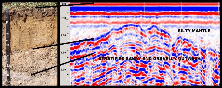
GPR Profile of an area of Bridgehampton and Enfield Soils. The GPR profile
(right) shows the eolian/outwash interface and stratification in the outwash
deposits. Photo (left) is a profile of and Enfield soil series, the
eolian/outwash contact is at 50 to 55 cm.
How Does GPR Work?
The radar transmits high frequency, short
duration pulses of energy into the ground from a coupled antenna.
Transient electromagnetic waves are reflected, refracted, and
diffracted in the subsurface by changes in electrical
conductivity and dielectric properties. Travel times of reflected,
refracted and diffracted waves are analyzed to give depths,
geometry and material type information. The energy returning to
the antenna is processed within the control unit and displayed on
graphic paper.
| GPR Advantages | GPR Limitations |
| Hi resolution, vertically and laterally. | Site specific applications. |
| Rapid. | Generally, shallow depth of observation (1) |
| Cost effective. | |
| Generally, near real time interpretation. | |
| Numerous areas of application. | |
| Non destructive. |
(1) Radar depth of observation; decreases as frequency (antenna) increases, decreases as water content increases, decreases as clay/salt content increases, decreases as scattering increases, increases as transmitter power increases.
NRCS Uses of GPR |
|
|
| Investigating the variability of soil properties. | Mapping peat thickness and volume. | |
| Mapping geologic deposits. | Sedimentation surveys. | |
| Locating buried objects. | Engineering application. | |
| Hydrologic Investigations. | Soil survey investigations. | |
| Locating contamination plumes. | Cultural resources/Archeological investigations. | |
Click Here for A Guide on Interpreting Radar Profiles
GPR Links
Ground
Penetrating Suitability Maps for the U.S.
Geophysical Survey
Systems Inc.
Ground Penetrating Radar from US Radar
Ground
Penetrating Radar Services
GRORADAR Ground Penetrating Radar
Gary R. Olhoeft
http://www.penetradar.com/
http://www.archeologymapping.com/index.htm
http://www.geomodel.com/
http://www.ka.shuttle.de/software/index.html
Sandmeier scientific software
IDS Georadar Division -
Mala Geoscience
Sensors and Software
GPR Data.com


