 Click
here to see a picture of a Hinckley soil
Click
here to see a picture of a Hinckley soilPLYMOUTH COUNTY, MASSACHUSETTS SOIL SURVEY UPDATE
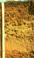
Hinckley Soils: Very deep, nearly level, excessively drained soil formed in gravelly fluvial deposits. Hinckley soils are on terraces, deltas, kames, eskers and large, broad areas on outwash plains.
Click
here to see a picture of a Hinckley soil
Link
to Official Series Description
Hinckley Soil Interpretation
Record (soil 5)
Hinckley Pedon Description 2325301
Hinckley Pedon Description 2325305
Hinckley Pedon Description 2325306
Hinckley Pedon Description 2325307
Map
Unit (s): 253A, 253B, 253C, 253E
Map
Phases:
Taxonomic
Classification: Sandy -skeletal, mixed, mesic, Typic
Udorthents.
Drainage
Class: Excessively drained.
Parent
Material: Gravelly glacial fluvial deposits.
Permeability:
Very rapid throughout.
Available
Water Holding Capacity: Very low.
Soil
Reaction: Extremely acid to moderately acid throughout.
Depth
to Bedrock: Greater than 65 inches.
Seasonal
High Watertable: Depth: greater than 5 feet.
Type: apparent.
Hydrologic
Group: A.
Hydric
Soil: No.
Flooding/Ponding
Potential: Frequency and Type: None.
Potential
Inclusions: Plymouth, Windsor, Merrimac and Carver soils are
similar inclusions. Moderately well drained Deerfield and Sudbury
soils are on lower elevations. Poorly drained Wareham and
Pipestone soils are along drainageways.
Soil Suitability:
Agriculture: Map units 253A and 253B are important farmland map units. Major limitations related to droughtiness. Irrigation is needed for optimal yield.
Woodland: Poorly suited for woodland productivity due to droughtiness.
Development: Hinckley soils have few limitations for development. They are associated with aquifer recharge areas and measures should be taken to protect the aquifer.
Back to
Homepage
Back to
Legend