
Soil Survey of
Nantucket County Massachusetts
The following map unit description is from the
published "Soil Survey of Nantucket County, Massachusetts"
EvA-Evesboro sand, 0 to 3 percent slopes. This nearly level, excessively drained soil is in smooth, irregularly shaped areas that range from 20 to 500 acres.
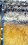
Typically the surface layer is dark gray sand about 6 inches thick. The subsoil is about 20 inches thick. The upper 14 inches of the subsoil is brown and yellowish brown, loose loamy sand; the lower 6 inches is yellowish brown, loose sand. The substratum is light yellowish brown sand to a depth of 60 inches or more.
Included with this soil in mapping are small areas of Udipsamments, rolling, and Katama, Klej, and Riverhead soils. Also included are areas of wind-deposited sand from nearby sand dunes and a few areas of soils that have slopes of more than 3 percent. Included soils make up about 15 percent of this unit.
The permeability of this soil is rapid in the surface layer and subsoil and very rapid in the substratum. Available water capacity is low.
Many areas of this soil are covered with native grass, and some areas are idle land that was once pastured. A few areas are covered with woody plants. The soil is poorly suited to openland wildlife habitat or woodland wildlife habitat but is well suited to most other nonfarm uses.
Drought and soil blowing make this soil poorly suited to crops, hay, or pasture. Irrigation helps to overcome the drought limitation, and maintaining a plant cover and using crop residue help prevent soil blowing.
This Evesboro soil has essentially no limitations as a site for buildings or for local roads and streets; however, the sides of excavations in this soil are unstable and steep excavations commonly collapse. The soil has few limitations for septic tank absorption fields, but seepage of the effluent through the substratum causes a hazard of ground-water contamination.
Capability subclass VIIs.
EvB-Evesboro sand, 3 to 8 percent slopes. This gently sloping, excessively drained soil is in irregularly shaped areas that range from 20 to 300 acres. Slopes are smooth and are commonly 500 to 1,000 feet long.
Typically, the surface layer is dark gray sand about 6 inches thick. The subsoil is about 20 inches thick. The upper 14 inches of the subsoil is brown and yellowish brown, loose loamy sand; the lower 6 inches is yellowish brown, loose sand. The substratum is light yellowish brown sand to a depth of 60 inches or more.
Included with this soil in mapping are small areas of Udipsamments, rolling, and Klej and Riverhead soils. Also included are areas of wind-deposited sand from nearby sand dunes and a few areas of soils that have slopes of less than 3 percent or more than 8 percent. Included soils make up about 15 percent of this unit.
The permeability of this soil is rapid in the surface layer and subsoil and very rapid in the substratum. Available water capacity is low.
Many areas of this soil are covered with native grass, and some areas are idle land that was once pastured. A few areas are covered with woody plants. The soil is poorly suited to openland wildlife habitat and woodland wildlife habitat. It is well suited to most other nonfarm uses.
Drought and soil blowing make this soil poorly suited to crops, hay, or pasture. Irrigation helps overcome the drought limitation, and maintaining a plant cover helps prevent soil blowing.
This Evesboro soil has essentially no limitations as a site for buildings or for local roads and streets; however, the sides of excavations in this soil are unstable and steep excavations commonly collapse. The soil has few limitations for septic tank absorption fields, but seepage of the effluent through the substratum causes a hazard of ground-water contamination.
Capability subclass VIIs.
EvC-Evesboro sand, 8 to 15 percent slopes. This moderately sloping, excessively drained soil is in irregularly shaped areas that range from 20 to 140 acres. Slopes are convex or concave and are 100 to 500 feet long.
Typically, the surface layer is dark gray sand about 5 inches thick. The subsoil is about 20 inches thick. The upper 14 inches of the subsoil is brown and yellowish brown, loose loamy sand; the lower 6 inches is yellowish brown, loose sand. The substratum is light yellowish brown sand to a depth of 60 inches or more.
Included with this soil in mapping are small areas of Udipsamments, rolling, and Klej and Riverhead soils. Also included are small areas of wind-deposited sand from nearby sand dunes. Included soils make up about 15 percent of this unit.
The permeability of this soil is rapid in the surface layer and subsoil and very rapid in the substratum. Available water capacity is low.
Many areas of this soil are covered with native grass, and some areas are idle land that was once pastured. A few areas are covered with woody plants. The soil is poorly suited to openland wildlife habitat and woodland wildlife habitat. It is suitable for most other nonfarm uses.
Drought and soil blowing make this soil poorly suited to crops, hay, or pasture. Maintaining a plant cover helps prevent soil blowing.
Slope is the main limitation of this soil for most urban and nonfarm uses. Building sites need reshaping or special design to overcome the slope limitation. Sides of excavations in this soil are unstable, and the steeper excavations commonly collapse. Roads and streets need to be designed to reduce steep grades and to avoid deep cuts on which a plant cover is difficult to maintain. Placing absorption fields on the contour helps reduce seepage at the base of the slope, but seepage of the effluent through the substratum causes a hazard of ground-water contamination.
Capability subclass VIIs.
ExB-Evesboro sand, 3 to 8 percent slopes, overblown. This gently sloping, excessively drained soil is in an irregularly shaped area. Slopes are smooth and range from 200 to 1,000 feet long.
Typically, the surface layer is wind-deposited very dark gray and gray sand 18 inches thick. The next layer is dark gray sand about 6 inches thick. The subsoil is about 18 inches thick. It is dark brown loamy sand in the upper part and yellowish brown sand in the lower part. The substratum is light yellowish brown sand to a depth of 60 inches or more.
Included with this soil in mapping are small areas of Udipsamments, rolling; Evesboro sand, 3 to 8 percent slopes; and Plymouth and Riverhead soils. Also included are areas of soils that have slopes of less than 3 percent or more than 8 percent. Included soils make up about 15 percent of this unit.
The permeability of this soil is rapid above the substratum and very rapid in the substratum. Available water capacity is low.
Most areas of this soil are covered with sparse native grass. The soil is poorly suited to openland wildlife habitat or woodland wildlife habitat but is suitable for most other nonfarm uses.
Drought and soil blowing make this soil poorly suited to crops, hay, or pasture. Maintaining a plant cover helps prevent soil blowing.
This Evesboro soil has essentially no limitations as a site for buildings or for local roads and streets; however, the sides of excavations in this soil are unstable and steep excavations commonly collapse. The soil has few limitations for septic tank absorption fields, but seepage of the effluent through the substratum causes a hazard of ground-water contamination.
Capability subclass VIIs.