Soil Map Unit Description from the Soil Survey of Rhode Island
Click here for more information about Birchwood Soils
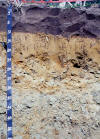
Bc—Birchwood sandy loam. This nearly level, moderately well drained soil is on the crests of upland hills and drumlins and in transitional positions between up lands and outwash terraces. Areas are irregular in shape and mostly range from 6 to 30 acres. Slopes range from 0 to 3 percent.
Typically the surface layer is dark brown sandy loam about 10 inches thick. The subsoil is 14 inches thick. It is yellowish brown loamy sand that is mottled in the lower part. The substratum is very firm, black gravelly sandy loam to a depth of 60 inches or more.
Included with this soil in mapping are small areas of well drained Poquonock, Newport, and Paxton soils; moderately well drained Woodbridge and Pittstown soils; and poorly drained Stissing soils. Also included are small areas of soils that have slopes of more than 3 percent. Included areas make up about 10 percent of this map unit.
The permeability of this soil is moderately rapid in the surface layer, rapid in the subsoil, and slow or very slow in the substratum. Available water capacity is low, and runoff is slow. This soil has a seasonal high water table at a depth of about 20 inches from late fall through midspring. The soil is very strongly acid through medium acid.
Wetness and the slow or very slow permeability of the substratum limit this soil for community development. Onsite septic systems need special design and installation, If suitable outlets are available, subsurface drains help prevent wet basements. Lawn grasses, shallow- rooted trees, and shrubs require watering in summer. Roads and streets on this soil need special design to prevent frost heaving.
Many areas of this soil are farmed, a use to which it is suited. Wetness is the main limitation. The soil dries out and warms up slowly in the spring, and artificial drainage is needed, but irrigation is necessary in dry seasons. The use of cover crops and the return of crop residue to the soil help to maintain tilth and organic matter content.
This soil is suited to trees, woodland wildlife habitat, and openland wildlife habitat. It is too dry to provide wetland wildlife habitat. Capability subclass IIw; wood land group 4o.
Back to Rhode
Island Soil Survey
Back to Nesoil.com