George Demas
Subaqueous and Submerged Soil Fact Sheet
by Jim Turenne
Subaqueous soil slide show
(PDF)
Introduction to Subaqueous soils - Mike Bradley
Rhode Island Mapping Partnership for Coastal Soil and Sediment
Click here for Ninigret Pond Point Data Example
Introduction:
The study of subaqueous soils is a relatively new field in Pedology or soil science. The concept that sediments in shallow water environments undergo soil forming processes, are capable of supporting rooted plants, and meet the definition of soil according to the criteria defined in Soil Taxonomy has been moving soil scientists into a new frontier of soil survey – mapping subaqueous soils.
The National Cooperative Soil Survey (NCSS) is a nationwide partnership of Federal, regional, State, and local agencies and institutions. This partnership works together to cooperatively investigate, inventory, document, classify, and interpret soils and to disseminate, publish, and promote the use of information about the soils of the United States and its trust territories. The activities of the NCSS are carried out on National, regional, and State levels.
The USDA, Natural Resources Conservation Service (NRCS) is the lead federal agency for the mapping and interpretations of the nation’s soil resource and the extension of soil survey technology to global applications.
Subaqueous and Submerged Soils:
As the name implies, subaqueous and submerged soils are soils that occur under water (both fresh and salt water). The depth range of the water column where these soils may be found is not know, an arbitrary depth of 2.5 meters below the surface has been set for soil survey inventory. The difference between subaqueous and submerged soils is that submerged soils became submerged as a result of rising water tables, flooding events (such as a Beaver Dam), or sea level rise. Submerged soils formed in an upland environment but are now underwater. Subaqueous soils formed under a continuous water column (such as in an estuary), although their sediments may have originated from an upland area such as a dune.
Although proposals to include permanently submersed sediments as soil have been put forth since the mid 1800’s, it was not until the early 1990’s that the concept of subaqueous soils was developed in the U.S. The pioneer in U.S. subaqueous soils is the late George Demas, a soil scientist working for the National Cooperative Soil Survey in the Chesapeake Bay region of Maryland. George observed that subaqueous areas met the definition of soil by being able to support rooted plant growth (such as Eel Grass) and had formed soil horizons. Further study revealed that these submersed sediments underwent other soil forming (pedogenic) properties including additions, losses, and transformations of energy and matter.
George Demas
Significance of Subaqueous Soils:
A major limitation to science-based management of shallow water habitats has been a lack of definitive information on the properties and spatial distribution of subaqueous soils. In part, this lack of information has stemmed from an inadequate paradigm for subaqueous soils, which has not considered them “soils” at all, but rather as “sediments”. During the decade it has been demonstrated that these “sediments” would be better understood as “soils” and that the sedimentary paradigm should give way to a pedological paradigm.
An advantage of using the pedological approach to study shallow water habitat is that soils are studied as a collection of horizons that are linked vertically with depth and horizontally across the subaqueous landscape. These horizons are studied and characterized by examining a combination of properties and characteristics, instead of, say, a single component or parameter. In this manner, subaqueous soil can be characterized as ecological map units and provide a site-based system to identify the geomorphic settings that represent the subaqueous landscape. The following are some advantages of a subaqueous soil approach to shallow water classification:
Subaqueous Soil Survey:
Several States throughout the U.S. have begun the process of mapping and inventorying subaqueous soils. States with subaqueous soils are responsible for determining the activity in their State related to subaqueous soil mapping.
How are subaqueous soils mapped?
Traditional terrestrial soil mapping is conducted by a field soil scientist trained to understand the interaction of soil forming processes and soil-landscape relations. Mapping soil involves mostly field work with the soil mapper traversing the landscape and digging many holes to observe the soil condition and classify the soil. Subaqueous soil mapping is performed in much the same way, except the mapper is in water. Instead of topographic maps to provide landscape position, subaqueous soil mapping uses bathymetric maps to identify landscapes and landforms. Shovels are replaced with augers and special tools, such as peat corers and vibracore, to obtain the soil samples.
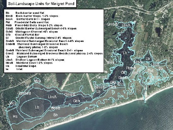
An example of a subaqueous soil landscape unit map (click to
link to descriptions)
Uses of Subaqueous Soil Mapping:
A major use of traditional soils surveys is to provide interpretation for various land uses and environmental planning. Interpretations for subaqueous soils are currently being developed for a variety of uses. As more areas are surveyed and more data collected a wide array of soil interpretations are expected. The following is a brief list of some uses of subaqueous soil survey data.
|
• SAV Restoration • Crab Habitat • Clam Stocking • Management for Sustainable Production Clam, Oyster, and Scallop • Nutrient Reduction • Pathogens Pfesteria Cyst Residence Sites • Benthic Preservation Site Identification • Wildlife Management • Wading Shore Birds, Migratory Waterfowl, Nurseries and Spawning Areas • Habitat Protection for Horseshoe Crab and Diamondback Terrapin |
• Effects of Dredging on Benthic Ecology • Off Site Disposal of Dredge Spoil • Acid-Sulfate Weathering Hazards • Dune Maintenance/Replenishment • Resource inventory • Baseline conditions • Dredging considerations • Resource remediation • Aquaculture |
For more information on subaqueous soils visit: http://www.mapcoast.org
Introduction to Subaqueous Soils:
By Mike
Bradley
Recently, the USDA-Natural Resources Conservation Service (NRCS) established that sediment in shallow water may be considered soil. With MapCoast (www.mapcoast.org), the NRCS strives to map subaqueous soil areas in Rhode Island. Estuarine subaqueous soils are permanently flooded soils that occur immediately below the intertidal zone to shallow water depths (generally <5 m) in protected coves, bays, inlets, and in back-barrier coastal lagoons. This new designation is the result of work in Maryland in which estuarine substrates in shallow water were shown to undergo soil forming (pedogenic) processes. Processes operating in subaqueous soils include additions of biogenic CaCO3 and marine humus from benthic biota, bioturbation from shellfish and worms, and chemical transformation of sulfur and iron in anoxic environments; all of which differentiate surficial sediment into soil horizons.
The correlations between shallow water estuarine sediment and the classic tenets of soil formation support the inclusion of these substrates within the realm of soil science (Pedology). One of the principle components of the definition of terrestrial soils is the ability to support rooted plants in a natural environment. Dense beds of submerged aquatic vegetation (SAV, or seagrass) are often found in subtidal estuaries. Unlike macro-algal species, which anchor themselves to a substrate, SAV species are rooted vascular aquatic plants in which roots serve both structural and nutrient uptake purposes. A highly diverse benthic faunal community also depends on subaqueous soils for nutrients, structure, and habitat. The actions of these marine animals are similar to those inhabiting terrestrial soils. Marine animals mix grain sizes, diffuse oxygen to the subsurface layers, decompose organic matter, and concomitantly supply organic carbon from decaying organisms, fecal pellets, and excretion of mucus. Finally, numerous studies have emphasized the importance of landscape components for predicting and explaining soil distributions. Submerged landscapes are fundamentally the same as terrestrial systems and have a discernable topography from which subaqueous landforms and landscape units may be identified
Considerable research has focused on many components of estuarine and coastal ecosystems including hydrology, vegetation and floral and faunal interactions. However, the substrate, which supports a wide variety of benthic invertebrates and supports dense areas of SAV, has been largely ignored. Geologic studies have focused on this realm of the ecosystem, but the information provided by these studies is not detailed enough to be of ecological significance and most of these studies focused on a single parameter (e.g. grain size). An advantage of using the soil science approach to study shallow water sediments is that soils are studied as a collection of horizons that are linked with depth across the landscape. These horizons are studied and characterized by examining a combination of properties and characteristics, instead of a single component or parameter. As such, the NRCS, along with MapCoast partners, recognize the need for a new model of mapping shallow water substrates that incorporates traditional soil survey methods along with established geologic oceanography techniques.
Back to Nesoil Subaqueous Soil Page