Soil Survey of Bristol County, Massachusetts
SOUTHERN PART
The following Map Unit Description is from the 1981 Soil Survey of Bristol County, Southern Part. Please note: map unit symbols are DIFFERENT for Bristol South and Bristol North reports, do NOT use these descriptions for Bristol North.
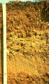 Profile of a
Hinckley soil
Profile of a
Hinckley soilHgA-Hinckley gravelly fine sandy loam, 0 to 3 percent slopes. This soil is nearly level, deep, and excessively drained. It is near large streams and rivers. Areas of this soil are irregular in shape and range from 5 to 150 acres. Most are about 30 acres.
Typically, the surface layer is dark brown gravelly fine sandy loam about 6 inches thick. The subsoil is 14 inches thick. The upper 3 inches of the subsoil is yellowish brown, very friable gravelly fine sandy loam, and the lower 11 inches is light olive brown gravelly loamy coarse sand. The substratum is light olive brown very gravelly coarse sand to a depth of 60 inches or more.
Included with this soil in mapping are small areas of Deerfield, Merrimac, and Windsor soils. In some places this unit is bounded by short, steep slopes. Included areas make up about 20 percent of the unit.
The permeability of this Hinckley soil is rapid in the surface layer and subsoil and very rapid in the substratum. Available water capacity is very low. The surface layer of this soil is very friable and easily tilled. Root growth is restricted to a depth of about 20 inches by the loose sand and gravel. This soil is droughty in late summer.
Most areas of this soil are in woodland. Some areas are used for homesites and other types of community development, and some areas are farmed.
This soil is suited to row crops, but droughtiness makes irrigation necessary in most years. The main management practices include using cover crops and incorporating crop residue and manure into the surface layer.
This soil is suited to hay and pasture, especially to drought-resistant plants. The main management concern is the prevention of overgrazing. Using proper stocking rates help's to maintain plant densities and desirable species.
The soil is suited to trees, but droughtiness causes a high rate of seedling mortality. Reducing plant competition and planting. drought-resistant tree species help to reduce seedling mortality.
The rapid permeability is the main limitation of this soil for community development, especially as a site for septic tank absorption fields and sanitary landfills. The permeability causes a hazard of groundwater pollution in areas used for landfills or septic tanks. The soil is a potential source of sand and gravel.
Capability subclass: IIIs.
HgB-Hinckley gravelly fine sandy loam, 3 to 8 percent slopes. This soil is gently sloping, deep, and excessivley drained. It is near large streams and rivers. Areas of this soil are irregular in shape and range from 5 to 150 acres. Most are about 30 acres.
Typically, the surface layer is dark brown gravelly fine sandy loam about 6 inches thick (fig. 5). The subsoil is 14 inches thick. The upper 3 inches of the subsoil is yellowish brown gravelly fine sandy loam, and the lower 11 inches is light olive brown gravelly loamy coarse sand. The substratum is light olive brown very gravelly coarse sand to a depth of 60 inches or more.
Included with this soil in mapping are small areas of Deerfield, Merrimac, and Windsor soils. In some places this unit is bounded by short, steep slopes. Included areas make up about 20 percent of this unit.
The permeability of this Hinckley soil is rapid in the surface layer and subsoil and very rapid in the substratum. Available water capacity is very low. The surface layer of this soil is very friable and easily tilled. Root growth is restricted to a depth of about 20 inches by the loose sand and gravel. This soil is droughty in late summer.
Most areas of this soil are in woodland. Some areas are used for homesites and other types of community development, and some areas are farmed.
This soil is suited to row crops, but droughtiness makes irrigation necessary in most years. Erosion is a hazard. Using cover crops and incorporating crop residue and manure into the surface layer help to control erosion.
The soil is suited to hay and pasture, especially to drought-resistant plants. The main management concern is the prevention of overgrazing. Using proper stocking rates helps to maintain plant densities and desirable species.
This soil is suited to trees, but droughtiness causes a high rate of seedling mortality. Reducing plant competition and planting drought-resistant tree species help to reduce seedling mortality.
The rapid permeability is the main limitation of this soil for community development, especially as a site for septic tank absorption fields and sanitary landfills. The permeability causes a hazard of ground-water pollution in areas used for landfills or septic tanks. The soil is a potential source of sand and gravel.
Capability subclass: IIIs.
HgC-Hinckley gravelly fine sandy loam, 8 to 15 percent slopes. This soil is moderately sloping, deep, and excessively drained. It is near large streams and rivers. Areas of this soil are irregular in shape and range from 5 to 150 acres. Most are about 30 acres.
Typically, the surface layer is dark brown gravelly fine sandy loam about 2 inches thick. The subsoil is 18 inches thick. The upper 7 inches of the subsoil is yellowish brown gravelly loamy coarse sand, and the lower 1 1 inches is light olive brown gravelly loamy coarse sand. The substratum is light olive brown very gravelly coarse sand to a depth of 60 inches or more.
Included with this soil in mapping are small areas of Merrimac, Wareham, and Windsor soils. Also included are areas where stones and boulders cover up to 3 percent of the surface, areas with slopes of 3 to 8 percent, and areas with slopes of 15 to 25 percent. Included areas make up about 20 percent of the unit.
The permeability of this Hinckley soil is rapid in the surface layer and subsoil and very rapid in the substratum. Available water capacity is very low. The surface layer of this soil is very friable and easily tilled. Root growth is restricted to a depth of about 20 inches by loose sand and gravel. This soil is droughty in late summer.
Most areas of this soil are in woodland. Some areas are used for homesites and other types of community development.
Droughtiness, slope, and an erosion hazard make this soil poorly suited to row crops. The soil is suited to hay and pasture, but drought-resistant plants are needed. The main pasture management concern is the prevention of overgrazing. Using proper stocking rates helps to maintain plant densities and desirable species.
This soil is suited to trees, but droughtiness causes a high rate of seedling mortality. Reducing plant competition and planting drought-resistant species help to reduce seedling mortality.
Slope and the rapid permeability of the soil are the main limitations for community development. Slope limits the soil as a building site. The permeability causes a hazard of ground-water pollution in areas used for landfills or septic tanks. The soil is a potential source of sand and gravel.
Capability subclass: IVs.
HgD-Hinckley gravelly fine sandy loam, 15 to 25 percent slopes. This soil is moderately steep, deep, and excessively drained. It is adjacent to or near large streams and rivers. Areas of this soil are irregular in shape and range from 1 0 to 150 acres. Most are about 30 acres.
Typically, the surface layer is dark brown gravelly fine sandy loam about 2 inches thick. The subsoil is 18 inches thick. The upper 7 inches of the subsoil is yellowish brown gravelly fine sandy loam, and the lower 1 1 inches is light olive brown gravelly loamy coarse sand. The substratum is light olive brown very gravelly coarse sand to a depth of 60 inches or more.
Included with this soil in mapping are small areas of Merrimac, Wareham, and Windsor soils. Also included are areas with slopes of 8 to 15 percent and areas with slopes of 25 to 35 percent slopes. Included areas make up about 20 percent of the unit.
The permeability of this Hinckley soil is rapid in the surface layer and subsoil and very rapid in the substratum. Available water capacity is very low. The surface layer of this soil is very friable. Root growth is restricted to a depth of about 20 inches by the loose sand and gravel. The soil is droughty in late summer.
Most areas of this soil are in woodland. Some areas are used for homesites or other types of community development.
Droughtiness, slope, and an erosion hazard make this soil poorly suited to farming.
The soil is suited to trees, but droughtiness causes a high rate of seedling mortality and slope limits the use of harvesting equipment. Planting drought-resistant tree species and reducing plant competition help to reduce seedling mortality.
Slope is the main limitation of this soil for most types of community development, including use as a building site or as a site for sanitary landfills or septic tank absorption fields. The permeability of the soil causes a hazard of ground-water pollution in areas used for septic tanks or landfills. The soil is a potential source of sand and gravel.
Capability subclass: VIs.
More Information on Hinckley Soils | Hinckley Official Series Description