Soil Survey of Bristol County, Massachusetts
SOUTHERN PART
The following Map Unit Description is from the 1981 Soil Survey of Bristol County, Southern Part. Please note: map unit symbols are DIFFERENT for Bristol South and Bristol North reports, do NOT use these descriptions for Bristol North.
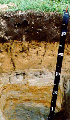 Sudbury Profile
SdA-Sudbury fine sandy loam, 0 to 3 percent slopes. This soil is nearly level, deep, and moderately well drained. It is near or adjacent to streams and rivers. Areas of this soil are irregular in shape and range from 5 to 40 acres. Most are about 10 acres.
Typically, the surface layer is black fine sandy loam about 2 inches thick. The subsurface layer is grayish brown sandy loam 2 inches thick. The subsoil is brown and is 24 inches thick. The upper 14 inches of the subsoil is fine sandy loam, and the lower 10 inches is mottled gravelly coarse sandy loam. The substratum is light olive brown, mottled gravelly coarse sand to a depth of 60 inches or more.
Included with this soil in mapping are convex areas of Merrimac soils on rises and areas of Walpole soils in depressions. Also included are small areas of Deerfield and Ninigret soils and a few areas of gently sloping soils. Included areas make up about 20 percent of the unit.
The permeability of this Sudbury soil is moderately rapid in the surface layer and upper part of the subsoil, moderately rapid or rapid in the lower part of the subsoil, and rapid in the substratum. Available water capacity is moderate. A seasonal high water table is within 3 feet of the surface in the winter and spring and after periods of heavy rain. The surface layer of this soil is very friable and easily tilled. Root development is restricted to a depth of about 28 inches by loose sand and gravel.
Most areas of this soil are in woodland, and the soil is suited to trees. A few areas are farmed. A few are used for homesites and other types of community development.
This soil is suited to row crops. The seasonal high water table is the main limitation. The main management practices include using drainage, using cover crops, and incorporating crop residue and manure into the surface layer to maintain the organic matter content.
The soil is suited to hay and pasture. The main management concerns are the prevention of overgrazing, the prevention of grazing when the soil is wet, and avoiding the use of equipment when the soil is wet, all of which reduce the hardiness and density of plants and cause surface compaction.
The seasonal high water table is the main limitation of the soil for community development, especially as a building site or as a site for septic tank absorption fields or sanitary landfills. The rapid permeability in the substratum causes a hazard of ground-water pollution in areas used for septic tanks or landfills.
Capability subclass: IIw.
SdB-Sudbury fine sandy loam, 3 to 8 percent slopes. This soil is gently sloping, deep, and moderately well drained. It is near or adjacent to streams and rivers. Areas of this soil are irregular in shape and range from 5 to 40 acres. Most are about 10 acres.
Typically, the surface layer is black fine sandy loam about 2 inches thick. The subsurface layer is grayish brown sandy loam 2 inches thick. The subsoil is brown and is 24 inches thick. The upper 14 inches of the subsoil is fine sandy loam, and the lower 10 inches is mottled gravelly coarse sandy loam. The substratum is light olive brown, mottled gravelly coarse sand to a depth of 60 inches or more.
Included with this soil in mapping are convex areas of Merrimac soils on rises and areas of Walpole soils in depressions. Also included are small areas of Deerfield and Ninigret soils and a few areas of nearly level soils. Included areas make up about 20 percent of the unit.
The permeability of this Sudbury soil is moderately rapid in the surface layer and upper part of the subsoil, moderately rapid or rapid in the lower part of the subsoil, and rapid in the substratum. Available water capacity is moderate. A seasonal high water table is within 3 feet of the surface in the winter and spring and after periods of heavy rain. The surface layer of this soil is very friable and easily tilled. Root development is restricted to a depth of about 28 inches by loose sand and gravel.
Most areas of this soil are in woodland, and the soil is suited to trees. A few areas are farmed. Some areas are used for homesites and other types of community development.
This soil is suited to row crops. The seasonal high water table is the main limitation, and erosion is a hazard. The main management practices include using drainage, using cover crops, and incorporating crop residue and manure into the surface layer to maintain the organic matter content.
The soil is suited to hay and pasture. The main management concerns are the prevention of overgrazing, the prevention of grazing when the soil is wet, and avoiding the use of equipment when the soil is wet, all of which reduce the hardiness and density of plants and cause surface compaction.
The seasonal high water table is the main limitation of the soil for community development, especially as a building site or as a site for septic tank absorption fields or sanitary landfills. The rapid permeability in the substratum causes a hazard of ground-water pollution in areas used for septic tanks or landfills.
Capability subclass: IIe.