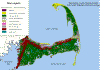
 Barnstable County Parent Materials
Map Created with Digital Soil Data.
Barnstable County Parent Materials
Map Created with Digital Soil Data.Digital Soil Maps Now
Available For Parts of Massachusetts
Digital Soil Data now
available from Web Soil Survey
SEsoil CD Available with Digital Soils Data for
all of Southeastern
Massachusetts
Basic Arc View GIS Concepts - Training
Material for Arc View
Barnstable County Parent Materials
Map Created with Digital Soil Data.
Quick Links to New England GIS Data
| Rhode Island | Massachusetts | Connecticut | |||
| RIGIS Environmental Resource Maps (RI Digital Soil Maps) |
Mass/GIS | Map and Geographic Information Center |
Note: If you do not have a GIS program such as Arc/View, you can download a free program called Arc/Explorer from ESRI to view GIS data.
The Massachusetts USDA-NRCS, working in cooperation with Mass/GIS and the Massachusetts Department of Food and Agriculture are in the process of digitizing published soil surveys in Massachusetts. The digital maps allow soil survey information to be used with a geographic information system (GIS) along with other resource inventory maps and databases.
A geographic information system (GIS) is a computer system capable of assembling, storing, manipulating, and displaying geographically referenced information (i.e. spatial data). This system should include hardware, software, data and staff. Geographic information systems belong to a family of mapping and drafting programs that includes computer-aided design (CAD) and automated mapping and facilities management (AM/FM). GIS is distinguished from CAD and AM/FM by its capacity to perform complicated analytical functions that often include combining information from different sources to derive meaningful relationships.
Mass/GIS Soil Data: MassGIS Soil Data download site
Digital soil survey information for Massachusetts is available for download from Mass/GIS (click here to go to the Mass/GIS soil data layer description). The Counties of Barnstable, Bristol, Berkshire, Dukes, Essex, Hampden, Hampshire, Nantucket, Norfolk, and Suffolk are currently (December 2003) digitized. The soil coverages are in Massachusetts State Plane, NAD 83 projection. Other counties should be available soon. The goal is to have complete digital soil surveys for Massachusetts. Status of Massachusetts Digital Soil Data
Link to Digital Soil Download Site: http://soildatamart.nrcs.usda.gov/
Digital soil surveys authorized for release by the USDA-NRCS must undergo a certification process to ensure quality control and accuracy, this certification is called the Soil Survey Geographic Data Base (SSURGO). Mapping scales generally range from 1:12,000 to 1:63,360; SSURGO is the most detailed level of soil mapping done by the Natural Resources Conservation Service (NRCS). SSURGO digitizing duplicates the original soil survey maps. This level of mapping is designed for use by landowners, townships, and county natural resource planning and management. The user should be knowledgeable of soils data and their characteristics. For information on downloading the soil maps from the USDA-NRCS visit the Soil Data Mart.
MAP/GIS Links
Earth Science
Information Office, University of Massachusetts (Cartographic
Information Service)
General
Soil Maps for Plymouth County Massachusetts
Geography Network
Historic
USGS Maps of New England
Maptech Map Server
(topos, nautical charts)
Maps
and References (Links to all types of maps)
Massachusetts
Geographic Information System
The National
Atlas of the United States of America
Rhode Island GIS
RI MIT Ortho
Server
Topo Zone - USGS
topographic maps anywhere in the U.S.
USDA:NRCS:Geospatial
Data Gateway - Lighthouse Project -Digital Soil Data
USGS National Mapping
Information Home Page
Wetlands
Interactive Mapping Tool (USFWS-NWI Maps)