NOTE: A CD HAS BEEN PREPARED THAT HAS THE DIGITAL SOILS DATA AND OTHER DATA FOR SE MASS. SEND AND EMAIL FOR MORE INFORMATION.
NOTE: All information contained within this document is advance information, subject to change. Please contact Jim Turenne if you need more information: 401-822-8830 or jimturenne@gmail.com.
Soil Attribute Join Table for Southeastern Mass/GIS Digital Soil Data
Introduction
Directions
Making soil intpertetive maps
Using the Hot Link script
Explanations of Soil Join
Table Fields
The barnsoil.dbf and norfsoil.dbf files contain soil attribute information designed to provide interpretive maps for digitized soil surveys for SE Mass. The database files contain a common field called "MAPUNIT" which can be joined to the "Stateleg" field of the soil attribute table. The joining of the two tables allows the user to produce soil interpretive maps showing various soil properties such as hydric soil areas, suitability for on-site septic systems and hydrologic groups. The following explains the procedure for joining the two tables along with descriptions on each field for creating the interpretive maps.
To use the files contained in this program extract the zip file into a directory of your choice, remember to keep track of where you download and extract your files (it's good practice to develop a file naming structure).
As of July 2001 digital soil survey information is available for Barnstable, Norfolk, and Suffolk Counties. There are two ways of getting the digital soil information for use with a GIS program. One source is from the USDA Soil Survey Geographic (SSURGO) Database (see: http://nesoil.com/gis/ssurgoinstructions.html for directions how to download from the clearinghouse site). Another way is to get digital soil data is from Mass/GIS (I recommend getting it from this source so you will be able to use with other data from Massachusetts). Soil data from Mass/GIS is available by USGS Quadrangle and is projected in Massachusetts State Plane, NAD 83 coordinates, go to: http://www.state.ma.us/mgis/soi.htm for the soil data layer description.
Mass/GIS Digital Soil Data:
There are two soil layers available for download from Mass/GIS
- Soil Features and Spot Features (read the datalayer
description completely). The soil features are the soil polygons
(soil map) and soil attribute information. The spot features
layer has the ad-hoc spot symbols placed on the soil maps. These
spot symbols show the location of various features such as wet
spots, marshes, and bedrock outcrops the soil mapper identified
in the field during the production of the maps. The spot symbols
were used in areas that were too small (less than 5-8 acres) to
delineate at the scale of mapping. It is important to download
both features. If you want the entire County in an Arc/View
shape file contact me at 508-295-5151 x2.
After downloading both features for the quadrangle, extract
the EXE files into a directory.
You should get a number of Arc/View files (*.shp, *.dbf, *.shx,
etc.) in your directory for each layer.
Using the join table (extract the join table and associated files into a directory):
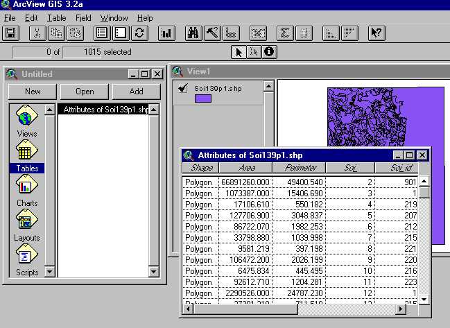
1. With Arc/View running and a "View"open click the "Add Theme" button and navigate to the folder you extracted the soil shape file to, click the shape file with the "p" after the feature name such as SOI170p1.shp.
2. Make the soil theme active (click on the theme name in the
view's table of content - it should have a raised appearance) and
open the attribute table by clicking the ![]() button.
button.
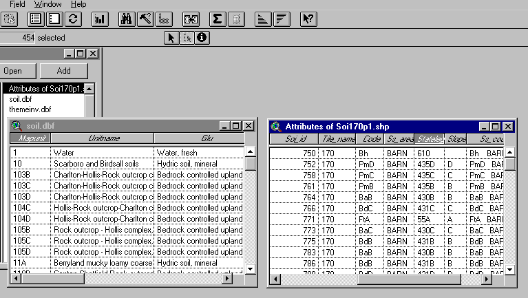
3. Minimize the view window and go to the document types window (see figure below). Click the "Tables" document type then select the "Add" button. Under the "List Files of Type" dropdown menu, select "dbase" and navigate to the folder you put the join table files into. Click the join table for the County you are working in (Norfolk/Suffolk are in norfsoil.dbf, Barnstable County is in barnsoil.dbf) to open it.
4. Click the "Mapunit" field of the barnsoil.dbf
or norfsoil.dbf table FIRST, then click the "Stateleg"
field of the soil attribute table (Attributes of Soi##.shp). Now
click the "Join Table" ![]() button. This should join the soil.dbf
table to the soil attribute table (you should see the fields from
the soil.dbf table added to the Attribute of Soi##.shp table).
button. This should join the soil.dbf
table to the soil attribute table (you should see the fields from
the soil.dbf table added to the Attribute of Soi##.shp table).
5. Open the "view" document type window and try creating a theme map.
Making soil intpertetive maps:
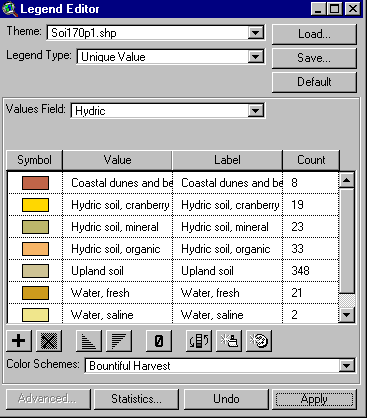
Double click the SOIXXp1.shp file to open the legend editor. In the "Legend Type" box select "Unique Value", in the "Values Field" navigate to the field you want to create as shown below (explanations of each field is provided below):
You may want to edit the symbols to suit your needs. Some fields such as "Onsew" for onsite sewage maps have a legend file (*.avl) created (not yet available) click the load button and navigate to the onsew.avl file.
The Link_URL.ave script included allows you use Arc/View's
"Hot Link" ![]() button to link the soil polygons to the map unit
descriptions found in the published soil surveys via the Internet.
To use this feature you must have your computer connected to the
Internet. The join table has a field called "URL" that
provides the URL to the map unit description. To use this feature,
follow these instructions:
button to link the soil polygons to the map unit
descriptions found in the published soil surveys via the Internet.
To use this feature you must have your computer connected to the
Internet. The join table has a field called "URL" that
provides the URL to the map unit description. To use this feature,
follow these instructions:
Explanations of Soil Join Table Fields:
NOTE: UNC means the field is not classified refer to map unit description for more information. Some of the field names may be different depending on which version you have.
ESWT = Estimated Depth to Seasonal High Watertable (Click for more information)
MAPUNIT
UNITNAME
DESCRIPT: Quick soil description
ONSEW: Onsite Sewage Disposal
HYDRIC: Hydric Soils
AGRIC: Agricultural Interpretation
GEOLOGIC (Soil Parent Material)
HYDGRP: Hydrologic Groups
URL
SURFTEX: Surface Texture
FROST: Frost Action
DRAINAGE: Soil Drainage Class
HYDRICYN: Hydric soil, yes or no
CORCON and CORSTEEL: Risk of
corrosion, steel and concrete
CAPCLAS and SUBCLAS: Capability
Class and Subclass
MAPUNIT: This field contains the alpha and or alphnumeric map unit symbol used to join with the STATELEG filed of the soil attribute table. The numbers are the soil map units used on our state-wide soil legend.
UNITNAME: This field has the soil map unit name from the published soil survey .
This field lists a brief description of the soil map unit, grouping properties such as depth to watertable, drainage, and other features. The following table describes the fields and provides some information about development potential/limitations:
| Field Name | Description |
| Bedrock Controlled Uplands. | Areas with a shallow depth
to bedrock soils and rock outcrops. Generally poorly suited for development due to shallow soil depth. |
| Coastal dunes and beaches. | Groups both vegetated and
non-vegetated dunes and coastal soils. Very poorly suited to development due to severe erosion. |
| ESHWT > 4.0 feet, rapid
permeability. (NOTE: These depths to ESWT may not be the same depth listed in the published soil survey tables, see the report for ESWT depth ranges). |
Soils with depth to seasonal
high watertable (ESWT) greater than 5 feet below the
surface and rapid permeability substratum. Generally suited for development, BUT also associated with aquifer recharge areas. |
| ESHWT > 4.0 feet, slow
permeability. (NOTE: These depths to ESWT may not be the same depth listed in the published soil survey tables, see the report for ESWT depth ranges). |
Soils with depth to
watertable greater than 5 feet below the surface and slow
permeability substratum. Generally suited for development, poorly suited to onsite septic systems. |
| ESHWT 1.5 to 4.0 feet, rapid
permeability. (NOTE: These depths to ESWT may not be the same depth listed in the published soil survey tables, see the report for ESWT depth ranges). |
Soils with depth to APPARENT
watertable between 1.5 to 4 feet below the surface. Generally moderate constraints to development, subsurface drains are needed and mounded septic systems. Associated with aquifer recharge areas. |
| ESHWT 1.5 to 4.0 feet, slow
permeability. (NOTE: These depths to ESWT may not be the same depth listed in the published soil survey tables, see the report for ESWT depth ranges). |
Soils with depth to PERCHED
watertable between 1.5 to 4 feet below the surface. Generally moderate constraints to development, subsurface drains are needed and mounded septic systems. Slowly pervious layer may restrict septic systems. |
| Floodplain soils. | Soils in modern-day
floodplains, subject to inundation by flooding. Very poorly suited to development due to flooding. |
| Human Altered, cuts and fills. | Areas altered by human
activity. Includes areas of fill and areas cut down to
the geologic deposits. Variable soil conditions, onsite investigations needed to determine development potential. |
| Hydric soils. | Poorly and very poorly
drained soils associated with wetland areas. Very poorly suited to development due to extreme wetness. |
| Landfills/Dumps. | Areas used for refuse
disposal. Very poorly suited for development due to subsidence and environmental hazards. |
| Water. | Open water bodies including ponds, lakes, rivers, reservoirs and oceans. |
This rating is designed to show soil ability to deliver household sewage effluent into the soil under the State (Massachusetts) Environmental Code Title V: Minimum Requirements for the Subsurface Disposal of Sanitary Sewage (310 CMR 15.00). The interpretive groups are developed to provide general site characteristics for soil requirements.
This information is intended for general planning purposes only and is not, in any way, intended to replace or supercede an on-site investigation. On-site investigations for siting septic systems by certified soil evaluators are required by Title V.
These classes are designed for the installation of new septic systems for new single-family residences and do not apply to large systems or commercial/industrial systems. These classes are only designed for the soils mapped in Southeastern Massachusetts.
The general requirements relating to soil suitability for onsite sewage disposal systems in Massachusetts are;
Based on this criteria, the onsite sewage disposal classes were developed by grouping soil properties such as depth to seasonal high watertable, permeability, depth to bedrock, type of parent material, and drainage class together. The following table lists the onsite sewage disposal classes (A through I), a brief description of the class, and the relation to the Massachusetts Title V code for siting onsite septic disposal systems within this type of soil.
On-site Sewage Disposal Class |
Class Description | Massachusetts Title V Relation |
A |
This group consists of soil map units that have a depth to seasonal high water table greater than 60 inches, depth to bedrock is greater than 60 inches, and permeability of the substratum is rapid to very rapid to a depth of 72 inches. | Generally well suited soil for on-site sewage systems. These areas are often associated with aquifer recharge zones. Nitrate reduction systems may be required in some areas. |
B |
This group consists of soil map units that have a depth to seasonal high water table between 1.5 and 60 inches below the surface, depth to bedrock is greater than 60 inches, and permeability of the substratum is rapid to very rapid. | Generally, these areas require a mounded system so the bottom of the leach field is 4 to 5 feet (depending on the percolation rate) above the seasonal high watertable. Some areas may be required to install nitrate reducing alternative systems to protect the aquifer. |
C |
This group consist of soil map units that have an estimated depth to seasonal high water table greater than 60 inches, depth to bedrock is greater than 60 inches, and permeability of the substratum is moderate to very slow within a depth of 72 inches. | These soils generally have a
restrictive layer within 72 inches and on-site
exploration is often required to locate the four feet of
pervious material. Removal of the slowly permeable
material is often needed and suitable fill material needs
to be brought in. The restrictive material is usually dense till, lacustrine silts and clays, human transported fill, or ice contact material. |
D |
This group consist of soil map units that have a depth to seasonal high water table between 1.5 and 60 inches below the surface, depth to bedrock is greater than 60 inches, and permeability of the substratum is moderate to very slow within a depth of 72 inches. | Generally, these areas require mounded systems and extensive on-site exploration to locate the required four feet of pervious material. Removal of the restrictive layer is often required and suitable fill must be brought in to replace the slowly pervious material. |
E |
This group consists of coastal dunes, beaches and alluvial (floodplain) soils, subject to wave, tidal, coastal storm action and flooding by streams and rivers. | These areas are considered velocity zones and floodways under Title V (see 310 CMR 15.213). |
F |
This group consists of areas where the soils are saturated, flooded, or ponded long enough during the growing season to develop anaerobic conditions in the upper part (hydric soils). | Hydric soils are associated with wetland areas and are subject to protection under state and federal laws. Onsite systems on these areas are required to be mounded 4-5 feet above the surface. Organic soils need to have the organic material removed and replaced with suitable fill material. Glacial till and lacustrine soils often have a restrictive layer. |
G |
This group consists of areas that have been altered by human activities such as gravel, till, and quarry pits, human transported fill, and sanitary landfills. Also included are miscellaneous non-soil areas. | On-site investigation is required to determine the extent and type of alteration. Some of these areas have been excavated (cut) down to the soil parent material (un-weathered geologic material), and other areas have had material placed over the original soil area (fill). The Title V code requires four feet of naturally - occurring pervious material for the proposed soil absorption system. |
H |
This group consists of complex areas of very deep to shallow depth to bedrock soils. | On-site investigation is needed to locate the very deep soils to have the required four feet of pervious material. |
I |
Areas covered with more than 75 percent impervious material (pavement, buildings, etc). | These areas are generally sewered, on-site investigations are needed to determine soil conditions. |
Dual classes may be assigned to soil complexes (soil map units consisting of two or more soil types) such as A/B for map unit 478B-Plymouth-Poquonock complex. The first class (A) is the rating for the Plymouth soil component and the second (B) is the rating for Poquonock soils. Complexes that have the same rating are not assigned dual classes (example: map unit 480 Plymouth-Carver complex, both are class A units). For more information about the soil complex read the soil map unit description (use the hot-link feature to access the description).
This theme map shows hydric and non-hydric soil areas. Hydric soils are soils that are saturated, flooded, or ponded long enough during the growing season to develop anaerobic conditions in the upper part. Hydric soils are generally associated with wetlands and are subject to protection under State and Federal laws. Remember; all soil map units may contain inclusions of hydric and non hydric soils, onsite determination is required to delineate wetlands!! Most published soil surveys are mapped at a scale of 1:20,000 to 1:25,000 with minimum delineation's of 5-8 acres in size.
| Coastal dunes and beaches | Generally these are not hydric soils but are protected areas. |
| Hydric soil, cranberry beds | Hydric soil areas used for the production of cranberries. Also includes abandoned cranberry beds. |
| Hydric soil, mineral | Hydric soils formed in less than 16 inches of organic material. |
| Hydric soil, organic | Hydric soils formed in greater than 16 inches of organic materials. Includes both tidal and fresh water organic soils. |
| Upland soils | Non-hydric soil areas which may have small inclusions of hydric soils. |
| Water | Ponds, rivers, lakes, and reservoirs. |
AGRIC: Agricultural Interpretation:
This theme map groups soil map units into a farmland classification scheme developed by the USDA-NRCS.
| Farmland of State or local importance | State or locally important farmland soils are those that fail to meet one or more of the requirements of prime farmland, but are important for the production of food, feed, fiber or forage crops. They include those soils that are nearly prime farmland and that produce high yields of crops economically when treated or managed according to acceptable farming methods. Some may produce as high a yield as prime farmlands if conditions are favorable. |
| Non Prime or Important farmland map units | Soil areas which are generally not well suited for agricultural production because they are either too wet, steep, stony, disturbed, or dry for agricultural use. |
| Prime farmland map units | Prime farmland soils are those that have the best combination of physical and chemical characteristics for producing food, feed, forage, fiber, and oilseed crops, and are also available for these uses (the soil's use could be cropland, pastureland, forest land, or other land, but not urban built-up or water). It has the soil quality, growing season, and moisture supply needed to produce sustained high yields of crops economically when treated and managed, including water management, according to acceptable farming methods. In general, prime farmland soils have adequate and dependable precipitation, a favorable temperature and growing season, acceptable acidity or alkalinity, and few or no surface stones. They are permeable to water and air. Prime farmland soils are not excessively erodible or saturated with water for a long period of time, and they either do not flood frequently or are protected from flooding. |
| Unique farmland soils | Cranberry bed areas. |
| Water | Ponds, rivers, lakes, and reservoirs. |
GEOLOGIC (Soil Parent Material):
This theme map groups soil map units according to the parent material (geologic sediments ) the soil formed in. Types of parent material (referred to as the substratum) in Massachusetts soils are broken down into two major categories; glacial deposits and post-glacial deposits. Glacial deposits are mostly of Pleistocene age, and post-glacial deposits are Holocene age. This field may be used for title V soil evaluations (office review of site - page 1 of the log form) in areas where surficial geology maps are not available.
Geology of Plymouth County | Geology of Barnstable County
| Ablation till Sandy Ablation Till |
Unsorted, non-stratified material deposited by glacial ice and consisting of a heterogeneous mixture of clay to boulder size particles. Ablation till is very variable but tends to be loose and dominantly sandy, but may have lenses of firm loamy material. |
| Basal till | Unsorted, non-stratified material deposited by glacial ice and consisting of a heterogeneous mixture of clay to boulder size particles. Basal till is usually found on drumlins and till ridges. Basal till tends to have a higher percentage of silt and clay than ablation till and is usually very dense. |
| Bedrock controlled | Complex soil conditions with areas of shallow depth - to - bedrock soils, exposed bedrock outcrops, and very deep soils formed in till. |
| Coastal dunes and beaches | Holocene deposits (post glacial) consisting of sandy material transported and deposited by wind and wave activity. |
| Human Altered Material | Commonly referred to as fill, human - altered/transported material includes a variety of soil and geologic material deposited by human activity. |
| Fluvial, ice contact | Stratified deposits of sand and gravel deposited by melt-water streams flowing from the glacial ice. Ice - contact outwash was deposited adjacent to the glacial ice and typically has large coarse fragements. |
| Lacustrine-Deltaic | Sandy sediments deposited into glacial lakes in the form of deltas (delta slope). Usually underlain by silty and clayey lake floor deposits. |
| Lacustrine-Lake floor | Well sorted, fine textured sediments deposited on glacial lake bottoms. |
| Organic deposits | Organic material consisting of dead, decomposing plant material more than 16 inches thick. |
| Fluvial, proglacial | Stratified deposits of sand and gravel deposited by melt-water streams flowing from the glacial ice. Proglacial outwash was deposited away from the glacial ice and tends to have small coarse fragments. |
| Recent alluvium | Material deposited by rivers and large streams in present day floodplains. |
| Water | Ponds, rivers, lakes, and reservoirs. |
This theme map shows the classification of soil map units according to their hydrologic soil groups.
A hydrologic group is a group of soils having similar runoff potential under similar storm and land cover conditions. Soil properties that influence runoff potential are those that influence the minimum rate of infiltration for a bare soil after prolonged wetting and when not frozen. These properties are depth to a seasonally high water table, intake rate and permeability after prolonged wetting, and depth to a very slowly permeable layer. The influence of ground cover is treated independently.
Classes
The soils in the United States are placed into four groups, A, B, C, and D. In the definitions of the classes, infiltration rate is the rate at which water enters the soil at the surface, and is controlled by the surface conditions. Transmission rate is the rate at which water moves in the soil and is controlled by soil properties..
Definitions of the classes are as follows:
A. (Low runoff potential). The soils have a high infiltration rate even when thoroughly wetted. They chiefly consist of deep, well drained to excessively drained sands or gravels. They have a high rate of water transmission.
B. The soils have a moderate infiltration rate when thoroughly wetted. They chiefly are moderately deep to deep, moderately well drained to well drained soils that have moderately fine to moderately coarse textures. They have a moderate rate of water transmission.
C. The soils have a slow infiltration rate when thoroughly wetted. They chiefly have a layer that impedes downward movement of water or have moderately fine to fine texture. They have a slow rate of water transmission.
D. (High runoff potential). The soils have a very slow infiltration rate when thoroughly wetted. They chiefly consist of clay soils that have a high swelling potential, soils that have a permanent high water table, soils that have a claypan or clay layer at or near the surface, and shallow soils over nearly impervious material. They have a very slow rate of water transmission.
This field contains the Internet URL used to link the map unit polygon with the soil map unit description. See the directions above on using the Link_URL script to link the polygons.
This field provides the USDA soil texture class of the surface soil horizon. The letters are abbreviations for each soil texture class such as FSL for fine sandy loam.
This field lists the potential frost action of the soil. Frost action is the likelihood of upward or lateral expansion of the soil caused by the formation of segregated ice lenses (frost heave) and the subsequent collapse of the soil and loss of strength on thawing. Frost action occurs when moisture moves into the freezing zone of the soil. Temperature, texture, density, permeability, content of organic matter, and depth to the water table are the most important factors considered in evaluating the potential for frost action. It is assumed that the soil is not insulated by vegetation or snow and is not artificially drained. Silty and highly structured clayey soils that have a high water table in winter are the most susceptible to frost action. Well drained, very gravelly, or very sandy soils are the least susceptible. Frost heave and low soil strength during thawing cause damage mainly to pavements and other rigid structures.
This field provides the USDA soil drainage class. The following is a description of each drainage class:
Drainage class (natural): Refers to the frequency and duration of periods of saturation or partial saturation during soil formation, as opposed to altered drainage, which is commonly the result of artificial drainage or irrigation but may be caused by the sudden deepening of channels or the blocking of drainage outlets. Seven classes of natural soil drainage are recognized:
This field lists weather the soil map unit is hydric or not hydric, see the field HYDRIC above for more information. Y means the soil is hydric, N means it is not hydric. Remember; all soil map units may contain inclusions of hydric and non hydric soils, onsite determination is required to delineate wetlands!! Most published soil surveys are mapped at a scale of 1:20,000 to 1:25,000 with minimum delineation's of 5-8 acres in size.
This field lists the soils risk of corrosion of concrete (CORCON) and Steel (CORSTEEL).
Risk of corrosion pertains to potential soil-induced electrochemical or chemical action that dissolves or weakens uncoated steel or concrete. The rate of corrosion of uncoated steel is related to such factors as soil moisture, particle-size distribution, acidity, and electrical conductivity of the soil. The rate of corrosion of concrete is based mainly on the sulfate and sodium content, texture, moisture content, and acidity of the soil. Special site examination and design may be needed if the combination of factors creates a severe corrosion environment. The steel in installations that intersect soil boundaries or soil layers is more susceptible to corrosion than steel in installations that are entirely within one kind of soil or within one soil layer. For uncoated steel, the risk of corrosion, expressed as low, moderate, or high, is based on soil drainage class, total acidity, electrical resistivity near field capacity, and electrical conductivity of the saturation extract. For concrete, the risk of corrosion is also expressed as low, moderate, or high . It is based on soil texture, acidity, and amount of sulfates in the saturation extract.
This field provides the Land Capability Classification. Land capability classification shows, in a general way, the suitability of soils for most kinds of field crops. Crops that require special management are excluded. The soils are grouped according to their limitations for field crops, the risk of damage if they are used for crops, and the way they respond to management. The criteria used in grouping the soils do not include major and generally expensive landforming that would change slope, depth, or other characteristics of the soils, nor do they include possible but unlikely major reclamation projects. Capability classification is not a substitute for interpretations designed to show suitability and limitations of groups of soils for rangeland, for woodland, and for engineering purposes. In the capability system, soils are generally grouped at three levels: capability class, subclass, and unit. Only class and subclass are used in this survey. These levels are defined in the following paragraphs.
Class I soils have few limitations that restrict their use.
Class II soils have moderate limitations that reduce the choice of plants or that require moderate conservation practices.
Class III soils have severe limitations that reduce the choice of plants or that require special conservation practices, or both.
Class IV soils have very severe limitations that reduce the choice of plants or that require very careful management, or both.
Class V soils are not likely to erode but have other limitations, impractical to remove, that limit their use.
Class VI soils have severe limitations that make them generally unsuitable for cultivation.
Class VII soils have very severe limitations that make them unsuitable for cultivation.
Class VIII soils and miscellaneous areas have limitations that nearly preclude their use for commercial crop production.
SUBCLAS: Capability subclasses are soil groups within one class. They are designated by adding a small letter, e, w, s, or c, to the class numeral, for example, IIe. The letter e shows that the main limitation is risk of erosion unless close-growing plant cover is maintained; w shows that water in or on the soil interferes with plant growth or cultivation (in some soils the wetness can be partly corrected by artificial drainage); s shows that the soil is limited mainly because it is shallow, droughty, or stony; and c, used in only some parts of the United States, shows that the chief limitation is climate that is very cold or very dry.In class I there are no subclasses because the soils of this class have few limitations. Class V contains only the subclasses indicated by w, s, or c because the soils in class V are subject to little or no erosion. They have other limitations that restrict their use to pasture, rangeland, woodland, wildlife habitat, or recreation. Capability units are soil groups within a subclass. The soils in a capability unit are enough alike to be suited to the same crops and pasture plants, to require similar management, and to have similar productivity. Capability units are generally designated by adding an Arabic numeral to the subclass symbol, for example, IIe-4 or IIIe-6.
CONTACT JIM TURENNE at 401-822-8830 if you have any questions, comments, or would like other fields added to the table.