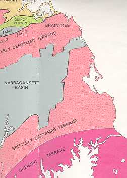
Tectonic Map of SE Massachusetts showing the Narragansett Basin and crystalline rocks (from E. Zen 1983).
Plymouth County Soil Survey
General Geology of Plymouth County (Geology
Links)
By
Jim Turenne
Recommended Books: Roadside Geology of Massachusetts (James William Skehan)
Cape Cod and the Islands: The Geologic Story (Bob Oldale)
The U.S Geologic Survey (USDI) is responsible for mapping the Nation's bedrock and surficial geology. This section provides general geology information about Plymouth County as it relates to and influences the soil resources. For more information about the geology of Plymouth County contact the USGS.
Generalized bedrock and surficial geology maps for Plymouth County will be included with the published Soil Survey of Plymouth County when published. The major geologic events which influence the development (genesis) and behavior of the soils in Plymouth County are; the formation of basement rock during the late Precambrian (Proterozoic) and Paleozoic era, the Pleistocene glaciation, and post glacial Holocene deposition.
Bedrock Geology:
The generalized bedrock geology map (below) shows two general types of bedrock underlie the soil and surficial deposits in Plymouth County. The type of bedrock has a very important role in chemical and physical properties associated with the development of the soils within the region. The type and depth to bedrock also has influence on water movement and availability, construction site limitations, and plant growth. Soils are classified to a depth of 65 inches. Soil depth classes are related to the depth to hard bedrock. Very deep soils do not have bedrock within 65 inches, moderately deep soils have bedrock between 20 and 40 inches (Chatfield Series), and shallow soils have bedrock within 20 inches (Hollis Series). Areas of bedrock controlled uplands are mapped in a complex of the various depth classes depending on the percentage of each soil type.
Tectonic Map of SE Massachusetts showing the Narragansett Basin and
crystalline rocks (from E. Zen 1983).
The bedrock in the northern and southern portion of Plymouth County consists of crystalline igneous and metamorphic late Proterozoic and Paleozoic aged rocks. Bedrock outcrops and shallow to moderately deep soils are common in the northern part of Plymouth County and in a small area near route 140 in the town of Lakeville (rocky woods). The crystalline rocks are buried very deep by glacial deposits in the southeastern part of the County, ranging from 100 to 300 feet below the surface. The central part of the County lies within the Narragansett Rift Basin and consists primarily of Pennsylvanian aged (Carboniferous) meta-sedimentary rocks. The rocks of the Narragansett Basin typically consist of highly folded and fractured, dark colored siltstone, shale, graywacke, argillite, and coarse-grained conglomerate. Bedrock outcrops in the Narragansett Basin are few and scattered throughout the region; thick glacial deposits overlie most of the basin.
The entire County is part of the Avalonian Tectonic Terrane (Milford-Dedham Zone). The Avalon zone is an eastern platform or basement that evolved to some extent independently of the North American continent. The zone existed as an island or microcontinent within the proto-Atlantic (Iapetus) ocean until incorporation into the Appalachians no earlier than early Paleozoic time (O'Hara, 1986) ). A modern analogy of Avalon is the Island of Japan which detached from mainland Eurasia and is moving eastward and possibly collide with North America. The Alleghanian orogeny (mid to late Paleozoic) in southeastern New England is believed to represent the final amalgamation of Avalonian terranes against Laurentia during the collision between Laurentia and Africa (Burks 1998).
Surficial Geology:
The Pleistocene epoch (approximately 1.64 Ma. To 10 Ka. BP) was the time of the great ice ages. During this time the earth's climate was colder than today, snowfall exceeded snowmelt and as a result huge ice sheets (glaciers) began to move southward from the north. As temperatures warmed, the ice retreated back to the north and an interglacial period began until another glacial re-advance occurred. There is evidence that this pattern of glaciation and interglacial periods occurred at least four major times during the Pleistocene. Many geologists believe that we are currently in an interglacial period and that the ice may someday return.
The last glacial period was called the Wisconsinan glaciation, named for the State of Wisconsin where evidence of the glacial event is recorded in the till. During this period, the Laurentide ice sheet covered all of southern New England reaching its terminus about 25,000 years BP. The terminal moraines which formed the outer islands of Nantucket, Martha's Vineyard, Block Island (RI), and Long Island (N.Y.) mark the furthest extent of the Wisconsinan glaciation in southeastern New England. By approximately 14,000 years BP, the glacier began to retreat to a position north of Boston by approximately 13,000 years ago the ice had left New England (Hansen, 1992).
The generalized surficial geology map for Plymouth County (377KB file) shows the type of sediments (surficial material) deposited by the glacier as it advanced through the area and the sediments deposited as the ice was retreating. These glacial deposits make up the parent material the soils formed in, often called the soil substratum. Four dominant types of glacial deposits occur in Plymouth County; till, fluvial, ice-contact, and lacustrine.
The first type of material was deposited directly by the glacier as it was advancing, the material is called till. Till is unsorted, unstratified material that consists of a heterogeneous mixture of clay to boulder size particles. There are several different types of till that are mapped in Plymouth County including basal or lodgment till (dense till), loose, sandy ablation till and debris flow till. Soils developed in dense till have a compact substratum, which has very slow permeability, and often have perched seasonal high watertables. Some examples of glacial till soils mapped in Plymouth County includes the Paxton, Montauk, Woodbridge, and Brockton series. Ablation till is a looser, sandier till than basal till, it was deposited during the downwasting of the static ice either contained within the ice (englacial) or on the surface of the ice (superglacial). Soils formed in ablation till include the Canton, Gloucester, and Plymouth series. Soils developed in glacial till have a high percentage of surface and subsurface rock fragments (gravel to boulder size), the upland soils are capped with an eolian mantle of sand to silty soil textures.
As the glacier began to retreat to the north, the huge amounts of water contained in the ice melted forming large rivers, temporary lakes, and braided streams which deposited material called outwash or fluvial sediments. Outwash or fluvial deposits consists of stratified sand and gravel deposited from glacial melt-water. Landforms associated with outwash deposits are plains, deltas, eskers, kames, and kettles. Outwash deposits are very important aquifer recharge areas, often are prime farmland areas, and commercially important sources of sand and gravel. Some examples of outwash soils mapped in Plymouth County include the Hinckley, Carver, Sudbury and Scarboro series.
The third type of glacial material is called lacustrine or lake floor deposits. Lacustrine deposits are fine-textured material deposited in open glacial lakes which have since drained or filled with sediments. Lacustrine soils mapped in Plymouth County include Scio, Eldridge, and Raynham series. Lacustrine soils tend to have a very slowly permeable substratum, which causes seasonal high watertables.
Post-Glacial Deposits:
Eolian Mantle:
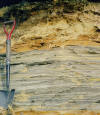
The Wisconsin glaciation ended approximately 10,000 years ago leading the way into start of the Holocene epoch, which we are currently in. With the glacial ice receded back up into Canada, the Holocene epoch marks time zero for the start of soil formation. An important event, which occurred during the early Holocene, was the deposition of a wind-blown (eolian) mantle of sand to silt size particles over the barren glacial sediments (till, outwash, and lacustrine). The cause for the eolian depositional event was strong winds (katabatic winds) generated from the proximity of glacial ice and the barren land. The land warmed up faster than the ice and as the hot air rose, the colder air blowing off the ice replaced it generating the strong winds. Rock fragments in the eolian mantle are often fluted and polished from the wind-driven sand grains that sandblasted the fragments producing what are called ventifacts. The eolian mantle ranges from less than 10 inches up to approximately 40 inches in thickness. Most of the upland soils in New England have this eolian mantle but some do not, particularly wet soils such as the Freetown and Swansea series. Areas where the eolian deposit is thicker than 40 inches are in coastal areas on dunes and coastal banks, the Hooksan series is an example of this thick eolian deposit. USDA soil textures of the eolian mantle range from coarse sand (Carver series) to silt loam (Scio series), the eolian deposit formed the solum (A and B soil horizons) of the soils in the New England area. The thickness and texture of the mantle is one of the factors used to classify and delineate many of the soils in Plymouth County. Without this mantle of friable material, the soils would be pretty difficult to farm and support forests.
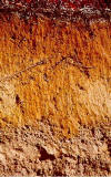
Soil profile showing a thick eolian mantle underlain by outwash deposits.
Organic sediments:
Deposited in open water and lowland positions on the landscape such as bogs, swamps, and fens (collectively refereed to as "peatlands"). Organic sediments accumulate because there is a higher rate of deposition than decomposition, primarily due to the anaerobic (without oxygen) nature of peatlands. The organic soils of Plymouth County consists of freshwater organic sediments (Freetown and Swansea soils) and saltwater organic sediments in tidal marshes (Ipswich and Pawcatuck soils). A lot of the freshwater organic soils are used for the production of cranberries, other areas occupy the large swamps and bogs of the county. The Hockomock Swamp located in the west-central part of Plymouth County (and adjacent Bristol County) is a 6,000 acre peatland consisting of shallow to deep organic soils (Swansea and Freetown) and mineral Saco soils. Ground penetrating radar studies by the NRCS show that some of these peatlands are over 30 feet deep, with reports showing the peat up to 60 feet (Hartshorn, 1960) thick primarily in kettle bogs.
Alluvial Deposits:
Sediments deposited in modern day floodplains of major river and streams are called alluvial deposits. Most of the alluvial soils in Plymouth County are mapped along the Taunton River and the North River. Alluvial soils are prone to periodic flooding and are unsuited for most commercial uses. Examples of alluvial soils are the Hadley, Saco, Limerick, and Winooski series.
Human or Anthro - Transported Material:
The last geologic agent to affect the area is humanity. Bulldozers for moving sand and gravel, dynamite for blasting rock, and the construction of homes, landfills, buildings and highways change the landscape as surely as any "natural" agent does. Two mechanisms of human alteration of the soil and geology are excavation of material (cuts), and deposition of material over existing soil and/or geologic material (fills). Human disturbed soils vary a great deal and since they do not follow the natural development (soil genesis) of un-disturbed soils, they are difficult to map accurately on the landscape. Examples of soil types associated with human alteration are the Udorthent and Udipsamment map units.
Plymouth County contains some classic geologic areas and landforms, which have historic and environmental importance. The following is a description of some of these geologic areas of the County:
The End Moraines and the Wareham - Carver Pitted Outwash Plains: (Click for Map from Hansen, 1992)
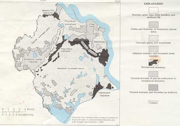
The southeastern part of Plymouth County lies within the Embayed Section of the Coastal Plain physiographic province of New England (Hunt, 1967). The depth to basement rock is very deep within this region, ranging from approximately 100 to 300 feet below sea level. As the glacier was retreating northward, two main lobes from the ice sheet; the Buzzards Bay and the Cape Cod Bay lobes, formed a series of end moraines and pitted outwash plains, as well as ice marginal lakes (Larson 1982). The recessional moraines show the position of the ice margin and records of minor readvances during the deglaciation of this region. The Hog Rock, Snipatuit, and Middleboro moraines mark the retreat positions of the Buzzards Bay lobe, the Ellisville moraine mark the retreat positions of the Cape Cod Bay lobe. The Monks Hill moraine was deposited at the confluence of both lobes. Most of the moraines in Plymouth County are composed of collapsed sand and gravel with minor amounts of loose, sandy till interbedded. The moraines are capped by a thin, discontinuous veneer of sandy till indicating a readvance of the glacier. The moraines are identified by elevation, landform, and the presence of surface boulders. Soils commonly mapped on the moraines are the Plymouth, Carver, Barnstable, Canton, and Montauk series.
South of the end moraine's lie a series of large outwash plains called the Wareham-Carver pitted outwash plain. The outwash is composed mostly of coarse sand and gravel that is hundreds of feet thick. The outwash plains and moraines are "pitted" with kettle holes which were formed by blocks of detached ice that were buried in the sediment for many years until they melted leaving a depression. If the kettle hole was deep enough to intercept the watertable it formed a kettle pond such as Charge Pond in Wareham. Some of the kettle ponds eventually filled with organic sediments forming bogs. Many of the peat filled kettle holes are used for cranberry production. The Carver, Merrimac, Hinckley, and Freetown soils are typically mapped on the outwash plains. The area of the Wareham-Carver pitted outwash plain is part of the 500 billion gallon Plymouth-Carver Aquifer, the second largest aquifer in Massachusetts (Hansen, 1992).
Glacial Lake Taunton and the Jones River Lowland:
The retreat of the ice front formed a series of glacial lakes in low areas between the ice margin and the deglaciated terrain. The largest glacial lake in southeastern Massachusetts developed in the Taunton River valley and is commonly refereed to as Glacial Lake Taunton; it covers the west-central part of Plymouth County and extends into Bristol County. The lake surface was approximately 55-65 feet above present sea level. Deposited within this lake are fine textured sediments consisting of varved silts and clays greater than 100 feet thick in some areas (Hartshorn, 1960). The Jones River was the outlet for the lake during its final stages before filling with sediments. The clay deposited within the lake has been mined for making bricks. Soils associated with Glacial Lake Taunton include the Scio, Raynham, Birdsall and Enosburg series; some of the best farmland soils are mapped within this area. Large peatlands such as the Hockomock Swamp, the largest continuous swamp in southern New England, have formed in the low elevations of Glacial Lake Taunton.
Drumlins are smooth, oval shaped, streamline hills that are aligned with the direction of flow of the glacier. They are composed of dense basal till material which ranges in color, texture, and firmness depending on the type of material contained in the till as it was deposited. The exact formation of drumlins is not known, they are thought to form in areas of bedrock highs. When the advancing glacier hit the bedrock high a deposition of material occurred and continued while the ice advanced through the area. Geologists recognize two distinct tills deposited on drumlins in the area, an upper till believed to be Wisconsin aged, and a lower till of Illinoian age. Since soils are only classified to a depth of 65-72 inches, most of the soils formed in upper till. A layer of loose ablation till often occurs above the dense drumlin till.
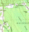
USGS topographic map (Assawompsett Pond Quad) showing dumlins, not
orientation (NW to SE - the direction of ice flow)
Three types of drumlin till are mapped associated with the soils of Plymouth County. In the northwestern part of the county, the glacier traveled through the Boston Basin, an area composed of dark colored metasedimentary Cambrian aged bedrock called the Boston Bay group. The till deposited to the south of this basin has a high percentage of the dark mineralogy and rock fragments, its fine textured, and very firm. The Newport and Pittstown soils are mapped on this type of till. The dark till is also found discontinuously in the Narragansett Basin in the Brockton, Bridgewater and Middleboro area. The second type of drumlin till mapped on well-formed drumlins in the northeast and central parts of the county is an olive colored, loamy, and very dense till. The Paxton and Woodbridge soils are commonly mapped on this type of till. The third type of drumlin till, also mapped on moraines, is a light colored, sandier, and slightly looser till with high percentages of granitic rock fragments. Montauk and Scituate soils are mapped on this type of till, mainly in the southeastern part of the county but also scattered through the county.
Coastal Plain Deposits and The Marshfield Hills:
At the end of Tertiary time (65-1.5 million years ago) the Atlantic Coastal Plain rimmed all of New England, just as it does the eastern seaboard of the United States today, south of the limits of the Pleistocene glaciation. The continental glaciation deformed and removed the soft Coastal Plain sediments that lay in the paths of the ice sheets. In-place (in situ) Coastal Plain deposits are found in only one place in New England: the Marshfield-Duxbury area of Massachusetts (Kaye, 1983). Out of place (allochthonous or morainic) Coastal Plain deposits are also found in the Marshfield area and in the outer islands of Massachusetts and Rhode Island, and Long Island, NY and occur as thrust sheets which were pushed up by glaicial ice at it’s terminus. The Coastal Plain deposits consist of various colored (red, white, gray) silty and clayey material, highly fossiliferous greensand, and shelly sandy deposits. In most places glacial deposits of variable thickness overlie the buried Coastal Plain deposits.
In the northeastern part of Plymouth County (towns of Marshfield, Duxbury, and Scituate) lies a cluster of irregularly shaped hills ranging from 45 to 60 meters in height called the Marshfield Hills moraine. The hills consists of variable deposits sandy ablation till, ice-contact outwash, and dense till capped with sandy to silty eolian material. In some places of these hills and other scattered localities underlying the glacial deposits are dark gray Tertiary aged silts and clays called the Marshfield Hills Formation (Kay, 1983). The silts and clays are in thrusts sheets separated by pre-Wisconsinan glacial sand and gravel. The Marshfield Hills Formation is described as very compact, dark gray to black, highly micaceous and in places slightly glauconitic. The dark coloration is due to both very fine-grained carbonaceous material and iron sulphides (Kay, 1983).
The Marshfield Hills Formation
Attempts were made to map out the soil areas where these fine-textured deposits occur, due to some of the major soil limitations associated with the material. Soils are classified to a depth of 2 meters, below this depth are surficial geologic material mapped by the U.S. Geologic Survey. A ground penetrating radar was used to determine the depth to the silts and clays within the Marshfield Hills area and other areas where soil scientists encountered the deposit. Where the silts and clays occurred below the 2 meter depth, the soils were mapped based on their proper classification.
References:
O'Hara, K.D., and L.P. Gromet, Two distinct Later Precambrian (Avalonia) terranes in southeastern New England and their Late Paleozoic juxtaposition, American Journal of Science, 285, 673-709, 1985.
Burks, R.J., Mosher, S., and Murray D.P., 1998, Characterizing the Alleghanian Orogeny in Southeastern New England: A west to East Traverse Across the Southern Narragansett Basin: in Murray, D.P., ed., Guidebook to Field Trips in Rhode Island and Adjacent Regions of Connecticut and Massachusetts, New England Intercollegiate Geological Conference, 90th Annual Meeting, p. B4-1:21.
Hunt, Charles B., 1967. Physiography of the United States. W.H. Freeman Company. San Francisco and London.
Larson, G.H., 1982, Nonsynchronous retreat of ice lobes from southeastern Massachusetts, in Larson, G.H., and Stone, B.D., eds., Late Wisconsinan Glaciation of New England: Dubeque, Iowa, Kendall/Hunt Publishing Co., p. 101-114.
Hansen B. P., and Lapham W. W., 1992, Geohydrology and Simulated Ground-Water Flow, Plymouth-Carver Aquifer, Southeastern Massachusetts: U. S. Geological Survey Water Resources Investigations Report 90-4204.
Hartshorn, J.H., 1960, Geology of the Bridgewater quadrangle, Massachusetts: U.S. Geologic Survey Quadrangle Map GQ-127.
Kay, Clifford A., 1983, The Autochthonous and Allochthonous Coastal Plain Deposits of Martha’s Vineyard and the Marshfield-Scituate Area, Southeastern Massachusetts, Atlantic Coastal Plain Geological Association Field Trip Guidebook Martha’s Vineyard, Massachusetts, October 1-2, 1993.
Zen, E-an, ed., Goldsmith, R., Ratcliffe, N. M. Robinson, P. , Stanley, R.S., compilers, 1983, Bedrock Geologic Map of Massachusetts: U.S. Geol Survey, 3 sheets, scale 1:250,000.
Geology Links:
A
Hypertext in Glacial Geology - Excellent glacial geology
information
A Tapestry of
Time and Terrain
Friends
of the Pleistocene
Geologic
Ages of Earth History - Download the excel spreadsheet
Geology
Wing Entrance (Geologic Time & Plate Tectonics)
Glacial
Geology at the University of Cincinnati
Link to
USGS Glossary of Geologic Terms
This
Dynamic Earth (USGS)
URI Geology Department