A soil survey update is
underway in
Plymouth County Massachusetts. The updated soil survey report is
employing state of the art technology such as
ground
penetrating radar,
high resolution CIR photography, and global positioning systems (GPS)
to produce highly detailed and accurate soil maps. The updated
soil mapping is at a scale of 1:12,000, which allow minimum
delineations down to 1 - 2, acres.
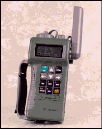
The Global Positioning
System used by the Plymouth County Soil Survey is the Rockwell
International Precision Lightweight GPS Receiver (PLGR). The PLGR
unit measures approximately 10x4x2 inches and weighs 3 pounds
with batteries. The small size and lightweight make the unit easy
to carry and use. The durable plastic case is sealed for all-weather
use. The unit has a built in antenna and has external connectors
for power, antennas, and other accessories. The PLGR unit
provides accuracy to within 4 meters. The PLGR unit has special
encryption codes, which allows for increased accuracy with out
the need for post-processing.
Using
GPS for Field Soil Mapping
The GPS unit was field
tested by the Plymouth County Soil Survey in 1994 to determine
the potential use of the PLGR's for the Survey. Initial field
tests involved determining the accuracy of the unit by locating
known areas and comparing the coordinates to determine the
accuracy. Coordinates from the PLGR were downloaded onto a PC and
Digital Ortho-photography was overlain to see if the PLGR's
location matched the known location of the imagery. The GPS unit
accurately plotted the correct location for the scale of the
field mapping. The next step was to determine its uses for field
mapping.
The GPS unit is carried in
a fanny pack along with other equipment used by soil scientists.
When a location is required the GPS unit displays the coordinate
and stores the location for geo-referencing. The easiest
coordinate system to use in the field is the UTM coordinate
system. This system is based on a 1,000-meter grid, which is
shown on most USGS topographic maps. A Mylar overlay of the
topographic map is enlarged to match the scale of the aerial
photo so the location of site can be pinpointed by the mapper.
Results of the field-testing showed that the GPS provides a wide array of uses for soil survey. The following
is a brief list of some uses for the GPS for soil survey operations:
Locating your position: Most soil maps are
made by soil scientist who traverse the landscape and delineate
soil boundaries on an aerial photograph. Although locating your
position is quite easy in open fields, it can become difficult in
wooded (particularly in areas with low relief) areas and in areas
where land use has changed since the time the photo was taken.
The use of the GPS in conjunction with recent high-resolution CIR
photography makes locating yourself very easy. This end result is
an accurate and detailed soil map.
Recording the location of
profile description sites and field notes: While a soil
survey is in progress, soil scientists collect a wealth of
information about the land within the survey area. Numerous soil
profiles are described and sampled for chemical and physical
properties and many field notes and transects are performed.
Unfortunately most of this information is never made available to
users of soil information. In Plymouth County all field
observations and research sites are geo-referenced with the PLGR's.
A digital (GIS) map is made from the point locations, which
allows user's to click on the point and the attribute data is
linked (via Internet) to the actual data (click
here for an example).
Locating boundaries of recently
altered areas: Although the
Plymouth County Soil Survey Update is using CIR photography flown
in 1993, there are many areas of altered soils, which are
difficult to delineate if the alteration was made after the photo
was taken. Examples of alteration include construction projects,
some of which are very large, gravel pits, subdivisions, new
roads, and cranberry bog construction. Altered soil areas are
mapped out as miscellaneous soil map units based on the type of
alteration. In altered areas the GPS is used to mark the boundary
of the disturbed area so a line can be drawn on the map.
Locating AD HOC spot symbols: Spot symbols are
placed on soil maps for small areas of dissimilar soils, which
cannot be delineated at the scale of mapping, or for locating
important features such as bedrock outcrops and escarpments. In
Plymouth County areas less than 1 to 2 acres cannot be delineated
due to the scale so adhoc spot symbols are placed in these areas.
The GPS is used to pinpoint the location of these spot symbols;
it is particularly useful for locating vernal pools, which can be
very small.
Safety concerns: A soil scientist
typically spends most of their time in the field walking the
landscape. It's not uncommon for a soil scientist to spend a
whole day in dense woods many miles from the vehicle. There are
many safety concerns for a person in such a location such as
injury, heat stroke, dehydration, bee stings, hunters, and
becoming disoriented and lost. When mapping in such areas the GPS
can be a lifesaver. Mappers who are in remote areas can use the
GPS unit and a portable cell phone in case of emergency,
particularly when mapping during the hunting season.