Soil Survey Update - Plymouth County, Massachusetts

NEWS FLASH: Plymouth County Soil Survey is NOW Available on Web Soil Survey and Soil Data Mart or MASSGIS -  IT'S DONE!!!
Presentation from Plymouth Last Acre Ceremony (PDF) | (PPT)

Final Soil Map Unit Legend with linksFinal Soil Map Unit Legend with links
Download Point Observations Locations for Plymouth County - requires Google Earth

The USDA - Natural Resources Conservation Service has COMPLETED the update mapping of the soil survey of Plymouth County, Massachusetts. The mapping was made using high-resolution color infrared aerial photography. The survey also incorporates remote sensing technology including Ground-Penetrating-Radar, Global Positioning Systems, and Geographic Information Systems to produce detailed and accurate soil maps.


1969 Soil Survey Maps

1969 Soil Map Unit Legend

Updated Soil Map Unit Legend (archive version)

General Nature of Plymouth County

General Soil Maps (incomplete)
Soil Catena Chart

Classification of Soils

Formation of Soils

Non-Technical Soil Descriptions

Laboratory Soil Data

Geology of Plymouth County 

Soil Pedon Locations

Climate Table for Plymouth

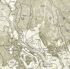
Comparison of the 1969 Plymouth County
Soil Survey (above) with the Updated soil
Mapping (right): Differences include;
Map
Scale - old = 1:20,000 vs. updated = 1:12,000,
Detail (map unit delineation size) - old = 8
acres vs. updated 1-2 acres, Imagery - old =
B&W leaf on poor quality vs. Updated = high
resolution color infrared, leaf off.
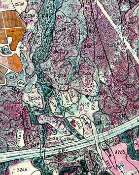
Note the increased detail in the updated mapping
above. There are also major differences in the soil
types mapped between the two maps


For more information contact the Plymouth County Soil Survey:

508-295-5151 x 117
jimturenne@gmail.com