 Click for Photo
PLYMOUTH COUNTY, MASSACHUSETTS SOIL SURVEY UPDATE
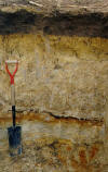
Scio Soils: Very deep, moderately well drained soil formed in glacial lacustrine silts and very fine sand. Scio soils are on glacial lake plains, deltas, and low terraces.
Click for Photo
Link
to Official Series Description
Click here for Scio Laboratory Data
S91-MA-023-009, Click Here
for Pedon Description
Scio Pedon Description 2322301 |
Scio Pedon Description 2322302 |
Scio Pedon Description 2322304 |
Scio Pedon Description 2322305
Map
Unit (s): 223A, 223B
Map
Phases:
223A Scio very fine sandy loam, 0 to 3 percent
slopes.
223B Scio very fine sandy loam, 3 to 8 percent
slopes.
Taxonomic
Classification: Coarse - silty, mixed, mesic, Aquic
Dystrochrepts.
Drainage
Class: Moderately well drained.
Parent
Material: Lacustrine silts, very fine sand and silty clay
loam sediments.
Permeability:
Slow to moderately slow.
Available
Water Holding Capacity: Moderate to high.
Soil
Reaction: Very strongly to moderately acid above 40 inches,
and strongly acid to mildly alkaline below 40 inches.
Depth
to Bedrock: Greater than 65 inches.
Seasonal
High Watertable: Depth: 1.5 to 3.5 feet below the
surface.
Type: Perched.
Months: December to April.
Hydrologic
Group: B.
Hydric
Soil: No (may have hydric inclusions).
Flooding/Ponding
Potential: Frequency and Type: None.
Potential
Inclusions: Deerfield and Eldridge soils are similar
inclusions. Poorly drained Enosburg, Raynham, and Wareham soils
are on lower elevations. Well drained Hinesburg, Windsor, and
Wampanucket soils are on higher elevations.
Soil Suitability:
Agriculture: Well suited for most agricultural uses. Scio soils are prime farmland soils.
Woodland: Well suited for woodland.
Development: Major limitations related to seasonal high watertables and slow permeability in the silty substratum.
Back to
Homepage
Back to
Legend