 Tihonet
Profile
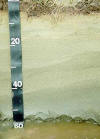
Tihonet
ProfilePLYMOUTH COUNTY, MASSACHUSETTS SOIL SURVEY UPDATE
Tihonet Soils: The Tihonet series consists of very deep, poorly drained soils that formed in thick sandy glacial fluvial deposits. They are on excavated landscapes where the original solum and substratum has been excavated to the depth of the apparent water table.
Link
to Official Series Description
Pedon Description 00565701 |
Pedon Description 2365701 |
Pedon Description 2302302 |
Tihonet Pedon S07MA023001 |
Pedon description and Laboratory
Analysis S07MA023001
Map
Unit (s): 23, 657
Map
Phase:
23A: Tihonet coarse sand, 0 to 3 percent slopes.
657: Tihonet sand, 0 to 3 percent slopes (formerly called Aquents).
Taxonomic
Classification: Mixed, mesic Typic Psammaquents.
Drainage
Class: Poorly drained.
Parent
Material: Human altered material underlain by glacial fluvial deposits.
Permeability: Rapid to very rapid
throughout.
Available
Water Holding Capacity: Low.
Soil
Reaction: Extremely acid to Strongly acid throughout.
Depth
to Bedrock: Greater than 60 inches.
Seasonal
High Watertable: Depth: 3.0 feet above to 1.5 feet below the
surface. Type: Apparent.
Months: November to June.
Hydrologic
Group: C.
Hydric
Soil: Yes.
Flooding/Ponding
Potential: Frequency and Type: Frequently Flooded and/or Ponded.
Duration and Months: Brief to long, November to May. Regulated by human
activities.
Soil Suitability:
Agriculture: Map unit 23 is used for Cranberry production click here for more information. Map unit 657 is poorly suited for most agricultural uses mainly due to wetness.
Woodland: Poorly suited due to wetness.
Development: Wetness, due to seasonal high water table limits the use of this soil as a site for dwellings and for septic tank absorption fields. The nature of the wet sandy soils causes sloughing and pit collapse during excavation.
Back to
Homepage
Back to
Legend