Soil Survey Update - Plymouth County, Massachusetts

INFORMATION ON THIS SITE IS SUBJECT TO CHANGE

Download Point Observations Locations for Plymouth County - requires Google Earth

The USDA - Natural Resources Conservation Service is in the process of updating the soil survey of Plymouth County, Massachusetts. The mapping is made using high-resolution color infrared aerial photography. The survey also incorporates remote sensing technology including Ground-Penetrating-Radar, Global Positioning Systems, and Geographic Information Systems to produce detailed and accurate soil maps.

Updated mapping is still in progress, a completion date of 2006 is set for the County (digitized maps may be available prior to the completion date). The old 1969 soil survey maps have been scanned and posted on the web as gif images (see link below), a status map of the updated mapping is at the bottom of this page. If you would like to check to see if we have advance copies of our field mapping, fax a USGS topographic map with the area highlighted and we will send you a copy of the mapping. Fax the map to: Soils, 508-291-2368. If you do not have a Topo map go to www.topozone.com or Maptech Map Server and email me the map.

1969 Soil Survey Maps

1969 Soil Map Unit Legend

Updated Soil Map Unit Legend

General Nature of Plymouth County

General Soil Maps (incomplete)

Soil Catena Chart

Classification of Soils

Formation of Soils

Non-Technical Soil Descriptions

Laboratory Soil Data

Geology of Plymouth County 

Soil Pedon Locations

Climate Table for Plymouth

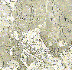
Comparison of the 1969 Plymouth County
Soil Survey (above) with the Updated soil
Mapping (right): Differences include;
Map
Scale - old = 1:20,000 vs. updated = 1:12,000,
Detail (map unit delineation size) - old = 8
acres vs. updated 1-2 acres, Imagery - old =
B&W leaf on poor quality vs. Updated = high
resolution color infrared, leaf off.
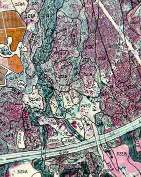
Note the increased detail in the updated mapping
above. There are also major differences in the soil
types mapped between the two maps

Status Map of the Updated Soil Mapping for Plymouth County as of January 2002 (green areas have updated mapping, yellow and red areas are currently being updated and not available)

For more information contact the Plymouth County Soil Survey:

508-295-5151 x 117
jimjet@cox.net


Page Maintained by Jim Turenne

Base URL: http://nesoil.com/index.html